Grade I listed buildings in Exeter

Map all coordinates using OpenStreetMap
Download coordinates as:
- KML
- GPX (all coordinates)
- GPX (primary coordinates)
- GPX (secondary coordinates)
There are over 9,000 Grade I listed buildings in England. This page is a list of these buildings in the district of Exeter in Devon.
Exeter
| Name | Location | Type | Completed [note 1] | Date designated | Grid ref.[note 2] Geo-coordinates | Entry number [note 3] | Image |
|---|---|---|---|---|---|---|---|
| Bowhill | Exeter | House | c. 1500 | 29 January 1953 | SX9065291592 50°42′49″N 3°33′01″W / 50.713641°N 3.550181°W / 50.713641; -3.550181 (Bowhill) | 1103985 |  More images |
| Cathedral Church of St Peter | Exeter | Cathedral | Mid 14th century | 29 January 1953 | SX9211592550 50°43′21″N 3°31′47″W / 50.722527°N 3.529747°W / 50.722527; -3.529747 (Cathedral Church of St Peter) | 1333352 |  More images |
| Church of St David | Exeter | Church | 1897–99 | 29 January 1953 | SX9153293103 50°43′39″N 3°32′17″W / 50.727389°N 3.538166°W / 50.727389; -3.538166 (Church of St David) | 1267226 |  More images |
| Church of St Mary Steps | Exeter | Church | 15th century | 29 January 1953 | SX9176092267 50°43′12″N 3°32′05″W / 50.719917°N 3.534691°W / 50.719917; -3.534691 (Church of St Mary Steps) | 1224263 | 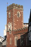 More images |
| Church of St Michael and All Angels | Exeter | Chapel of ease | 1865–68 | 18 June 1974 | SX9156892709 50°43′26″N 3°32′15″W / 50.723854°N 3.53754°W / 50.723854; -3.53754 (Church of St Michael and All Angels) | 1170013 |  More images |
| Church of St Thomas the Apostle | Exeter | Church | Consecrated 1412 | 29 January 1953 | SX9122291818 50°42′57″N 3°32′32″W / 50.71578°N 3.542177°W / 50.71578; -3.542177 (Church of St Thomas the Apostle) | 1169954 |  More images |
| Custom House, Wharfinger's House and Attached Warehouse | Exeter | Custom house | 1680–81 | 29 January 1953 | SX9196392147 50°43′08″N 3°31′54″W / 50.718876°N 3.531781°W / 50.718876; -3.531781 (Custom House, Wharfinger's House and Attached Warehouse) | 1223038 |  More images |
| Gatehouse to Bishop's Palace | Exeter | Gatehouse | Probably 14th century | 29 January 1953 | SX9211892429 50°43′17″N 3°31′47″W / 50.72144°N 3.529669°W / 50.72144; -3.529669 (Gatehouse to Bishop's Palace) | 1222909 | 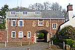 More images |
| George's Chapel | Exeter | Unitarian chapel | 1760 | 29 January 1953 | SX9210492342 50°43′14″N 3°31′47″W / 50.720655°N 3.529842°W / 50.720655; -3.529842 (George's Chapel) | 1267126 | 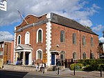 More images |
| Mol's Coffee House | Exeter | Timber-framed house | 1596 | 29 January 1953 | SX9210392649 50°43′24″N 3°31′48″W / 50.723414°N 3.529946°W / 50.723414; -3.529946 (Mol's Coffee House) | 1104060 |  More images |
| Former Presentation of St Mary Convent School, Palace Gate | Exeter | Archdeaconry | Mid to late 15th century | 18 June 1974 | SX9212392374 50°43′15″N 3°31′46″W / 50.720946°N 3.529582°W / 50.720946; -3.529582 (Former Presentation of St Mary Convent School, Palace Gate) | 1222911 |  Upload Photo |
| Quay House Visitor Centre | Exeter | Warehouse | 1679–80 | 18 June 1974 | SX9201992129 50°43′07″N 3°31′52″W / 50.718724°N 3.530983°W / 50.718724; -3.530983 (Quay House Visitor Centre) | 1223072 |  More images |
| Rougemont Castle | Exeter | Castle | Norman | 29 January 1953 | SX9207192937 50°43′34″N 3°31′50″W / 50.725997°N 3.530484°W / 50.725997; -3.530484 (Rougemont Castle) | 1104054 |  More images |
| St Martin's Church | Exeter | Church | Late 14th century | 29 January 1953 | SX9210392655 50°43′24″N 3°31′48″W / 50.723468°N 3.529948°W / 50.723468; -3.529948 (St Martin's Church) | 1169625 |  More images |
| St Mary Arches Church | Exeter | Church | 12th century | 29 January 1953 | SX9182892533 50°43′20″N 3°32′02″W / 50.72232°N 3.533806°W / 50.72232; -3.533806 (St Mary Arches Church) | 1239677 | 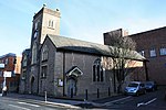 More images |
| St Nicholas Priory | Exeter | Priory | Medieval | 29 January 1953 | SX9173892485 50°43′19″N 3°32′06″W / 50.721872°N 3.535067°W / 50.721872; -3.535067 (St Nicholas Priory) | 1239752 | 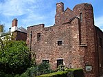 More images |
| The Bishop's Palace | Exeter | Bishop's palace | 13th century | 15 January 1964 | SX9214792506 50°43′20″N 3°31′45″W / 50.722137°N 3.529281°W / 50.722137; -3.529281 (The Bishop's Palace) | 1222943 |  More images |
| The Guildhall | Exeter | Guildhall | 1468–70 | 29 January 1953 | SX9197092651 50°43′24″N 3°31′55″W / 50.723408°N 3.53183°W / 50.723408; -3.53183 (The Guildhall) | 1103905 |  More images |
| Former Law Library, rear of 9 Cathedral Close | Exeter | Hall | Probably 15th century | 29 January 1953 | SX9216692608 50°43′23″N 3°31′45″W / 50.723058°N 3.529042°W / 50.723058; -3.529042 (Former Law Library, rear of 9 Cathedral Close) | 1104063 | Upload Photo |
| 5 Cathedral Close | Exeter | House | Late 17th century | 29 January 1953 | SX9212692634 50°43′24″N 3°31′47″W / 50.723284°N 3.529616°W / 50.723284; -3.529616 (5 Cathedral Close) | 1169638 |  More images |
| 8, 9 and 9a Cathedral Close | Exeter | Jettied house | Probably c. 1450 | 29 January 1953 | SX9216092602 50°43′23″N 3°31′45″W / 50.723003°N 3.529125°W / 50.723003; -3.529125 (8, 9 and 9a Cathedral Close) | 1306441 |  More images |
| 10 Cathedral Close | Exeter | Archdeaconry | Medieval | 29 January 1953 | SX9218392583 50°43′22″N 3°31′44″W / 50.722836°N 3.528794°W / 50.722836; -3.528794 (10 Cathedral Close) | 1333331 | 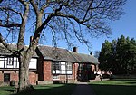 More images |
See also
Notes
- ^ The date given is the date used by Historic England as significant for the initial building or that of an important part in the structure's description.
- ^ Sometimes known as OSGB36, the grid reference is based on the British national grid reference system used by the Ordnance Survey.
- ^ The "List Entry Number" is a unique number assigned to each listed building and scheduled monument by Historic England.
External links
![]() Media related to Grade I listed buildings in Exeter at Wikimedia Commons
Media related to Grade I listed buildings in Exeter at Wikimedia Commons
- v
- t
- e
- Bedfordshire
- Berkshire
- Bristol
- Buckinghamshire
- Cambridgeshire
- Cheshire
- Cornwall
- Cumbria
- Derbyshire
- Devon
- Dorset
- Durham
- East Sussex
- East Riding of Yorkshire
- Essex
- Gloucestershire
- Greater London
- Greater Manchester
- Hampshire
- Herefordshire
- Hertfordshire
- Isle of Wight
- Kent
- Lancashire
- Leicestershire
- Lincolnshire
- Merseyside
- Norfolk
- North Yorkshire
- Northamptonshire
- Northumberland
- Nottinghamshire
- Oxfordshire
- Rutland
- Shropshire
- Somerset
- South Yorkshire
- Staffordshire
- Suffolk
- Surrey
- Tyne and Wear
- Warwickshire
- West Midlands
- West Sussex
- West Yorkshire
- Wiltshire
- Worcestershire
- Babergh
- Bath and North East Somerset
- Bradford
- Brighton and Hove
- Broadland
- Cheltenham
- Cheshire East
- Cheshire West and Chester
- Cotswold
- Craven
- Dartford
- Dover
- Forest Heath
- Forest of Dean
- Ipswich
- Maidstone
- Mendip
- Mid Suffolk
- North Somerset
- Sedgemoor
- South Gloucestershire
- South Somerset
- St Edmundsbury
- Stroud
- Suffolk Coastal
- Taunton Deane
- Tewkesbury
- Waveney
- West Somerset
- Cambridge
- Coventry
- Exeter
- Gloucester
- Liverpool
- York
- Churches
- War memorials
- 20th century


