Grade I listed buildings in the West Midlands

Map all coordinates using OpenStreetMap
Download coordinates as:
- KML
- GPX (all coordinates)
- GPX (primary coordinates)
- GPX (secondary coordinates)
There are over 9000 Grade I listed buildings in England. This page is a list of these buildings in the county of West Midlands, by borough.
Birmingham
| Name | Location | Type | Completed [note 1] | Date designated | Grid ref.[note 2] Geo-coordinates | Entry number [note 3] | Image |
|---|---|---|---|---|---|---|---|
| Aston Hall | Aston | House | 1618-1635 (1635) | 25 April 1952 | 52°30′21″N 1°52′59″W / 52.505941°N 1.882918°W / 52.505941; -1.882918 (Aston Hall) | 1219847 |  More images |
| Curzon Street Station | Digbeth | Railway station | 1838 (1838) | 25 April 1952 | SP0781287076 52°28′54″N 1°53′11″W / 52.481553°N 1.8864°W / 52.481553; -1.8864 (Curzon Street Station) | 1343086 |  More images |
| Cathedral Church of St Philip | City Centre | Cathedral | 1725 | 25 April 1952 | SP0696387032 52°28′52″N 1°53′56″W / 52.481169°N 1.898902°W / 52.481169; -1.898902 (Cathedral Church of St Philip) | 1076173 | 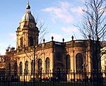 More images |
| Church of St Agatha | Sparkbrook (listed as Highgate) | Church | 1899-1901 (1901) | 21 January 1970 | SP0866784778 52°27′39″N 1°52′26″W / 52.460882°N 1.873869°W / 52.460882; -1.873869 (Church of St Agatha) | 1210221 | 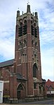 More images |
| Church of St Edburgha | Yardley | Church | 13th century | 25 April 1952 | SP1350386295 52°28′28″N 1°48′09″W / 52.474422°N 1.802634°W / 52.474422; -1.802634 (Church of St Edburgha) | 1343385 | 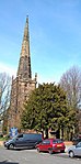 More images |
| Church of St Laurence | Northfield | Church | 12th century | 25 April 1952 | SP0254579343 52°24′43″N 1°57′50″W / 52.412082°N 1.964011°W / 52.412082; -1.964011 (Church of St Laurence) | 1075684 |  More images |
| Church of St Nicolas | Kings Norton | Church | 13th and 14th century | 25 April 1952 | SP0493478962 52°24′31″N 1°55′44″W / 52.408641°N 1.928894°W / 52.408641; -1.928894 (Church of St Nicolas) | 1075549 |  More images |
| St Paul's Church | Hockley | Church | 1776-1779 (1779) | 25 April 1952 | SP0649487483 52°29′07″N 1°54′21″W / 52.485229°N 1.905799°W / 52.485229; -1.905799 (St Paul's Church) | 1220815 |  More images |
| Church of the Holy Trinity | Sutton Coldfield | Church | 1748 (1748) | 18 October 1949 | SP1219096280 52°33′51″N 1°49′18″W / 52.564216°N 1.821601°W / 52.564216; -1.821601 (Church of the Holy Trinity) | 1319961 | 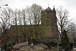 More images |
| Garden wall and gate piers to The Homestead, No. 25 Woodbourne Road | Edgbaston | Gate Pier | 1897 | 8 July 1982 | SP0307385934 52°28′17″N 1°57′22″W / 52.471333°N 1.95619°W / 52.471333; -1.95619 (Garden wall and gate piers to The Homestead, No. 25 Woodbourne Road) | 1211502 | 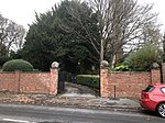 |
| Hall of Memory | City Centre | War Memorial | 1925 | 27 October 2014 | 52°28′17″N 1°57′22″W / 52.471333°N 1.95619°W / 52.471333; -1.95619 (Hall of Memory) | 1244943 | 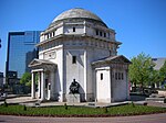 More images |
| Lodges linked by flanking walls to east front of Aston Hall | Aston | Wall | circa 1635 | 25 April 1952 | SP0799489815 52°30′22″N 1°53′01″W / 52.506174°N 1.883655°W / 52.506174; -1.883655 (Lodges linked by flanking walls to east front of Aston Hall) | 1075746 |  |
| Mortuary Chapel at Handsworth Cemetery | Handsworth | Mortuary Chapel | 1909-1910 (1910) | 8 July 1982 | SP0295490731 52°30′52″N 1°57′28″W / 52.514458°N 1.957901°W / 52.514458; -1.957901 (Mortuary Chapel at Handsworth Cemetery) | 1076218 |  More images |
| New Hall Manor | Sutton Coldfield | House | Late 16th century | 18 October 1949 | SP1325694894 52°33′06″N 1°48′21″W / 52.551732°N 1.805931°W / 52.551732; -1.805931 (New Hall Manor) | 1116276 |  More images |
| Parish Church of St Andrew | Handsworth | Parish Church | 1907-1909 (1909) | 8 July 1982 | SP0442690695 52°30′51″N 1°56′10″W / 52.514125°N 1.936211°W / 52.514125; -1.936211 (Parish Church of St Andrew) | 1076219 |  More images |
| Birmingham School of Art | City Centre | Art School | 1881-1885 (1885) | 21 January 1970 | SP0666087027 52°28′52″N 1°54′12″W / 52.481128°N 1.903364°W / 52.481128; -1.903364 (Birmingham School of Art) | 1076258 |  More images |
| Barber Institute of Fine Arts | City Centre | Art gallery and concert hall | 1939-1935 (1935) | 19 March 1981 | SP0491183650 52°27′02″N 1°55′40″W / 52.450419°N 1.927728°W / 52.450419; -1.927728 (Barber Institute of Fine Arts) | 1216784 |  More images |
| Stable range to north of northern lodge, Aston Hall | Aston | Stable | Mid 18th century | 25 April 1952 | SP0800489899 52°30′25″N 1°53′01″W / 52.506929°N 1.883506°W / 52.506929; -1.883506 (Stable range to north of northern lodge, Aston Hall) | 1075747 | 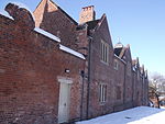 More images |
| The Homestead, 25 Woodbourne Road | Edgbaston | House | 1897 (1897) | 8 July 1982 | SP0310185970 52°28′18″N 1°57′21″W / 52.471656°N 1.955778°W / 52.471656; -1.955778 (The Homestead, 25 Woodbourne Road) | 1076065 |  Upload Photo |
| Birmingham Town Hall | City Centre | Town Hall | 1830 | 25 April 1952 | SP0664086849 52°28′46″N 1°54′13″W / 52.479528°N 1.903662°W / 52.479528; -1.903662 (Birmingham Town Hall) | 1343161 | 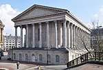 More images |
| Victoria Law Courts | City Centre | Law Court | 1887-1891 (1891) | 21 January 1970 | SP0731387308 52°29′01″N 1°53′37″W / 52.483646°N 1.893743°W / 52.483646; -1.893743 (Victoria Law Courts) | 1075605 |  More images |
| No. 21 Yateley Road | Edgbaston | House | 1899 (1899) | 8 July 1982 | SP0409685117 52°27′50″N 1°56′28″W / 52.463982°N 1.94114°W / 52.463982; -1.94114 (No. 21 Yateley Road) | 1076073 |  More images |
| No. 122 and 124 Colmore Row | City Centre | Commercial Office | 1900 (1900) | 21 January 1970 | SP0676586932 52°28′49″N 1°54′07″W / 52.480272°N 1.901819°W / 52.480272; -1.901819 (No. 122 and 124 Colmore Row) | 1343375 |  More images |
| No. 103 Edmund Street and 17 and 19 Newhall Street | City Centre | House | 1896 (1896) | 21 January 1970 | SP0679087073 52°28′54″N 1°54′05″W / 52.48154°N 1.901449°W / 52.48154; -1.901449 (No. 103 Edmund Street and 17 and 19 Newhall Street) | 1076238 |  More images |
Wolverhampton
| Name | Location | Type | Completed [note 1] | Date designated | Grid ref.[note 2] Geo-coordinates | Entry number [note 3] | Image |
|---|---|---|---|---|---|---|---|
| Church of St Peter | City of Wolverhampton | Church | Late 13th century | 16 July 1949 | SO9142698793 52°35′13″N 2°07′41″W / 52.586872°N 2.127984°W / 52.586872; -2.127984 (Church of St Peter) | 1282467 |  More images |
| Wightwick Manor | City of Wolverhampton | House | 1893 | 29 July 1950 | SO8694698441 52°35′01″N 2°11′39″W / 52.583618°N 2.194094°W / 52.583618; -2.194094 (Wightwick Manor) | 1201902 |  More images |
Coventry
Dudley
| Name | Location | Type | Completed [note 1] | Date designated | Grid ref.[note 2] Geo-coordinates | Entry number [note 3] | Image |
|---|---|---|---|---|---|---|---|
| Church of St John the Baptist | Halesowen | Parish Church | Norman to Perpendicular | 10 January 1950 | SO9663683583 52°27′01″N 2°03′03″W / 52.450194°N 2.050926°W / 52.450194; -2.050926 (Church of St John the Baptist) | 1063767 |  More images |
| Dudley Castle | Dudley | Kitchen | 14th century | 14 September 1949 | SO9468390678 52°30′50″N 2°04′47″W / 52.513962°N 2.079778°W / 52.513962; -2.079778 (Dudley Castle) | 1343187 |  More images |
| St Thomas' Church, Stourbridge | Stourbridge | Church | 1726 (1726) | 8 November 1949 | SO9003084214 52°27′21″N 2°08′53″W / 52.455785°N 2.148146°W / 52.455785; -2.148146 (St Thomas' Church, Stourbridge) | 1343197 |  More images |
| Dudley Priory | Dudley | Cluniac Monastery | 1160 | 14 September 1949 | SO9433090847 52°30′56″N 2°05′06″W / 52.515478°N 2.084983°W / 52.515478; -2.084983 (Dudley Priory) | 1343217 | 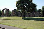 More images |
| Halesowen Abbey | Halesowen | Abbey | 13th century | 10 January 1950 | SO9758482846 52°26′37″N 2°02′13″W / 52.443574°N 2.036971°W / 52.443574; -2.036971 (Halesowen Abbey) | 1063731 | 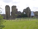 More images |
| The Leasowes | Dudley | House | Early 18th century | 10 January 1950 | SO9795883997 52°27′14″N 2°01′53″W / 52.453923°N 2.031476°W / 52.453923; -2.031476 (The Leasowes) | 1063761 |  More images |
Sandwell
| Name | Location | Type | Completed [note 1] | Date designated | Grid ref.[note 2] Geo-coordinates | Entry number [note 3] | Image |
|---|---|---|---|---|---|---|---|
| Galton Bridge including attached railway bridge span | Smethwick | Footbridge | 1829 (1829) | 2 August 1972 | SP0150289342 52°30′07″N 1°58′45″W / 52.501977°N 1.979303°W / 52.501977; -1.979303 (Galton Bridge including attached railway bridge span) | 1214833 |  More images |
| West Bromwich Manor House | West Bromwich | Courtyard House | circa 1300 | 23 September 1955 | SP0055194316 52°32′48″N 1°59′36″W / 52.546694°N 1.993306°W / 52.546694; -1.993306 (West Bromwich Manor House) | 1077111 |  More images |
Solihull
| Name | Location | Type | Completed [note 1] | Date designated | Grid ref.[note 2] Geo-coordinates | Entry number [note 3] | Image |
|---|---|---|---|---|---|---|---|
| Church of St Mary | Temple Balsall | Church | 1677 (1677) | 8 September 1961 | SP2069975989 52°22′54″N 1°41′50″W / 52.381548°N 1.697329°W / 52.381548; -1.697329 (Church of St Mary) | 1075995 |  More images |
| Church of Saint John the Baptist | Berkswell | Church | Late 12th century | 8 September 1961 | SP2438579162 52°24′36″N 1°38′35″W / 52.409922°N 1.642947°W / 52.409922; -1.642947 (Church of Saint John the Baptist) | 1075974 |  More images |
| Church of Saint Peter | Bickenhill | Parish Church | 12th century | 8 September 1961 | SP1882782409 52°26′22″N 1°43′28″W / 52.439331°N 1.724471°W / 52.439331; -1.724471 (Church of Saint Peter) | 1343224 |  More images |
| Bakehouse at Castle Bromwich Hall | Castle Bromwich | Bakehouse | Late 16th century | 11 November 1952 | SP1430389802 52°30′21″N 1°47′27″W / 52.505929°N 1.790707°W / 52.505929; -1.790707 (Bakehouse at Castle Bromwich Hall) | 1343226 | Upload Photo |
| Castle Bromwich Hall | Castle Bromwich | House | Late 16th or early 17th century | 11 November 1952 | SP1428489779 52°30′21″N 1°47′28″W / 52.505723°N 1.790988°W / 52.505723; -1.790988 (Castle Bromwich Hall) | 1366587 |  More images |
| Church of Saint Mary and Saint Margaret | Castle Bromwich | Church | 15th century | 8 September 1961 | SP1424789859 52°30′23″N 1°47′30″W / 52.506443°N 1.791529°W / 52.506443; -1.791529 (Church of Saint Mary and Saint Margaret) | 1075951 |  More images |
| Church of Saint Mary and Saint Bartholomew | Hampton in Arden | Parish Church | 12th century | 8 September 1961 | SP2027880771 52°25′28″N 1°42′12″W / 52.424554°N 1.703226°W / 52.424554; -1.703226 (Church of Saint Mary and Saint Bartholomew) | 1055777 |  More images |
| Church of St Lawrence | Meriden | Parish Church | 12th century | 8 September 1961 | SP2522881661 52°25′56″N 1°37′49″W / 52.43235°N 1.630367°W / 52.43235; -1.630367 (Church of St Lawrence) | 1031828 | 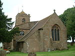 More images |
| Church of Saint Alphege | Solihull | Church | 14th century | 5 December 1949 | SP1533079287 52°24′41″N 1°46′34″W / 52.411373°N 1.776056°W / 52.411373; -1.776056 (Church of Saint Alphege) | 1076693 |  More images |
| Church of Saint John the Baptist, Saint Lawrence and Saint Anne | Knowle | Church | 15th century | 5 December 1949 | SP1823876734 52°23′18″N 1°44′00″W / 52.388333°N 1.733443°W / 52.388333; -1.733443 (Church of Saint John the Baptist, Saint Lawrence and Saint Anne) | 1203309 |  More images |
| Grimshaw Hall | Knowle | Country House | Early 17th century | 5 December 1949 | SP1842877470 52°23′42″N 1°43′50″W / 52.394943°N 1.730611°W / 52.394943; -1.730611 (Grimshaw Hall) | 1076714 | Upload Photo |
| 936 Warwick Road | Solihull | House | Unknown | 17 September 1974 | SP1640878855 52°24′27″N 1°45′37″W / 52.407458°N 1.760229°W / 52.407458; -1.760229 (936 Warwick Road) | 1203586 | Upload Photo |
See also
Notes
- ^ a b c d e The date given is the date used by Historic England as significant for the initial building or that of an important part in the structure's description.
- ^ a b c d e Sometimes known as OSGB36, the grid reference is based on the British national grid reference system used by the Ordnance Survey.
- ^ a b c d e The "List Entry Number" is a unique number assigned to each listed building and scheduled monument by Historic England.
References
National Heritage List for England
- v
- t
- e
- Bedfordshire
- Berkshire
- Bristol
- Buckinghamshire
- Cambridgeshire
- Cheshire
- Cornwall
- Cumbria
- Derbyshire
- Devon
- Dorset
- Durham
- East Sussex
- East Riding of Yorkshire
- Essex
- Gloucestershire
- Greater London
- Greater Manchester
- Hampshire
- Herefordshire
- Hertfordshire
- Isle of Wight
- Kent
- Lancashire
- Leicestershire
- Lincolnshire
- Merseyside
- Norfolk
- North Yorkshire
- Northamptonshire
- Northumberland
- Nottinghamshire
- Oxfordshire
- Rutland
- Shropshire
- Somerset
- South Yorkshire
- Staffordshire
- Suffolk
- Surrey
- Tyne and Wear
- Warwickshire
- West Midlands
- West Sussex
- West Yorkshire
- Wiltshire
- Worcestershire
- Babergh
- Bath and North East Somerset
- Bradford
- Brighton and Hove
- Broadland
- Cheltenham
- Cheshire East
- Cheshire West and Chester
- Cotswold
- Craven
- Dartford
- Dover
- Forest Heath
- Forest of Dean
- Ipswich
- Maidstone
- Mendip
- Mid Suffolk
- North Somerset
- Sedgemoor
- South Gloucestershire
- South Somerset
- St Edmundsbury
- Stroud
- Suffolk Coastal
- Taunton Deane
- Tewkesbury
- Waveney
- West Somerset
- Churches
- War memorials
- 20th century


