Gweal, Isles of Scilly
49°57′12″N 6°22′12″W / 49.9533°N 6.3700°W / 49.9533; -6.3700
United Kingdom
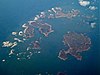
Gweal (/ɡwiːl/ GWEEL; Cornish: Gwydhyel, lit. 'place of trees')[1] is one of the Isles of Scilly. It is the largest of the seven Norrard Rocks due west of Bryher. The name perhaps refers back to a time before most of the islands' area was inundated. This island also includes several tombs.
References
 Cornwall portal

- ^ "Akademi Kernewek - Henwyn Tyller".
- Weatherhill, Craig Cornish Placenames and Language
- Ordnance Survey One-inch Map of Great Britain; Land's End, sheet 190. 1961
- v
- t
- e
Isles of Scilly
- St Mary's
- St Agnes (and Gugh)
- Bryher
- Tresco
- St Martin's
- St Mary's: Hugh Town, Holy Vale, Longstone, Maypole, Normandy, Old Town, Pelistry, Porthloo, Rocky Hill, Telegraph and Trenoweth
- St Martin's: Higher Town, Middle Town and Lower Town
- St Agnes: Middle Town
- Tresco: New Grimsby and Old Grimsby
- Environment
- History
- People
- Transport
 | This article about a location in the Isles of Scilly, Cornwall is a stub. You can help Wikipedia by expanding it. |
- v
- t
- e


