Lamerd County
County in Fars province, Iran
County in Fars, Iran
Lamerd County Persian: شهرستان لامرد | |
|---|---|
County | |
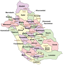 Location of Lamerd County in Fars province (bottom, yellow) | |
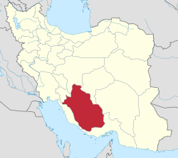 Location of Fars province in Iran | |
| Coordinates: 27°32′N 53°17′E / 27.533°N 53.283°E / 27.533; 53.283[1] | |
| Country | Iran |
| Province | Fars |
| Capital | Lamerd |
| Districts | Central, Alamarvdasht, Chah Varz, Eshkanan, Kheyrgu |
| Population (2016)[2] | |
| • Total | 91,782 |
| Time zone | UTC+3:30 (IRST) |
| Lamerd County can be found at GEOnet Names Server, at this link, by opening the Advanced Search box, entering "9206556" in the "Unique Feature Id" form, and clicking on "Search Database". | |
Lamerd County (Persian: شهرستان لامرد) is in Fars province, Iran. Its capital is the city of Lamerd.[3]
History
After the 2011 census, Chah Varz Rural District was separated from the Central District in the formation of Chah Varz District, which was divided into two rural districts, including the new Sheykh Amer Rural District.[4]
After the 2016 census, Kahnuyeh Rural District was established in Alamarvdasht District. Kheyrgu Rural District was separated from it in the establishment of Kheyrgu District, which was divided into two rural districts, including the new Kamali Rural District.[5] The villages of Chah Varz[6] and Kheyrgu[7] were elevated to city status.
Demographics
Ethnicity
Lamerd was historically part of the region of Irahistan. The people of Lamerd are known as the Achomi people.[8][9][10]
Population
At the time of the 2006 census, the county's population was 76,971 in 16,602 households.[11] The following census in 2011 counted 83,916 people in 21,210 households.[12] The 2016 census measured the population of the county as 91,782 in 25,837 households.[2]
Administrative divisions
Lamerd County's population history and administrative structure over three consecutive censuses are shown in the following table.
| Administrative Divisions | 2006[11] | 2011[12] | 2016[2] |
|---|---|---|---|
| Central District | 43,371 | 46,933 | 44,066 |
| Chah Varz RD | 7,985 | 6,788 | |
| Howmeh RD | 4,087 | 4,186 | 3,733 |
| Sigar RD | 9,934 | 10,828 | 10,953 |
| Lamerd (city) | 21,365 | 25,131 | 29,380 |
| Alamarvdasht District | 14,915 | 16,902 | 19,190 |
| Alamarvdasht RD | 5,154 | 6,050 | 6,511 |
| Kahnuyeh RD[a] | |||
| Kheyrgu RD | 6,259 | 6,757 | 8,611 |
| Alamarvdasht (city)[b] | 3,502 | 4,095 | 4,068 |
| Chah Varz District | 7,010 | ||
| Chah Varz RD | 4,181 | ||
| Sheykh Amer RD | 2,829 | ||
| Chah Varz (city)[c] | |||
| Eshkanan District | 18,685 | 20,058 | 21,508 |
| Eshkanan RD | 3,813 | 4,183 | 4,138 |
| Kal RD | 4,562 | 4,724 | 5,076 |
| Ahel (city) | 2,797 | 2,940 | 3,179 |
| Eshkanan (city) | 7,513 | 8,211 | 9,115 |
| Kheyrgu District[a] | |||
| Kamali RD[a] | |||
| Kheyrgu RD | |||
| Kheyrgu (city)[d] | |||
| Total | 76,971 | 83,916 | 91,782 |
| RD = Rural District | |||
See also
![]() Media related to Lamerd County at Wikimedia Commons
Media related to Lamerd County at Wikimedia Commons
Notes
References
- ^ OpenStreetMap contributors (24 September 2023). "Lamerd County" (Map). OpenStreetMap (in Persian). Retrieved 24 September 2023.
- ^ a b c "Census of the Islamic Republic of Iran, 1395 (2016)". AMAR (in Persian). The Statistical Center of Iran. p. 07. Archived from the original (Excel) on 6 April 2022. Retrieved 19 December 2022.
- ^ Habibi, Hassan (24 August 1368). "Creation and establishment of Lamard city with the center of Lamard city in the citizenship of Fars province". Lamtakam (in Persian). Ministry of Interior, Council of Ministers. Archived from the original on 9 December 2023. Retrieved 9 December 2023.
- ^ Rahimi, Mohammadreza (14 December 2013). "Letter of approval regarding country divisions of Lamerd County, Fars province". Research Center of the System of Laws of the Islamic Council of the Farabi Library (in Persian). Ministry of Interior, Political and Defense Commission. Archived from the original on 5 March 2014. Retrieved 21 November 2023.
- ^ a b Jahangiri, Ishaq (26 May 2019). "Letter of approval regarding country divisions in Lamerd County of Fars province". Qavanin (in Persian). Ministry of Interior, Council of Ministers. Archived from the original on 24 September 2023. Retrieved 24 September 2023.
- ^ a b Fazli, Abdolreza Rahmani (21 June 1369). "The approvals of the Ministry of Interior regarding the transformation of villages in the center of the district into cities". Lamtakam (in Persian). Ministry of Interior, Council of Ministers. Archived from the original on 7 December 2023. Retrieved 7 December 2023.
- ^ a b "About Lamerd: Geographical location, historical background and industrial and welfare facilities of Lamerd County". Islamic Parliament Research Center (in Persian). Lamerd Municipality. Archived from the original on 6 July 2022. Retrieved 20 April 2024.
- ^ Mehran (2 March 2023). "كتاب تاريخ جنوب فارس لارستان وبستك" (in Arabic).
- ^ khodo mania (27 April 2023). "كتاب تاريخ جنوب فارس لارستان وبستك" (in Arabic).
- ^ ABO and Rh blood groups distribution in the populations of Larestan and Lamerd, Fars province Iran. Iranian Journal of Public Health 1996.
- ^ a b "Census of the Islamic Republic of Iran, 1385 (2006)". AMAR (in Persian). The Statistical Center of Iran. p. 07. Archived from the original (Excel) on 20 September 2011. Retrieved 25 September 2022.
- ^ a b "Census of the Islamic Republic of Iran, 1390 (2011)". Syracuse University (in Persian). The Statistical Center of Iran. p. 07. Archived from the original (Excel) on 16 January 2023. Retrieved 19 December 2022.
- ^ Habibi, Hassan (28 May 1375). "The transformation of Chah Ayni village, the center of Alamarvdasht District of Lamerd County, into Alamarvdasht city". Lamtakam (in Persian). Ministry of Interior, Political-Defense Commission of the Government Council. Archived from the original on 20 April 2024. Retrieved 20 April 2024.
Authority control databases | |
|---|---|
| International |
|
| National |
|

 Lamerd County Lamerd County | |||||||||||||||||||||||||||||||||||||||||
|---|---|---|---|---|---|---|---|---|---|---|---|---|---|---|---|---|---|---|---|---|---|---|---|---|---|---|---|---|---|---|---|---|---|---|---|---|---|---|---|---|---|
| Capital | |||||||||||||||||||||||||||||||||||||||||
| Districts |
| ||||||||||||||||||||||||||||||||||||||||


