Rostam County
County in Fars province, Iran
County in Fars, Iran
Rostam County Persian: شهرستان رستم | |
|---|---|
County | |
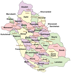 Location of Rostam County in Fars province (top left, green) | |
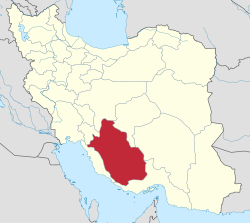 Location of Fars province in Iran | |
| Coordinates: 30°27′N 51°20′E / 30.450°N 51.333°E / 30.450; 51.333[1] | |
| Country |  Iran Iran |
| Province | Fars |
| Capital | Masiri |
| Districts | Central, Sorna |
| Population (2016)[2] | |
| • Total | 44,386 |
| Time zone | UTC+3:30 (IRST) |
Rostam County (Persian: شهرستان رستم) is in Fars province, Iran. Its capital is the city of Masiri.[3]
History
After the 2006 National Census, Rostam District was separated from Mamasani County in the establishment of Rostam County, which was divided into two districts of two rural districts each, with Masiri as its capital and only city at the time. After the 2011 census, three villages merged to form the new city of Kupon.[3]
Demographics
Population
At the time of the 2011 census, the county's population was 46,851 people in 11,902 households.[4] The 2016 census measured the population of the county as 44,386 in 12,668 households.[2]
Administrative divisions
Rostam County's population history and administrative structure over two consecutive censuses are shown in the following table.
| Administrative Divisions | 2011[4] | 2016[2] |
|---|---|---|
| Central District | 28,101 | 27,079 |
| Rostam-e Do RD | 7,206 | 6,514 |
| Rostam-e Yek RD | 15,065 | 11,534 |
| Masiri (city) | 5,830 | 9,031 |
| Sorna District | 18,403 | 17,282 |
| Poshtkuh-e Rostam RD[a] | 8,906 | 7,811 |
| Rostam-e Seh RD | 9,497 | 6,234 |
| Kupon (city)[b] | 3,237 | |
| Total | 46,851 | 44,386 |
| RD = Rural District | ||
See also
![]() Media related to Rostam County at Wikimedia Commons
Media related to Rostam County at Wikimedia Commons
 Iran portal
Notes
References
- ^ OpenStreetMap contributors (28 September 2023). "Rostam County" (Map). OpenStreetMap (in Persian). Retrieved 28 September 2023.
- ^ a b c "Census of the Islamic Republic of Iran, 1395 (2016)". AMAR (in Persian). The Statistical Center of Iran. p. 07. Archived from the original (Excel) on 6 April 2022. Retrieved 19 December 2022.
- ^ a b c Davoudi, Parviz (7 January 1387). "Letter of approval regarding the reforms of country divisions in Fars province". Qavanin (in Persian). Ministry of Interior, Council of Ministers. Archived from the original on 9 October 2021. Retrieved 28 September 2023.
- ^ a b "Census of the Islamic Republic of Iran, 1390 (2011)". Syracuse University (in Persian). The Statistical Center of Iran. p. 07. Archived from the original (Excel) on 16 January 2023. Retrieved 19 December 2022.
- ^ Habibi, Hassan (25 June 1371). "Approval of reforms in the rural districts of Fars province". Lamtakam (in Persian). Ministry of Interior, Defense Political Commission of the Government Council. Archived from the original on 17 April 2024. Retrieved 17 April 2024.
- v
- t
- e
Fars province, Iran

and cities
- Afif-Abad Garden
- Amir's dam
- Arg of Karim Khan
- Barmdelak lagoon
- Bishapur
- Delgosha Garden
- Eram Garden
- Istakhr
- Ghal'eh Dokhtar
- Ka'ba-ye Zartosht
- Kazerun fire temple
- Lake Parishan
- Naqsh-e Rajab
- Naqsh-e Rustam
- Palace of Ardashir
- Sangtarashan cave
- Pars Museum
- Pasargadae
- Persepolis
- Qavam House
- Qur'an Gate
- Saadi's mausoleum
- Sarvestan Sassanian palace
- Shah Cheragh
- Colossal Statue of Shapur I in Shapur cave
- Tangeh Bolaghi
- Tomb of Ali ibn Hamzah, Shiraz
- Hāfezieh
- Tomb of Seyed Alaeddin Husayn
- Tounbbot
- Vakil Bath
- Vakil Bazaar
- Vakil Mosque


