List of State Register of Heritage Places in the City of Stirling
Map all coordinates using OpenStreetMap
Download coordinates as:
- KML
- GPX (all coordinates)
- GPX (primary coordinates)
- GPX (secondary coordinates)
The State Register of Heritage Places is maintained by the Heritage Council of Western Australia. As of 2024[update], 641 places are heritage-listed in the City of Stirling,[1] of which 20 are on the State Register of Heritage Places.[2]
List
The Western Australian State Register of Heritage Places, as of 2024[update], lists the following 20 state registered places within the City of Stirling:
| Place name | Place # | Street number & name | Suburb or town | Co-ordinates | Notes & former names | Photo |
|---|---|---|---|---|---|---|
| Beach House, Trigg Island | 2150 | 352 West Coast Drive | Trigg | 31°52′35″S 115°45′10″E / 31.876404°S 115.752653°E / -31.876404; 115.752653 (Beach House) | 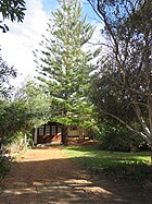 | |
| Astor Theatre | 2425 | 659 Beaufort Street | Mount Lawley | 31°56′03″S 115°52′19″E / 31.934086°S 115.872058°E / -31.934086; 115.872058 (Astor Theatre) | Lyceum Theatre, State Theatre, Astor Cinema | 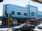 |
| Chapel of St Michael and All Angels | 2430 | 31 Lawley Crescent | Mount Lawley | 31°55′53″S 115°52′33″E / 31.931299°S 115.875820°E / -31.931299; 115.875820 (Chapel of St Michael and All Angels) | Perth College Chapel |  |
| Windsor Hall | 3320 | 36 Queens Crescent | Mount Lawley | 31°55′56″S 115°52′31″E / 31.932316°S 115.875416°E / -31.932316; 115.875416 (Windsor Hall) | 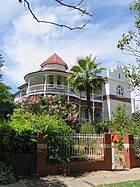 | |
| Cottage, Old Balcatta Road | 3442 | 139 Balcatta Road | Balcatta | 31°51′30″S 115°47′38″E / 31.858323°S 115.793990°E / -31.858323; 115.793990 (Cottage, Old Balcatta Road) | Daviot Park, Bestry Cottage, Duffy Cottage | |
| Herdsman Lake Settlers Cottage | 3464 | 180 Pearson Street | Churchlands | 31°55′08″S 115°47′40″E / 31.918868°S 115.794484°E / -31.918868; 115.794484 (Herdsman Lake Settlers Cottage) | Gava Cottage |  |
| Mount Lawley Tennis Club | 4252 | Rookwood Street | Mount Lawley | 31°55′52″S 115°52′14″E / 31.931021°S 115.870555°E / -31.931021; 115.870555 (Mount Lawley Tennis Club) |  | |
| Beaucott Building | 6185 | 654 Beaufort Street | Mount Lawley | 31°56′04″S 115°52′21″E / 31.934425°S 115.872445°E / -31.934425; 115.872445 (Beaucott Building) | 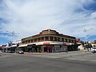 | |
| Inglewood Police Station | 6655 | 867 Beaufort Street | Inglewood | 31°55′20″S 115°53′04″E / 31.922180°S 115.884556°E / -31.922180; 115.884556 (Inglewood Police Station) | ||
| Annesley | 8035 | 49-51 Lawley Crescent | Mount Lawley | 31°55′47″S 115°52′25″E / 31.929597°S 115.873497°E / -31.929597; 115.873497 (Annesley) | Annesley Nursing Home, Annesley Rest Home, Annesley Private Hospital | 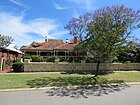 |
| Osborne Primary School | 8802 | 155 Albert Street | Osborne Park | 31°53′59″S 115°49′31″E / 31.899591°S 115.825373°E / -31.899591; 115.825373 (Osborne Primary School) | ||
| Balcatta Senior High School | 9812 | 31 Poincaire Street | Balcatta | 31°52′32″S 115°48′46″E / 31.875556°S 115.812778°E / -31.875556; 115.812778 (Balcatta Senior High School) | Balcatta High School |  |
| Cooinda House, Mount Lawley | 9818 | 24 Queens Crescent | Mount Lawley | 31°55′57″S 115°52′37″E / 31.932626°S 115.876908°E / -31.932626; 115.876908 (Cooinda House, Mount Lawley) | Cooinda Education an Employment Hostel, Cooinda Hostel for Aboriginal Girls | 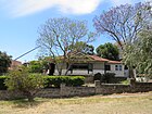 |
| Briggs Kiln Carine | 9842 | Reid Highway | Carine | 31°51′26″S 115°47′46″E / 31.857305°S 115.796101°E / -31.857305; 115.796101 (Briggs Kiln Carine) | Old Lime Kiln |  |
| Marsala House, Dianella | 9917 | 38 Sycamore Rise | Dianella | 31°52′50″S 115°51′52″E / 31.880480°S 115.864531°E / -31.880480; 115.864531 (Marsala House) | Dianella's Disco House | 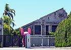 |
| Memorial Gardens & Recreation Reserve, Mount Lawley | 14769 | Lot 6 Queens Crescent | Mount Lawley | 31°55′52″S 115°52′15″E / 31.931080°S 115.870929°E / -31.931080; 115.870929 (Memorial Gardens & Recreation Reserve, Mount Lawley) | Mount Lawley Bowling Club & War Memorial, Mount Lawley Tennis Club, Mount Lawley Croquet Club | 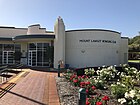 |
| War Memorial | 16608 | Corner Clifton & Queens Crescent | Mount Lawley | 31°55′49″S 115°52′15″E / 31.930233°S 115.870801°E / -31.930233; 115.870801 (War Memorial) |  | |
| Scarborough Clock Tower | 16764 | Intersection The Esplanade & Scarborough Beach Road | Scarborough | 31°53′40″S 115°45′23″E / 31.894404°S 115.756257°E / -31.894404; 115.756257 (Scarborough Clock Tower) | The Rotary Clock Tower of Scarborough Beach |  |
| Inglewood Police Quarters | 19453 | 867 Beaufort Street | Inglewood | 31°55′20″S 115°53′04″E / 31.922180°S 115.884556°E / -31.922180; 115.884556 (Inglewood Police Station) | ||
| Inglewood Police Station & Police Quarters (former) | 19833 | 867 Beaufort Street | Inglewood | 31°55′20″S 115°53′04″E / 31.922180°S 115.884556°E / -31.922180; 115.884556 (Inglewood Police Station) |
References
- v
- t
- e
Heritage places of Western Australia by local government area
| Overview | |
|---|---|
| Cities | |
| Towns | |
| Shires | |
| Islands |
- Beverley
- Brookton†
- Bruce Rock
- Chittering
- Corrigin
- Cuballing
- Cunderdin
- Dalwallinu
- Dandaragan†
- Dowerin†
- Dumbleyung†
- Gingin
- Goomalling
- Kellerberrin
- Kondinin
- Koorda†
- Kulin
- Lake Grace
- Merredin
- Moora
- Mount Marshall†
- Mukinbudin†
- Narembeen
- Narrogin
- Northam
- Nungarin
- Pingelly
- Quairading
- Tammin†
- Toodyay
- Trayning
- Victoria Plains
- Wagin
- Wandering†
- West Arthur
- Westonia
- Wickepin
- Williams
- Wongan-Ballidu
- Wyalkatchem
- Yilgarn
- York (Town of York • Shire of York)
| Organisations | |
|---|---|
| Register |
| Current |
|
|---|---|
| Former | |
^† Denotes LGA without State Heritage Listed Places | |


