List of State Register of Heritage Places in the Shire of Kellerberrin
List of heritage sites in Western Australia
Map all coordinates using OpenStreetMap
Download coordinates as:
- KML
- GPX (all coordinates)
- GPX (primary coordinates)
- GPX (secondary coordinates)
The State Register of Heritage Places is maintained by the Heritage Council of Western Australia. As of 2023[update], 57 places are heritage-listed in the Shire of Kellerberrin,[1] of which six are on the State Register of Heritage Places.[2]
List
The Western Australian State Register of Heritage Places, as of 2023[update], lists the following six state registered places within the Shire of Kellerberrin:
| Place name | Place # | Street number | Street name | Suburb or town | Co-ordinates | Notes & former names | Photo |
|---|---|---|---|---|---|---|---|
| Agricultural Hall (former), Kellerberrin | 1369 | Corner | Leake & Bedford Street | Kellerberrin | 31°37′56″S 117°43′15″E / 31.632163°S 117.720883°E / -31.632163; 117.720883 (Agricultural Hall (former), Kellerberrin) | District Museum, Kellerberrin Folk Museum |  |
| Kellerberrin Post Office & Residence | 1372 | 58 | Massingham Street | Kellerberrin | 31°38′03″S 117°43′07″E / 31.634064°S 117.718689°E / -31.634064; 117.718689 (Kellerberrin Post Office & Residence) |  | |
| Kellerberrin Fire Station | 1379 | 4 | Ripper Street | Kellerberrin | 31°38′03″S 117°43′19″E / 31.6342°S 117.72198°E / -31.6342; 117.72198 (Kellerberrin Fire Station) |  | |
| Hillview House Group | 4045 | 124 | Massingham Street | Kellerberrin | 31°38′06″S 117°42′35″E / 31.635071°S 117.709834°E / -31.635071; 117.709834 (Hillview House Group) | ||
| Djuringe Mooranoppin, Kellerberrin | 11888 | Corner | Goldfields & Mission Roads | Kellerberrin | 31°35′39″S 117°46′21″E / 31.5941°S 117.7725°E / -31.5941; 117.7725 (Djuringe Mooranoppin) | Djuringe Aboriginal Mission and Reserve (former), Old Jiriny Mission, Woolundra Aboriginal Mission | |
| Goldfields Water Supply Scheme | 16610 | Listed under the Coolgardie, Cunderdin, Kellerberrin, Kalgoorlie–Boulder, Merredin, Mundaring, Northam, Tammin and Yilgarn State Heritage lists | Stretches from Mundaring Weir in Perth to the Eastern Goldfields, particularly Coolgardie and Kalgoorlie | 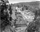 |
References
- ^ "Shire of Kellerberrin Heritage Places". inherit.stateheritage.wa.gov.au. Heritage Council of Western Australia. Retrieved 16 February 2023.
- ^ "Shire of Kellerberrin State Register of Heritage Places". inherit.stateheritage.wa.gov.au. Heritage Council of Western Australia. Retrieved 16 February 2023.
- v
- t
- e
Heritage places of Western Australia by local government area
| Overview | |
|---|---|
| Cities | |
| Towns | |
| Shires | |
| Islands |
- Beverley
- Brookton†
- Bruce Rock
- Chittering
- Corrigin
- Cuballing
- Cunderdin
- Dalwallinu
- Dandaragan†
- Dowerin†
- Dumbleyung†
- Gingin
- Goomalling
- Kellerberrin
- Kondinin
- Koorda†
- Kulin
- Lake Grace
- Merredin
- Moora
- Mount Marshall†
- Mukinbudin†
- Narembeen
- Narrogin
- Northam
- Nungarin
- Pingelly
- Quairading
- Tammin†
- Toodyay
- Trayning
- Victoria Plains
- Wagin
- Wandering†
- West Arthur
- Westonia
- Wickepin
- Williams
- Wongan-Ballidu
- Wyalkatchem
- Yilgarn
- York (Town of York • Shire of York)
| Organisations | |
|---|---|
| Register |
| Current |
|
|---|---|
| Former | |
^† Denotes LGA without State Heritage Listed Places | |


