List of lighthouses in Oregon
This is a list of current and former lighthouses in Oregon.
Map all coordinates using OpenStreetMap
Download coordinates as:
- KML
- GPX (all coordinates)
- GPX (primary coordinates)
- GPX (secondary coordinates)
| Name | Image | Location | Coordinates | Year first lit | Automated | Year deactivated | Current Lens | Height |
|---|---|---|---|---|---|---|---|---|
| Cape Arago Light |  | Coos Bay | 43°20′28″N 124°22′32″W / 43.34123°N 124.37543°W / 43.34123; -124.37543 (Cape Arago Light) | 1866 (First) 1934 (Current) | 1966 | 2006 (Now tribal land) | None | 044 44 ft (13 m) |
| Cape Blanco Light |  | Port Orford | 42°50′12″N 124°33′48″W / 42.8365897°N 124.5633023°W / 42.8365897; -124.5633023 (Cape Blanco Light) | 1870 | 1980 | Active | Second-order Fresnel | 059 59 ft (18 m) |
| Cape Meares Light | 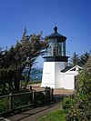 | Oceanside (Cape Meares) | 45°29′11.6″N 123°58′42.2″W / 45.486556°N 123.978389°W / 45.486556; -123.978389 (Cape Meares Light) | 1890[1] | Never (Replaced in 1963) | 1963 (Replacement light deactivated in 2014.[2]) | First-order Fresnel | 038 38 ft (12 m)[3] |
| Cleft of the Rock Light |  | Yachats | 44°17′26″N 124°06′39″W / 44.290479°N 124.110773°W / 44.290479; -124.110773 (Cleft of the Rock Light) | 1976[4] | Always | Active | Fourth-order Fresnel | 034 34 ft (10 m) |
| Coquille River Light |  | Bandon | 43°07′26″N 124°25′27″W / 43.123911°N 124.424222°W / 43.123911; -124.424222 (Coquille River Light) | 1896 | Never (Relit in 1991) | 1939 | Decorative | 040 40 ft (12 m) |
| Desdemona Sands Light |  | Astoria | 46°13′31″N 123°57′13″W / 46.22528°N 123.95361°W / 46.22528; -123.95361[5] | 1901 | 1934 | 1965 (Demolished) | None | 048 48 ft (15 m) |
| Heceta Head Light |  | Florence | 44°08′15″N 124°07′40″W / 44.13737°N 124.127835°W / 44.13737; -124.127835 (Heceta Head Light) | 1894 | 1963 | Active | First-order Fresnel | 056 56 ft (17 m) |
| Pelican Bay Light (aka: Port of Brookings Light[6] | Brookings | 42°02′30″N 124°15′46″W / 42.04175°N 124.26279°W / 42.04175; -124.26279 (Port of Brookings Light) | 1997 (Private light) | Always | Active | Unknown | 035 35 ft (11 m) | |
| Point Adams Light | Astoria | 46°11′18″N 123°58′40″W / 46.188333°N 123.977778°W / 46.188333; -123.977778 (Point Adams Light (former)) | 1875 | Always | 1899 (Demolished in 1912) | None | 049 49 ft (15 m) | |
| Tillamook Rock Light |  | Seaside (Tillamook Head) | 45°56′15″N 124°01′08″W / 45.9375°N 124.019°W / 45.9375; -124.019 (Tillamook Rock Light) | 1881[7] | Never | 1957[8] | None | 062 62 ft (19 m) |
| Umpqua River Light |  | Winchester Bay | 43°39′44″N 124°11′55″W / 43.662291°N 124.198476°W / 43.662291; -124.198476 (Umpqua River Light) | 1857 (First) 1894 (Current) | 1966 | Active | First-order Fresnel | 061 61 ft (19 m) |
| Warrior Rock Light | 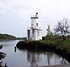 | Sauvie Island | 45°50′55″N 122°47′18″W / 45.84858°N 122.78835°W / 45.84858; -122.78835 (Warrior Rock Light) | 1877 (First) 1970s (Current) | 1930 | Active | Unknown | 025 25 ft (7.6 m) |
| Willamette River Light |  | Portland | 45°39′11″N 122°45′47″W / 45.65301°N 122.76300°W / 45.65301; -122.76300 | 1895 | 1935 | 1950s (Burned down) | None | Unknown |
| Yaquina Bay Light |  | Newport | 44°37′27″N 124°03′46″W / 44.62415°N 124.06290°W / 44.62415; -124.06290 (Yaquina Bay Light) | 1871 | 1996 (Relit) | Active (Inactive: 1874–1996) | 250mm | 051 51 ft (16 m) |
| Yaquina Head Light |  | Newport | 44°40′36.4″N 124°4′45.9″W / 44.676778°N 124.079417°W / 44.676778; -124.079417 (Yaquina Head Light) | 1873[9] | 1966[9] | Active | First-order Fresnel | 093 93 ft (28 m) |
See also
 Engineering portal
 Oregon portal


References
- ^ "Historic Light Station Information & Photography: Oregon". U.S. Coast Guard. Retrieved November 20, 2014.
- ^ "Weather or Not: Go Fly A Kite - www.newslincolncounty.com June 28, 2014". Archived from the original on November 29, 2014. Retrieved January 10, 2018.
- ^ "Oregon Coast Lighthouses" (PDF). Oregon Parks and Recreation Department. p. 2. Archived from the original (PDF) on December 28, 2014. Retrieved January 2, 2015.
- ^ Young, Don; Young, Marjorie (2009). Adventure Guide to the Pacific Northwest. Edison, New Jersey: Hunter Publishing. p. 107. ISBN 978-1-58843-131-8.
- ^ "Desdemona Sands Light". Placenames.com. Archived from the original on 2012-02-15. Retrieved 2008-11-23.
- ^ "Oregon Almanac: Hydropower Projects to State Motto". Oregon Blue Book. Oregon Secretary of State. Retrieved November 20, 2014.
- ^ Cowan, Ron (April 30, 2005). "Loud past, quiet future". Statesman Journal. Salem, Oregon. Archived from the original on February 3, 2013. Retrieved November 11, 2014.
- ^ Yardley, William (October 24, 2007). "Terrible Tillie, Where the Departed Rest Not Quite in Peace". The New York Times. Retrieved November 11, 2014.
- ^ a b "Yaquina Head Lighthouse". Bureau of Land Management. Archived from the original on May 22, 2021. Retrieved November 11, 2014.
External links
Wikimedia Commons has media related to Lighthouses in Oregon.
- Illustrated map Archived 2013-10-22 at the Wayback Machine showing location, range, photos, height, visiting hours, etc.
- v
- t
- e
- Alabama
- Alaska
- California
- Connecticut
- Delaware
- Florida
- Georgia
- Hawaii
- Illinois and Indiana
- Louisiana
- Maine
- Maryland
- Massachusetts
- Michigan
- Minnesota
- Mississippi
- Nebraska
- New Hampshire
- New Jersey
- New York
- North Carolina
- Ohio
- Oregon
- Pennsylvania
- Rhode Island
- South Carolina
- Texas
- Vermont
- Virginia
- Washington
- Wisconsin


