List of lighthouses in California
There are several lighthouses in the U.S. state of California, including a few listed on the National Register of Historic Places.
Lighthouse Friends (California)
| Name | Image | Location | Coordinates | Year first lit | Automated | Year deactivated | Current Lens | Focal Height |
|---|---|---|---|---|---|---|---|---|
| Alcatraz Island Light | 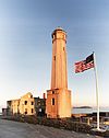 | San Francisco (Alcatraz Island) | 37°49′34.5″N 122°25′19.8″W / 37.826250°N 122.422167°W / 37.826250; -122.422167 | 1854 (First) 1909 (Current) | 1963 | Active | DCB-24 | 214 214 ft (65 m) |
| Anacapa Island Light |  | Anacapa Island | 34°00′57″N 119°21′34″W / 34.015827°N 119.359548°W / 34.015827; -119.359548 | 1912 (First) 1932 (Current) | 1967[1] | Active | DCB-24 | 277 277 ft (84 m) |
| Ano Nuevo Light | 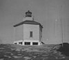 | Año Nuevo Island | 37°06′30″N 122°20′16″W / 37.1083°N 122.3378°W / 37.1083; -122.3378 (Island coordinates) | 1890 (First) 1914 (Last) | Never | 1948 (Cut down in 1976) | None | Unknown |
| Ballast Point Light |  | San Diego (Point Loma) | 32°41′11.0″N 117°13′57.0″W / 32.686389°N 117.232500°W / 32.686389; -117.232500 | 1890 | Never | 1960A (Demolished) | None | Unknown |
| Battery Point Light |  | Crescent City | 41°44′39″N 124°12′11″W / 41.744094°N 124.203099°W / 41.744094; -124.203099 | 1856 | 1953 | Active (Inactive: 1965–1982) | 375mm | 077 77 ft (23 m) |
| Cape Mendocino Light |  | Shelter Cove | 40°26′23.66″N 124°24′21.71″W / 40.4399056°N 124.4060306°W / 40.4399056; -124.4060306 | 1868 | 1951 | 1971B (Replaced) | None | 422 422 ft (129 m) |
| Carquinez Strait Light |  | Vallejo | 38°04′04″N 122°12′50″W / 38.067816°N 122.213832°W / 38.067816; -122.213832 | 1910 | Never | 1951 (Replaced by beacon) | None | 056 56 ft (17 m) |
| East Brother Island Light |  | Richmond | 37°57′48″N 122°26′01″W / 37.963233°N 122.433643°W / 37.963233; -122.433643 | 1874 | 1969 | Active | FA 251 | 061 61 ft (19 m) |
| Farallon Island Light | 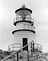 | San Francisco (Farallon Islands) | 37°41′56″N 123°00′06″W / 37.698966°N 123.001651°W / 37.698966; -123.001651 | 1856 | 1972 | Active | VRB-25 | 358 358 ft (109 m) |
| Fort Point Light | 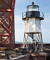 | San Francisco | 37°48′38″N 122°28′38.4″W / 37.81056°N 122.477333°W / 37.81056; -122.477333 | 1855 (First) 1864 (Current) | Never | 1934 (Replaced by bridge) | None | 110 110 ft (34 m) |
| Humboldt Harbor Light | Eureka (Humboldt Bay) | 40°46′7.1″N 124°13′15.7″W / 40.768639°N 124.221028°W / 40.768639; -124.221028 | 1856 | Never | 1892 (Collapsed in 1933) | None | 045 45 ft (14 m) | |
| Lime Point Light |  | San Francisco | 37°49′32″N 122°28′42″W / 37.825447°N 122.478321°W / 37.825447; -122.478321 | 1900 | 1961 | Active | None | 020 20 ft (6.1 m) |
| Lions Lighthouse for Sight | 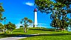 | Long Beach | 33°45′37″N 118°11′39″W / 33.7602334°N 118.1941101°W / 33.7602334; -118.1941101 | 2000[2] | Unknown | Unknown | Unknown | 065.62 65.62 ft (20.00 m)[2] |
| Long Beach Light |  | Long Beach (Port of Long Beach) | 33°43′24″N 118°11′13″W / 33.723237°N 118.186821°W / 33.723237; -118.186821 | 1949 | Always | Active | Unknown | 050 50 ft (15 m) |
| Los Angeles Harbor Light |  | Los Angeles (Port of Los Angeles) | 33°42′31″N 118°15′06″W / 33.70857°N 118.25160°W / 33.70857; -118.25160 | 1913 | 1973 | Active | DCB-24 | 073 73 ft (22 m) |
| Mare Island Light |  | Vallejo (Mare Island) | 38°04′29″N 122°15′02″W / 38.074834°N 122.250464°W / 38.074834; -122.250464 | 1873 | Never | 1917 (Demolished in the 1930s) | None | 076 76 ft (23 m) |
| Mile Rocks Light |  | San Francisco | 37°47′34″N 122°30′37″W / 37.792765°N 122.510366°W / 37.792765; -122.510366 | 1906 | 1966 | Active | DCB-24 | 049 49 ft (15 m) |
| Oakland Harbor Light |  | Oakland | 37°46′53″N 122°14′38″W / 37.781335°N 122.243817°W / 37.781335; -122.243817 | 1890 (First) 1903 (Last) | Never | 1966C | None | Unknown |
| Parkers' Lighthouse | Long Beach | 33°45′36″N 118°11′31″W / 33.7598744°N 118.1920629°W / 33.7598744; -118.1920629 | Unknown | Unknown | Unknown | Unknown | Unknown | |
| Piedras Blancas Light | 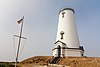 | San Simeon | 35°39′56.3″N 121°17′03.6″W / 35.665639°N 121.284333°W / 35.665639; -121.284333 | 1875 | 1975 | Active | VRB-25 | 142 142 ft (43 m) |
| Pigeon Point Light |  | Half Moon Bay | 37°10′54.3″N 122°23′38.1″W / 37.181750°N 122.393917°W / 37.181750; -122.393917 | 1872 | 1974 | Active | DCB-24 | 148 148 ft (45 m) |
| Point Arena Light |  | Point Arena | 38°57′17.1″N 123°44′25.8″W / 38.954750°N 123.740500°W / 38.954750; -123.740500 | 1870 (First) 1908 (Current) | 1977 | Active | DCB-224 | 155 155 ft (47 m) |
| Point Arguello Light | 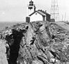 | Lompoc (Point Arguello) | 34°34′37.4″N 120°38′49.9″W / 34.577056°N 120.647194°W / 34.577056; -120.647194 | 1901 (First) 1934 (Last) | 1934 | 1967D | None | 124 124 ft (38 m) |
| Point Blunt Light |  | San Francisco (Angel Island) | 37°51′11.64″N 122°25′9.25″W / 37.8532333°N 122.4192361°W / 37.8532333; -122.4192361 | 1915 (First) 1956 (Current) | 1976 | Active | Unknown | 060 60 ft (18 m) |
| Point Bonita Light |  | San Francisco (Point Bonita) | 37°48′56″N 122°31′46″W / 37.815614°N 122.529578°W / 37.815614; -122.529578 | 1855 (First) 1877 (Current) | 1980 | Active | Second-order Fresnel | 124 124 ft (38 m) |
| Point Cabrillo Light |  | Caspar | 39°20′54.97″N 123°49′34.02″W / 39.3486028°N 123.8261167°W / 39.3486028; -123.8261167 | 1909 | 1973 | Active | Third-order Fresnel | 081 81 ft (25 m) |
| Point Conception Light |  | Lompoc (Point Conception) | 34°26′55.51″N 120°28′14.71″W / 34.4487528°N 120.4707528°W / 34.4487528; -120.4707528 | 1856 (First) 1882 (Current) | 1973 | Active | VRB-25 | 133 133 ft (41 m) |
| Point Diablo Light |  | San Francisco (Golden Gate) | 37°49′13″N 122°29′58″W / 37.820171°N 122.499423°W / 37.820171; -122.499423 | 1923 | Always | Active | Unknown | Unknown |
| Point Fermin Light |  | Los Angeles (San Pedro) | 33°42′20″N 118°17′37″W / 33.705420°N 118.293649°W / 33.705420; -118.293649 | 1874 | Never | 1942 | None | 120 120 ft (37 m) |
| Point Hueneme Light | 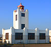 | Port Hueneme | 34°08′43″N 119°12′36″W / 34.145176°N 119.210019°W / 34.145176; -119.210019 | 1874 (First) 1941 (Current) | 1972 | Active | LED | 052 52 ft (16 m) |
| Point Knox Light | San Francisco | — | 1900 | Unknown | 1963 (Demolished) | None | Unknown | |
| Point Loma Light (old) |  | San Diego (Point Loma) | 32°40′19″N 117°14′27″W / 32.671983°N 117.240938°W / 32.671983; -117.240938 | 1855E | Never | 1891 | Third-order Fresnel (Deactivated) | 462 462 ft (141 m) |
| Point Loma Light (new) |  | San Diego (Point Loma) | 32°39′54″N 117°14′33″W / 32.665071°N 117.242621°W / 32.665071; -117.242621 | 1891 | 1973 | Active | VLB-44 | 088 88 ft (27 m) |
| Point Montara Light |  | Montara | 37°32′11″N 122°31′10″W / 37.536503°N 122.519311°W / 37.536503; -122.519311 | 1900 (First) 1928 (Current) | 1970 | Active | FA 251 | 070 70 ft (21 m) |
| Point Pinos Light | 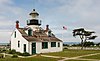 | Pacific Grove | 36°38′00″N 121°56′02″W / 36.633389°N 121.933783°W / 36.633389; -121.933783 | 1855 | 1975 | Active | Third-order Fresnel | 089 89 ft (27 m) |
| Point Reyes Light |  | Point Reyes Station (Point Reyes) | 37°59′44″N 123°01′24″W / 37.995621°N 123.023215°W / 37.995621; -123.023215 | 1870 | 1975 | Active | First-order Fresnel | 265 265 ft (81 m) |
| Point San Luis Light |  | Avila Beach | 35°09′37″N 120°45′39″W / 35.160362°N 120.760882°W / 35.160362; -120.760882 | 1890 | 1974 | 1975D | None | 116 116 ft (35 m) |
| Point Sur Light |  | Carmel-by-the-Sea | 36°18′22.79″N 121°54′05.36″W / 36.3063306°N 121.9014889°W / 36.3063306; -121.9014889 | 1889 | 1972 | Active | DCB-224 | 270 270 ft (82 m) |
| Point Vicente Light |  | Rancho Palos Verdes | 33°44′31″N 118°24′39″W / 33.741867°N 118.410738°W / 33.741867; -118.410738 | 1926 | 1973 | Active | Third-order Fresnel | 155 155 ft (47 m) |
| Punta Gorda Light |  | Petrolia | 40°14′58″N 124°21′01″W / 40.249433°N 124.350220°W / 40.249433; -124.350220 | 1912 | Never | 1951 | None | Unknown |
| Roe Island Light |  | Roe Island | 38°04′04″N 122°01′41″W / 38.067856°N 122.028166°W / 38.067856; -122.028166 | 1891 | Never | 1945 (Later destroyed) | None | 041 41 ft (12 m) |
| Rubicon Point Light |  | South Lake Tahoe | 38°59′45″N 120°05′41″W / 38.99583°N 120.09472°W / 38.99583; -120.09472 | 1919 | Never | 1921 | None | 200 200 ft (61 m) |
| Santa Barbara Light |  | Santa Barbara | 34°23′47″N 119°43′21″W / 34.396320°N 119.722625°W / 34.396320; -119.722625 | 1856 (First) 1928 (Current) | 1928 | Active | Unknown | 142 142 ft (43 m) |
| Santa Cruz Light |  | Santa Cruz | 36°57′05.34″N 122°01′36.36″W / 36.9514833°N 122.0267667°W / 36.9514833; -122.0267667 | 1870 (First) 1967 (Current) | 1941 | Active? | Unknown | 060 60 ft (18 m) |
| Santa Cruz Breakwater Light |  | Santa Cruz (Santa Cruz harbor) | 36°57′38.5″N 122°00′08.0″W / 36.960694°N 122.002222°W / 36.960694; -122.002222 | 1964 (First) 2002 (Current) | Always | Active | Unknown | 060 60 ft (18 m) |
| Southampton Shoal Light | 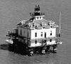 | San Francisco Bay | 37°52′54.981″N 122°24′00.837″W / 37.88193917°N 122.40023250°W / 37.88193917; -122.40023250 | 1905 | Never | 1960 (Moved to yacht club) | None | Unknown |
| St. George Reef Light | 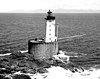 | Crescent City | 41°50′11″N 124°22′33″W / 41.83633°N 124.37587°W / 41.83633; -124.37587 | 1892 | Never | Active (Inactive: 1975–2012) | Unknown | 146 146 ft (45 m) |
| Sugar Pine Point Light | Tahoma | 39°03′41″N 120°06′50″W / 39.061266°N 120.113971°W / 39.061266; -120.113971 | 1921 | Never | 1985D | None | Unknown | |
| Table Bluff Light |  | Table Bluff | 40°41′45.02″N 124°16′26.16″W / 40.6958389°N 124.2739333°W / 40.6958389; -124.2739333 | 1892 | 1953 | 1971 | None | Unknown |
| Trinidad Head Light | 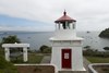 | Trinidad | 41°3′7.0″N 124°9′5.2″W / 41.051944°N 124.151444°W / 41.051944; -124.151444 | 1871 | 1974 | Active | 375mm | 196 196 ft (60 m) |
| Yerba Buena Light | 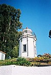 | San Francisco Yerba Buena Island | 37°48′26.27″N 122°21′44.29″W / 37.8072972°N 122.3623028°W / 37.8072972; -122.3623028 | 1875 | 1958 | Active | Unknown | 095 95 ft (29 m) |
Notable Faux Lighthouse
| Name | Image | Location | Year built | Status | Lens used | Height |
|---|---|---|---|---|---|---|
| Passamaquoddy Lighthouse (Used in the 1977 movie Pete's Dragon) | Los Osos[3] | 1976 | torn down after filming[4] | Fresnel Lens (Replica) | 052 52 ft (16 m) |
Notes
- A.^ Ballast Point Light was moved in 1960 to the bell tower which had served as a fog signal building as the 1890 tower had been declared unsafe. The light shone from the top of the bell tower until 1961 when it was replaced by an offshore light.
- B.^ The tower was abandoned in 1971 when the beacon was moved to a nearby modern pole. This light was discontinued in 2013 fifteen years after the old tower was moved to a new spot and restored.
- C.^ Parts of the old structure now have separate owners, today an automated beacon is in active service.
- D.^ Light moved to a pole.
- E.^ Old Point Loma Light was built a few months after the lighthouse at Point Pinos making it the second oldest in the state still standing.
References
- ^ "Anacapa Island Lighthouse". Lighthouse Friends. Retrieved October 8, 2017.
- ^ a b "The Lions Lighthouse for Sight, Long Beach | 1209333 | EMPORIS". Emporis. Archived from the original on July 16, 2018. Retrieved 16 July 2018.
- ^ Pete's Dragon. Bonus Features: Film Facts (DVD). Disney Enterprises (distributed by Buena Vista Home Entertainment).
- ^ Stacy Conradt (March 4, 2016). "12 Brazzle-Dazzle Facts About Pete's Dragon". Mental Floss. Retrieved October 9, 2017.
- v
- t
- e
- Alabama
- Alaska
- California
- Connecticut
- Delaware
- Florida
- Georgia
- Hawaii
- Illinois and Indiana
- Louisiana
- Maine
- Maryland
- Massachusetts
- Michigan
- Minnesota
- Mississippi
- Nebraska
- New Hampshire
- New Jersey
- New York
- North Carolina
- Ohio
- Oregon
- Pennsylvania
- Rhode Island
- South Carolina
- Texas
- Vermont
- Virginia
- Washington
- Wisconsin


