Narraweena, New South Wales
Suburb of Sydney, New South Wales, Australia
| Narraweena Sydney, New South Wales | |||||||||||||||
|---|---|---|---|---|---|---|---|---|---|---|---|---|---|---|---|
 | |||||||||||||||
| Population | 6,608 (2016 census)[1] | ||||||||||||||
| Postcode(s) | 2099 | ||||||||||||||
| Elevation | 78 m (256 ft) | ||||||||||||||
| Location | 18 km (11 mi) north-east of Sydney CBD | ||||||||||||||
| LGA(s) | Northern Beaches Council | ||||||||||||||
| State electorate(s) | Wakehurst | ||||||||||||||
| Federal division(s) |
| ||||||||||||||
| |||||||||||||||
Narraweena is a suburb of northern Sydney, in the state of New South Wales, Australia. Narraweena is 18 kilometres north-east of the Sydney central business district, in the local government area of Northern Beaches Council and is part of the Northern Beaches region.
Narraweena has two primary schools; Narraweena Public School and St John the Apostle Narraweena Catholic School.
History
Narraweena is an Aboriginal name meaning a quiet place in the hills.[citation needed] The suburb developed after World War II, when the land was subdivided, Narraweena Post Office opening on 1 April 1953.[2][3]
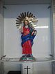
Italian people from Pazzano since the 1980s have organised an annual Santo Salvatore's fiest, with a statue very similar to the original that is taken from the Catholic church of Narraweena around the suburb and back.
Transport
Keolis Downer Northern Beaches operates five bus routes through the suburb of Narraweena:
- 160X: Dee Why to Chatswood[4]
- 166: Frenchs Forest to Manly[5]
- 174X: Narraweena to City Wynyard[6]
- 178: Cromer Heights to Warringah Mall[7]
- 179: Wheeler Heights to Warringah Mall[8]
CDC NSW operates one bus route through the suburb of Narraweena:
- 193: Austlink to Warringah Mall[9]
References
- ^ Australian Bureau of Statistics (27 June 2017). "Narraweena (NSW) (State Suburb)". 2016 Census QuickStats. Retrieved 15 March 2018.

- ^ Premier Postal History. "Post Office List". Premier Postal Auctions. Retrieved 12 June 2012.
- ^ The Book of Sydney Suburbs, Compiled by Frances Pollon, Angus & Robertson Publishers, 1990, Published in Australia ISBN 0-207-14495-8
- ^ "| transportnsw.info". transportnsw.info. Retrieved 1 March 2024.
- ^ "| transportnsw.info". transportnsw.info. Retrieved 1 March 2024.
- ^ "| transportnsw.info". transportnsw.info. Retrieved 1 March 2024.
- ^ "| transportnsw.info". transportnsw.info. Retrieved 1 March 2024.
- ^ "| transportnsw.info". transportnsw.info. Retrieved 1 March 2024.
- ^ "| transportnsw.info". transportnsw.info. Retrieved 1 March 2024.
- v
- t
- e
Suburbs of Northern Beaches Council, Sydney
- Allambie Heights
- Avalon Beach
- Balgowlah
- Balgowlah Heights
- Bayview
- Beacon Hill
- Belrose
- Bilgola Beach
- Bilgola Plateau
- Brookvale
- Church Point
- Clareville
- Clontarf
- Coasters Retreat
- Collaroy
- Collaroy Plateau
- Cottage Point
- Cromer
- Curl Curl
- Currawong Beach
- Davidson
- Dee Why
- Duffys Forest
- Elanora Heights
- Elvina Bay
- Fairlight
- Forestville
- Frenchs Forest
- Freshwater
- Great Mackerel Beach
- Ingleside
- Killarney Heights
- Lovett Bay
- Manly
- Manly Vale
- McCarrs Creek
- Mona Vale
- Morning Bay
- Narrabeen
- Narraweena
- Newport
- North Balgowlah
- North Curl Curl
- North Manly
- North Narrabeen
- Oxford Falls
- Palm Beach
- Queenscliff
- Salt Pan Cove
- Scotland Island
- Seaforth
- Terrey Hills
- Warriewood
- Whale Beach
- Wheeler Heights
33°44′55″S 151°16′04″E / 33.74861°S 151.26778°E / -33.74861; 151.26778
 | This article related to the geography of Sydney is a stub. You can help Wikipedia by expanding it. |
- v
- t
- e


