National Register of Historic Places listings in Bartow County, Georgia
This is a list of properties and districts in Bartow County, Georgia that are listed on the National Register of Historic Places (NRHP).
Map all coordinates using OpenStreetMap
Download coordinates as:
- KML
- GPX (all coordinates)
- GPX (primary coordinates)
- GPX (secondary coordinates)
This National Park Service list is complete through NPS recent listings posted August 16, 2024.[1]
- v
- t
- e
Properties on the National Register of Historic Places in Georgia by county
- Appling
- Atkinson
- Bacon
- Baker
- Baldwin
- Banks
- Barrow
- Bartow
- Ben Hill
- Berrien
- Bibb
- Bleckley
- Brantley
- Brooks
- Bryan
- Bulloch
- Burke
- Butts
- Calhoun
- Camden
- Candler
- Carroll
- Catoosa
- Charlton
- Chatham
- Chattahoochee
- Chattooga
- Cherokee
- Clarke
- Clay
- Clayton
- Clinch
- Cobb
- Coffee
- Colquitt
- Columbia
- Cook
- Coweta
- Crawford
- Crisp
- Dade
- Dawson
- Decatur
- DeKalb
- Dodge
- Dooly
- Dougherty
- Douglas
- Early
- Echols
- Effingham
- Elbert
- Emanuel
- Evans
- Fannin
- Fayette
- Floyd
- Forsyth
- Franklin
- Fulton
- Gilmer
- Glascock
- Glynn
- Gordon
- Grady
- Greene
- Gwinnett
- Habersham
- Hall
- Hancock
- Haralson
- Harris
- Hart
- Heard
- Henry
- Houston
- Irwin
- Jackson
- Jasper
- Jeff Davis
- Jefferson
- Jenkins
- Johnson
- Jones
- Lamar
- Lanier
- Laurens
- Lee
- Liberty
- Lincoln
- Long
- Lowndes
- Lumpkin
- Macon
- Madison
- Marion
- McDuffie
- McIntosh
- Meriwether
- Miller
- Mitchell
- Monroe
- Montgomery
- Morgan
- Murray
- Muscogee
- Newton
- Oconee
- Oglethorpe
- Paulding
- Peach
- Pickens
- Pierce
- Pike
- Polk
- Pulaski
- Putnam
- Quitman
- Rabun
- Randolph
- Richmond
- Rockdale
- Schley
- Screven
- Seminole
- Spalding
- Stephens
- Stewart
- Sumter
- Talbot
- Taliaferro
- Tattnall
- Taylor
- Telfair
- Terrell
- Thomas
- Tift
- Toombs
- Towns
- Treutlen
- Troup
- Turner
- Twiggs
- Union
- Upson
- Walker
- Walton
- Ware
- Warren
- Washington
- Wayne
- Webster
- Wheeler
- White
- Whitfield
- Wilcox
- Wilkes
- Wilkinson
- Worth

Current listings
| [2] | Name on the Register | Image | Date listed[3] | Location | City or town | Description |
|---|---|---|---|---|---|---|
| 1 | Adairsville Historic District |  | December 4, 1987 (#87002043) | Roughly Main St. bounded by King & Elm Sts., & city limits on S & W 34°22′03″N 84°56′03″W / 34.3675°N 84.934167°W / 34.3675; -84.934167 (Adairsville Historic District) | Adairsville | |
| 2 | ATCO-Goodyear Mill and Mill Village Historic District |  | October 21, 2005 (#05001172) | Roughly bounded by Sugar Valley Rd., Cassville Rd. and Pettit Creek, Wingfoot Trail and Litchfield St. 34°10′44″N 84°49′09″W / 34.178889°N 84.819167°W / 34.178889; -84.819167 (ATCO-Goodyear Mill and Mill Village Historic District) | Cartersville | |
| 3 | Bartow County Courthouse |  | September 18, 1980 (#80000971) | Courthouse Sq. 34°09′57″N 84°47′52″W / 34.16592°N 84.79775°W / 34.16592; -84.79775 (Bartow County Courthouse) | Cartersville | |
| 4 | Benham Place |  | January 30, 1998 (#98000030) | 222 Grassdale Rd. 34°12′16″N 84°49′12″W / 34.20454°N 84.8201°W / 34.20454; -84.8201 (Benham Place) | Cartersville | |
| 5 | Cartersville Downtown Historic District |  | November 12, 2014 (#14000904) | Roughly bounded by Church, Gilmer, Leake & Noble Sts. 34°09′55″N 84°47′49″W / 34.165245°N 84.796881°W / 34.165245; -84.796881 (Cartersville Downtown Historic District) | Cartersville | |
| 6 | Cassville Post Office | 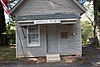 | August 31, 1992 (#92001129) | 1813 Cassville Rd. (Old Dixie Hwy.) 34°14′58″N 84°51′10″W / 34.249444°N 84.852778°W / 34.249444; -84.852778 (Cassville Post Office) | Cassville | |
| 7 | Etowah Mounds | 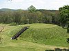 | October 15, 1966 (#66000272) | N bank of Etowah River 34°07′33″N 84°48′29″W / 34.125833°N 84.808056°W / 34.125833; -84.808056 (Etowah Mounds) | Cartersville | A National Historic Landmark and a Georgia state historic site |
| 8 | Etowah Valley District | Upload image | June 30, 1975 (#75000573) | Address Restricted | Cartersville | |
| 9 | Rebecca Latimer Felton House |  | January 31, 1979 (#79000697) | N of Cartersville off U.S. 411 34°12′23″N 84°47′54″W / 34.20628°N 84.79828°W / 34.20628; -84.79828 (Rebecca Latimer Felton House) | Cartersville | No longer there according to satellite view |
| 10 | First Presbyterian Church |  | August 29, 1991 (#91001157) | 183 W. Main St. 34°09′51″N 84°47′59″W / 34.164167°N 84.799722°W / 34.164167; -84.799722 (First Presbyterian Church) | Cartersville | |
| 11 | Grand Theater | 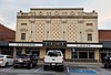 | June 28, 1984 (#84000893) | 2 Wall St. 34°09′59″N 84°47′44″W / 34.166389°N 84.795556°W / 34.166389; -84.795556 (Grand Theater) | Cartersville | |
| 12 | Corra White Harris House, Study, and Chapel |  | July 25, 1997 (#97000249) | 659 Mt. Pleasant Rd., NE. 34°22′15″N 84°45′39″W / 34.37093°N 84.76093°W / 34.37093; -84.76093 (Corra White Harris House, Study, and Chapel) | Rydal | |
| 13 | Sam Jones Memorial United Methodist Church |  | September 5, 1985 (#85001972) | 100 W. Church St. 34°09′59″N 84°47′52″W / 34.16636°N 84.79774°W / 34.16636; -84.79774 (Sam Jones Memorial United Methodist Church) | Cartersville | |
| 14 | Noble Hill School |  | July 2, 1987 (#87001103) | 2361 Frank Harris Pkwy. 34°14′49″N 84°51′31″W / 34.24701°N 84.85849°W / 34.24701; -84.85849 (Noble Hill School) | Cassville | Now used as a museum[4] |
| 15 | North Erwin Street Historic District | 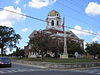 | September 16, 1994 (#94001071) | Jct. of N. Erwin and Cherokee Sts. 34°09′57″N 84°47′50″W / 34.165833°N 84.797222°W / 34.165833; -84.797222 (North Erwin Street Historic District) | Cartersville | |
| 16 | North Wall Street Historic District |  | March 19, 1998 (#98000249) | Roughly bounded by N. Wall, E. Church, and N. Gilmer Sts., and E. Cherokee Ave. 34°10′00″N 84°47′42″W / 34.166667°N 84.795°W / 34.166667; -84.795 (North Wall Street Historic District) | Cartersville | |
| 17 | Old Bartow County Courthouse |  | September 18, 1980 (#80000972) | 4 E. Church St. 34°10′02″N 84°47′45″W / 34.16726°N 84.79591°W / 34.16726; -84.79591 (Old Bartow County Courthouse) | Cartersville | Now the Bartow History Museum |
| 18 | Pine Log Methodist Church, Campground, and Cemetery |  | September 9, 1988 (#86002176) | GA 140, W of US 411 34°20′57″N 84°43′33″W / 34.349167°N 84.725833°W / 34.349167; -84.725833 (Pine Log Methodist Church, Campground, and Cemetery) | Rydal | (See partial description at Rydal, Georgia) |
| 19 | Roselawn |  | January 12, 1973 (#73000607) | 244 Cherokee Ave. 34°09′54″N 84°48′10″W / 34.16513°N 84.80271°W / 34.16513; -84.80271 (Roselawn) | Cartersville | Now a museum |
| 20 | Smith and Douglas Family Houses |  | April 22, 1999 (#99000412) | Mac Johnson Rd. 34°14′03″N 84°50′44″W / 34.2343°N 84.84557°W / 34.2343; -84.84557 (Smith and Douglas Family Houses) | Cassville | |
| 21 | Valley View | Upload image | May 8, 1974 (#74000657) | Euharlee Rd., SW of Cartersville 34°08′23″N 84°52′04″W / 34.139722°N 84.867778°W / 34.139722; -84.867778 (Valley View) | Cartersville |
References
- ^ National Park Service, United States Department of the Interior, "National Register of Historic Places: Weekly List Actions", retrieved August 16, 2024.
- ^ Numbers represent an alphabetical ordering by significant words. Various colorings, defined here, differentiate National Historic Landmarks and historic districts from other NRHP buildings, structures, sites or objects.
- ^ The eight-digit number below each date is the number assigned to each location in the National Register Information System database, which can be viewed by clicking the number.
- ^ "Noble Hill-Wheeler Memorial Center". Retrieved May 2, 2016.
Wikimedia Commons has media related to National Register of Historic Places in Bartow County, Georgia.
| |
|---|---|
| Topics | |
| Lists by state |
|
| Lists by insular areas | |
| Lists by associated state | |
| Other areas | |
| Related | |
| |


