National Register of Historic Places listings in Bourbon County, Kentucky

This is a list of the National Register of Historic Places listings in Bourbon County, Kentucky.
This is intended to be a complete list of the properties and districts on the National Register of Historic Places in Bourbon County, Kentucky, United States. The locations of National Register properties and districts for which the latitude and longitude coordinates are included below, may be seen in a map.[1]
There are 61 properties and districts listed on the National Register in the county.
This National Park Service list is complete through NPS recent listings posted August 16, 2024.[2]
Map all coordinates using OpenStreetMap
Download coordinates as:
- KML
- GPX (all coordinates)
- GPX (primary coordinates)
- GPX (secondary coordinates)
Current listings
| [3] | Name on the Register | Image | Date listed[4] | Location | City or town | Description |
|---|---|---|---|---|---|---|
| 1 | Airy Castle |  | November 7, 1976 (#76000845) | 8 miles northeast of Paris on LaRue Rd. 38°17′44″N 84°16′32″W / 38.295556°N 84.275556°W / 38.295556; -84.275556 (Airy Castle) | Paris | |
| 2 | Jacob Aker Farm | Upload image | February 11, 1993 (#93000050) | 795 Bethlehem Rd. 38°09′56″N 84°15′56″W / 38.165556°N 84.265556°W / 38.165556; -84.265556 (Jacob Aker Farm) | Paris | |
| 3 | Allen-Alexander House |  | July 24, 1975 (#75000735) | Off U.S. Route 68 near its junction with U.S. Route 460 38°13′12″N 84°14′08″W / 38.220000°N 84.235556°W / 38.220000; -84.235556 (Allen-Alexander House) | Paris | |
| 4 | Bayless Quarters | Upload image | June 23, 1983 (#83002556) | Kentucky Route 13 38°14′39″N 84°05′40″W / 38.244167°N 84.0945833°W / 38.244167; -84.0945833 (Bayless Quarters) | North Middletown | |
| 5 | Bourbon County Confederate Monument |  | July 17, 1997 (#97000719) | 0.5 miles northeast of the junction of U.S. Route 460 and Kentucky Route 1678 38°12′10″N 84°15′55″W / 38.202778°N 84.265278°W / 38.202778; -84.265278 (Bourbon County Confederate Monument) | Paris | |
| 6 | Bourbon County Courthouse |  | December 31, 1974 (#74000851) | Courthouse Sq. 38°12′48″N 84°15′00″W / 38.213333°N 84.25°W / 38.213333; -84.25 (Bourbon County Courthouse) | Paris | |
| 7 | Buckner Site (15BB12) | Upload image | January 27, 1983 (#83002557) | Address Restricted | Paris | |
| 8 | Walker Buckner House | 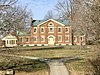 | March 14, 1997 (#97000232) | 1500 Cane Ridge Rd. 38°11′59″N 84°07′57″W / 38.199722°N 84.1325°W / 38.199722; -84.1325 (Walker Buckner House) | Paris | |
| 9 | Cane Ridge Rural Historic District |  | June 25, 2003 (#02001463) | Cane Ridge Rd. 38°12′21″N 84°08′19″W / 38.205833°N 84.138611°W / 38.205833; -84.138611 (Cane Ridge Rural Historic District) | Paris | |
| 10 | Thomas Champ House |  | June 19, 2003 (#03000256) | Lexington and Maysville Rd. 38°15′39″N 84°11′29″W / 38.260833°N 84.191389°W / 38.260833; -84.191389 (Thomas Champ House) | Paris | |
| 11 | Dr. Henry Clay House | Upload image | August 22, 1983 (#83002558) | Off Kentucky Route 227 38°08′18″N 84°13′53″W / 38.138333°N 84.231389°W / 38.138333; -84.231389 (Dr. Henry Clay House) | Paris | |
| 12 | Colville Covered Bridge | 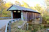 | December 30, 1974 (#74000850) | 4 miles northwest of Millersburg over Hinkston Creek 38°19′29″N 84°12′12″W / 38.324722°N 84.203333°W / 38.324722; -84.203333 (Colville Covered Bridge) | Millersburg | |
| 13 | Cooper's Run Baptist Church | Upload image | June 23, 1983 (#83002559) | Off U.S. Route 27 38°15′13″N 84°16′25″W / 38.253611°N 84.273611°W / 38.253611; -84.273611 (Cooper's Run Baptist Church) | Shawhan | |
| 14 | Cooper's Run Rural Historic District |  | December 23, 1998 (#98001493) | Roughly along and included within Clay Kiser Rd., Paris-Cynthiana Rd., and U.S. Route 460 38°14′35″N 84°18′18″W / 38.243056°N 84.305°W / 38.243056; -84.305 (Cooper's Run Rural Historic District) | Paris | |
| 15 | William David House | Upload image | February 25, 1979 (#79000965) | North of Shawhan on Shawhan-Ruddles Mill Pike 38°19′05″N 84°15′56″W / 38.318056°N 84.265556°W / 38.318056; -84.265556 (William David House) | Shawhan | |
| 16 | Downtown Paris Historic District |  | December 15, 1989 (#89002123) | Roughly bounded by 2nd St., Pleasant St., Main St., High St., and 12th St. 38°12′33″N 84°15′10″W / 38.209167°N 84.252778°W / 38.209167; -84.252778 (Downtown Paris Historic District) | Paris | |
| 17 | Duncan Avenue Historic District |  | June 23, 1988 (#88000902) | Duncan, Stoner, Vine, and Massie Sts. 38°12′35″N 84°14′49″W / 38.209722°N 84.246944°W / 38.209722; -84.246944 (Duncan Avenue Historic District) | Paris | |
| 18 | Duncan Tavern |  | April 11, 1973 (#73000783) | 323 High St. 38°12′47″N 84°15′02″W / 38.213056°N 84.250556°W / 38.213056; -84.250556 (Duncan Tavern) | Paris | |
| 19 | Eades Tavern |  | October 2, 1973 (#73000784) | 421 High St. 38°12′44″N 84°15′05″W / 38.212222°N 84.251389°W / 38.212222; -84.251389 (Eades Tavern) | Paris | |
| 20 | James Eales House | Upload image | June 23, 1983 (#83002560) | Off Cook Rd. 38°18′56″N 84°16′37″W / 38.315556°N 84.276944°W / 38.315556; -84.276944 (James Eales House) | Shawhan | |
| 21 | Escondida | Upload image | February 8, 1978 (#78001302) | South of Paris on Kentucky Route 4 38°07′05″N 84°14′45″W / 38.118056°N 84.245833°W / 38.118056; -84.245833 (Escondida) | Paris | |
| 22 | James Garrard House | Upload image | June 23, 1983 (#83002561) | Peacock Pike 38°15′17″N 84°15′47″W / 38.254722°N 84.263056°W / 38.254722; -84.263056 (James Garrard House) | Shawhan | |
| 23 | Glen Oak | Upload image | January 11, 1996 (#95001513) | 1004 Thatchers Mill Rd. 38°06′30″N 84°08′12″W / 38.108333°N 84.136667°W / 38.108333; -84.136667 (Glen Oak) | Paris | |
| 24 | The Grange |  | April 11, 1973 (#73000786) | 4 miles north of Paris on U.S. Route 68 38°15′13″N 84°11′50″W / 38.253611°N 84.197222°W / 38.253611; -84.197222 (The Grange) | Paris | |
| 25 | Ephram Harrod House | Upload image | August 22, 1983 (#83002562) | Off U.S. Route 460 38°10′17″N 84°07′23″W / 38.171389°N 84.123056°W / 38.171389; -84.123056 (Ephram Harrod House) | North Middletown | |
| 26 | Hillside Farm | Upload image | March 24, 2000 (#00000277) | 1165 N. Middletown Rd. 38°12′04″N 84°11′20″W / 38.201111°N 84.188889°W / 38.201111; -84.188889 (Hillside Farm) | Paris | |
| 27 | Hopkins House |  | June 23, 1983 (#83002563) | Kentucky Route 537 38°12′18″N 84°04′06″W / 38.205°N 84.068333°W / 38.205; -84.068333 (Hopkins House) | North Middletown | |
| 28 | Johnston's Inn |  | March 25, 2008 (#08000209) | 1975 Georgetown Rd. 38°13′13″N 84°21′03″W / 38.220278°N 84.350833°W / 38.220278; -84.350833 (Johnston's Inn) | Paris | |
| 29 | Joseph Kennedy House | Upload image | June 23, 1983 (#83002564) | Off Kentucky Route 1940 38°16′18″N 84°14′12″W / 38.271667°N 84.236667°W / 38.271667; -84.236667 (Joseph Kennedy House) | Shawhan | |
| 30 | Thomas Kennedy House | Upload image | December 8, 1980 (#80001484) | Southeast of Paris on Paris-Winchester Rd. 38°10′06″N 84°13′49″W / 38.168333°N 84.230278°W / 38.168333; -84.230278 (Thomas Kennedy House) | Paris | |
| 31 | Kiser Station |  | December 12, 1977 (#77000601) | North of Paris on Peacock Rd. 38°16′35″N 84°16′43″W / 38.276389°N 84.278611°W / 38.276389; -84.278611 (Kiser Station) | Paris | |
| 32 | James Kiser House |  | August 6, 2014 (#14000457) | 41 E. Main St. 38°12′50″N 84°14′55″W / 38.2139°N 84.2487°W / 38.2139; -84.2487 (James Kiser House) | Paris | |
| 33 | Little Rock-Jackstown Road Rural Historic District |  | March 31, 2004 (#04000246) | Along Little Rock-Jackstown and Soper Rds. 38°13′06″N 84°03′20″W / 38.218333°N 84.055556°W / 38.218333; -84.055556 (Little Rock-Jackstown Road Rural Historic District) | Little Rock | |
| 34 | Loudoun Hall | Upload image | August 2, 1978 (#78001303) | South of Paris off Kentucky Route 956 38°05′46″N 84°13′13″W / 38.096111°N 84.220278°W / 38.096111; -84.220278 (Loudoun Hall) | Paris | |
| 35 | Rudolph Mauck House | Upload image | June 23, 1983 (#83002565) | Off Kentucky Route 1893 38°18′41″N 84°15′28″W / 38.311389°N 84.257778°W / 38.311389; -84.257778 (Rudolph Mauck House) | Shawhan | |
| 36 | McKee-Vimont Row Houses |  | September 9, 1975 (#75000734) | Main St. 38°17′57″N 84°09′01″W / 38.29911°N 84.15023°W / 38.29911; -84.15023 (McKee-Vimont Row Houses) | Millersburg | Three adjoining houses, two of stone possibly built by future Kentucky governor Thomas Metcalfe. |
| 37 | McLeod Spring House | Upload image | June 23, 1983 (#83002566) | Kentucky Route 1939 38°08′27″N 84°19′48″W / 38.140833°N 84.33°W / 38.140833; -84.33 (McLeod Spring House) | Paris | |
| 38 | Miller's House at Ruddels Mills |  | June 23, 1983 (#83002567) | Kentucky Route 1940 38°18′21″N 84°14′18″W / 38.305833°N 84.238333°W / 38.305833; -84.238333 (Miller's House at Ruddels Mills) | Millersburg | |
| 39 | Millersburg Historic District |  | April 10, 1986 (#86000697) | Roughly bounded by College Ave., Miller, Second, and Trigg Sts. 38°18′08″N 84°08′48″W / 38.302222°N 84.146667°W / 38.302222; -84.146667 (Millersburg Historic District) | Millersburg | |
| 40 | Owen-Gay Farm | 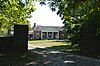 | March 13, 1997 (#97000163) | Gay Rd., junction with Donaldson Rd. at the Clark County line 38°06′24″N 84°06′56″W / 38.106667°N 84.115556°W / 38.106667; -84.115556 (Owen-Gay Farm) | Winchester | Extends into Clark County |
| 41 | Paris Cemetery Gatehouse |  | November 24, 1978 (#78001301) | US 68 Bus. 38°12′07″N 84°15′46″W / 38.201944°N 84.262778°W / 38.201944; -84.262778 (Paris Cemetery Gatehouse) | Paris | |
| 42 | Paris Courthouse Square Historic District |  | January 25, 1979 (#79000963) | Courthouse Sq. and environs 38°12′47″N 84°15′00″W / 38.213056°N 84.25°W / 38.213056; -84.25 (Paris Courthouse Square Historic District) | Paris | |
| 43 | Paris Railroad Depot |  | April 11, 1973 (#73000785) | Between 10th St. and Winchester Pike 38°12′23″N 84°15′03″W / 38.206389°N 84.250833°W / 38.206389; -84.250833 (Paris Railroad Depot) | Paris | |
| 44 | Pocket Rural Historic District |  | April 22, 2003 (#03000257) | Along See Rd., Kentucky Route 57, and Kentucky Route 1198 38°11′32″N 84°01′32″W / 38.192222°N 84.025556°W / 38.192222; -84.025556 (Pocket Rural Historic District) | Sharpsburg | |
| 45 | Thomas Rodgers House | Upload image | June 23, 1983 (#83002568) | U.S. Route 460 38°11′39″N 84°10′46″W / 38.194167°N 84.179444°W / 38.194167; -84.179444 (Thomas Rodgers House) | Paris | |
| 46 | Elias Rymill House |  | June 23, 1983 (#83002569) | Off Brentsville Rd. 38°16′07″N 84°20′28″W / 38.268611°N 84.341111°W / 38.268611; -84.341111 (Elias Rymill House) | Shawhan | |
| 47 | Sacred Home | Upload image | August 9, 1979 (#79000964) | West of Paris on Hume-Bedford Rd. 38°11′19″N 84°20′28″W / 38.188611°N 84.341111°W / 38.188611; -84.341111 (Sacred Home) | Paris | |
| 48 | Sandusky House | Upload image | June 23, 1983 (#83002570) | Off U.S. Route 68 38°17′00″N 84°07′18″W / 38.283333°N 84.121667°W / 38.283333; -84.121667 (Sandusky House) | Carlisle | |
| 49 | Laban Shipp House | Upload image | June 23, 1983 (#83002571) | Off Kentucky Route 1940 38°16′57″N 84°15′16″W / 38.2825°N 84.254444°W / 38.2825; -84.254444 (Laban Shipp House) | Shawhan | |
| 50 | Snow Hill | Upload image | November 7, 1997 (#97001341) | 4100 Little Rock-Jackstown Rd. 38°12′19″N 84°03′21″W / 38.205278°N 84.055833°W / 38.205278; -84.055833 (Snow Hill) | Little Rock | |
| 51 | Jacob Spears Distillery |  | June 23, 1983 (#83002573) | Kentucky Route 1876 38°16′05″N 84°18′26″W / 38.268056°N 84.307222°W / 38.268056; -84.307222 (Jacob Spears Distillery) | Shawhan | |
| 52 | Jacob Spears House |  | June 23, 1983 (#83002572) | Kentucky Route 1876 38°16′04″N 84°18′30″W / 38.267778°N 84.308333°W / 38.267778; -84.308333 (Jacob Spears House) | Shawhan | |
| 53 | Joseph L. Stephens House |  | June 23, 1983 (#83002574) | Kentucky Route 1940 38°18′35″N 84°14′29″W / 38.309722°N 84.241389°W / 38.309722; -84.241389 (Joseph L. Stephens House) | Millersburg | |
| 54 | Stoner Creek Rural Historic District | Upload image | May 2, 2001 (#01000449) | Along Winchester, Stoney Point, Spears Mill, and N. Middletown Rds. 38°09′53″N 84°11′12″W / 38.164722°N 84.186667°W / 38.164722; -84.186667 (Stoner Creek Rural Historic District) | Paris | |
| 55 | Sugar Grove |  | November 15, 1996 (#96001346) | 573 Clay-Kiser Rd. 38°14′32″N 84°20′09″W / 38.242222°N 84.335833°W / 38.242222; -84.335833 (Sugar Grove) | Paris | |
| 56 | John Tucker House | 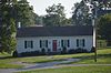 | March 30, 1995 (#95000302) | 405 McNease Rd. 38°16′32″N 84°19′36″W / 38.275417°N 84.326528°W / 38.275417; -84.326528 (John Tucker House) | Paris | |
| 57 | West Millersburg Rural Historic District | Upload image | May 24, 2007 (#06001197) | Millersburg-Ruddels Mills and Steele Ford Roads 38°18′18″N 84°10′32″W / 38.305000°N 84.175556°W / 38.305000; -84.175556 (West Millersburg Rural Historic District) | Millersburg | |
| 58 | Widow McDowell House | Upload image | June 23, 1983 (#83002576) | Kentucky Route 537 38°13′11″N 84°11′13″W / 38.219722°N 84.186944°W / 38.219722; -84.186944 (Widow McDowell House) | Paris | |
| 59 | Hubbard Williams House | Upload image | June 23, 1983 (#83002577) | Off Kentucky Routes 32/36 38°21′45″N 84°11′02″W / 38.3625°N 84.183889°W / 38.3625; -84.183889 (Hubbard Williams House) | Millersburg | |
| 60 | Woodlawn | Upload image | December 2, 1996 (#96001345) | Peacock Rd., approximately 2 miles north of Paris 38°14′41″N 84°15′23″W / 38.244722°N 84.256389°W / 38.244722; -84.256389 (Woodlawn) | Paris | |
| 61 | Capt. James Wright House and Cabin |  | October 8, 1976 (#76000846) | 1 mile southwest of Paris on U.S. Route 27 38°11′27″N 84°16′49″W / 38.190972°N 84.280278°W / 38.190972; -84.280278 (Capt. James Wright House and Cabin) | Paris |
See also
Wikimedia Commons has media related to National Register of Historic Places in Bourbon County, Kentucky.
- List of National Historic Landmarks in Kentucky
- National Register of Historic Places listings in Kentucky
References
- ^ The latitude and longitude information provided in this table was derived originally from the National Register Information System, which has been found to be fairly accurate for about 99% of listings. Some locations in this table may have been corrected to current GPS standards.
- ^ National Park Service, United States Department of the Interior, "National Register of Historic Places: Weekly List Actions", retrieved August 16, 2024.
- ^ Numbers represent an alphabetical ordering by significant words. Various colorings, defined here, differentiate National Historic Landmarks and historic districts from other NRHP buildings, structures, sites or objects.
- ^ The eight-digit number below each date is the number assigned to each location in the National Register Information System database, which can be viewed by clicking the number.
- v
- t
- e
- List of U.S. National Historic Landmarks by state:
- Alabama
- Alaska
- Arizona
- Arkansas
- California
- Colorado
- Connecticut
- Delaware
- Florida
- Georgia
- Hawaii
- Idaho
- Illinois
- Indiana
- Iowa
- Kansas
- Kentucky
- Louisiana
- Maine
- Maryland
- Massachusetts
- Michigan
- Minnesota
- Mississippi
- Missouri
- Montana
- Nebraska
- Nevada
- New Hampshire
- New Jersey
- New Mexico
- New York
- North Carolina
- North Dakota
- Ohio
- Oklahoma
- Oregon
- Pennsylvania
- Rhode Island
- South Carolina
- South Dakota
- Tennessee
- Texas
- Utah
- Vermont
- Virginia
- Washington
- West Virginia
- Wisconsin
- Wyoming
 National Register of Historic Places portal
 Category


Municipalities and communities of Bourbon County, Kentucky, United States | ||
|---|---|---|
County seat: Paris | ||
| Cities | 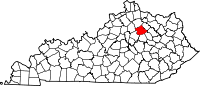 | |
| Unincorporated communities | ||
| ||


