National Register of Historic Places listings in Carroll County, Indiana

This is a list of the National Register of Historic Places listings in Carroll County, Indiana.
This is intended to be a complete list of the properties and districts on the National Register of Historic Places in Carroll County, Indiana, United States. Latitude and longitude coordinates are provided for many National Register properties and districts; these locations may be seen together in a map.[1]
There are 34 properties and districts listed on the National Register in the county. Another property was once listed but has been removed.
Properties and districts located in incorporated areas display the name of the municipality, while properties and districts in unincorporated areas display the name of their civil township. Properties and districts split between multiple jurisdictions display the names of all jurisdictions.
This National Park Service list is complete through NPS recent listings posted June 28, 2024.[2]
Map all coordinates using OpenStreetMap
Download coordinates as:
- KML
- GPX (all coordinates)
- GPX (primary coordinates)
- GPX (secondary coordinates)
Current listings
| [3] | Name on the Register[4] | Image | Date listed[5] | Location | City or town | Description |
|---|---|---|---|---|---|---|
| 1 | Adams Mill |  | November 23, 1984 (#84000278) | Off County Road 50E, northeast of Cutler 40°28′50″N 86°30′29″W / 40.480556°N 86.508056°W / 40.480556; -86.508056 (Adams Mill) | Democrat Township | |
| 2 | Adams Mill Covered Bridge | 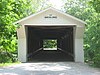 | January 11, 1996 (#95001537) | County Road 50E over Wildcat Creek, northeast of Cutler 40°29′01″N 86°30′42″W / 40.483611°N 86.511667°W / 40.483611; -86.511667 (Adams Mill Covered Bridge) | Democrat Township | |
| 3 | American House Hotel | Upload image | September 4, 2018 (#100002859) | 205 Michigan Rd. 40°28′52″N 86°23′42″W / 40.4812°N 86.3950°W / 40.4812; -86.3950 (American House Hotel) | Burlington | |
| 4 | Barnett-Seawright-Wilson House |  | September 17, 1980 (#80000054) | 203 E. Monroe St. 40°35′18″N 86°40′25″W / 40.588333°N 86.673611°W / 40.588333; -86.673611 (Barnett-Seawright-Wilson House) | Delphi | |
| 5 | Baum-Shaeffer Farm | 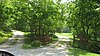 | August 28, 1998 (#98001102) | 6678 W200N, southeast of Delphi 40°34′28″N 86°39′11″W / 40.574444°N 86.653056°W / 40.574444; -86.653056 (Baum-Shaeffer Farm) | Deer Creek Township | |
| 6 | Burlington Township No. 9 School | Upload image | November 29, 2019 (#100004727) | 6013 Cty. Rd. East 600 South. 40°27′37″N 86°24′40″W / 40.4604°N 86.4110°W / 40.4604; -86.4110 (Burlington Township No. 9 School) | Burlington Township | |
| 7 | Burris House and Potawatomi Spring | 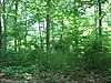 | September 15, 1977 (#77000018) | Towpath Rd. at Lockport 40°41′54″N 86°34′28″W / 40.698333°N 86.574444°W / 40.698333; -86.574444 (Burris House and Potawatomi Spring) | Adams Township | |
| 8 | Camden First Baptist Church | Upload image | February 22, 2023 (#100008659) | 225 East Main St. 40°36′31″N 86°32′16″W / 40.6087°N 86.5377°W / 40.6087; -86.5377 (Camden First Baptist Church) | Camden | |
| 9 | Camden Masonic Temple |  | December 23, 2003 (#03001313) | 213 W. Main St. 40°36′31″N 86°32′26″W / 40.608611°N 86.540556°W / 40.608611; -86.540556 (Camden Masonic Temple) | Camden | |
| 10 | Carroll County Courthouse |  | December 23, 2003 (#03001317) | 101 W. Main St. 40°35′10″N 86°40′29″W / 40.586111°N 86.674722°W / 40.586111; -86.674722 (Carroll County Courthouse) | Delphi | |
| 11 | Carroll County Infirmary | Upload image | December 3, 2018 (#100003177) | 6409 W100N 40°33′42″N 86°38′48″W / 40.5618°N 86.6466°W / 40.5618; -86.6466 (Carroll County Infirmary) | Deer Creek Township | |
| 12 | Carrollton Bridge |  | June 22, 2003 (#03000539) | Carrollton Rd. across the Wabash River, north of Delphi 40°38′54″N 86°39′24″W / 40.648333°N 86.656667°W / 40.648333; -86.656667 (Carrollton Bridge) | Adams, Deer Creek, and Tippecanoe Townships | |
| 13 | Deer Creek Valley Rural Historic District | 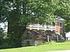 | December 19, 2002 (#02001557) | Southeastern corner of Sec. 21, most of Sec. 22, and areas north of Deer Creek, east of Delphi 40°35′35″N 86°37′49″W / 40.593056°N 86.630278°W / 40.593056; -86.630278 (Deer Creek Valley Rural Historic District) | Deer Creek Township | |
| 14 | Delphi City Hall |  | December 17, 1998 (#98001525) | 105-109 Washington St. 40°35′12″N 86°40′26″W / 40.586667°N 86.673889°W / 40.586667; -86.673889 (Delphi City Hall) | Delphi | |
| 15 | Delphi Courthouse Square Historic District | 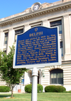 | March 31, 2010 (#10000120) | Roughly bounded by Monroe, the southern side of Main, and the western sides of Market and Indiana Sts. 40°35′11″N 86°40′29″W / 40.586358°N 86.674819°W / 40.586358; -86.674819 (Delphi Courthouse Square Historic District) | Delphi | |
| 16 | Delphi Lime Kilns |  | June 27, 2002 (#02000693) | North-northwest of Delphi 40°35′45″N 86°40′43″W / 40.595833°N 86.678611°W / 40.595833; -86.678611 (Delphi Lime Kilns) | Deer Creek Township | |
| 17 | Delphi Methodist Episcopal Church |  | September 14, 2015 (#15000592) | 118 N. Union St. 40°35′17″N 86°40′26″W / 40.588056°N 86.673889°W / 40.588056; -86.673889 (Delphi Methodist Episcopal Church) | Delphi | |
| 18 | District School No. 3 | 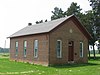 | March 31, 1988 (#88000374) | Southeastern corner of the junction of County Roads 750N and 100W, northeast of Rockfield 40°39′21″N 86°32′38″W / 40.655833°N 86.543889°W / 40.655833; -86.543889 (District School No. 3) | Rock Creek Township | |
| 19 | Foreman-Case House |  | May 24, 1990 (#90000811) | 312 E. Main St. 40°35′12″N 86°40′15″W / 40.586667°N 86.670833°W / 40.586667; -86.670833 (Foreman-Case House) | Delphi | |
| 20 | Franklin Street Stone Arch Bridge | Upload image | March 1, 2021 (#100006203) | Franklin St. over Old Canal 40°35′01″N 86°41′01″W / 40.5836°N 86.6835°W / 40.5836; -86.6835 (Franklin Street Stone Arch Bridge) | Delphi | |
| 21 | Lancaster Covered Bridge | 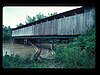 | March 2, 2021 (#100006206) | Cty. Rd. 500 W-500 S over Wildcat Cr. 40°28′04″N 86°37′02″W / 40.4677°N 86.6171°W / 40.4677; -86.6171 (Lancaster Covered Bridge) | Owasco vicinity | |
| 22 | Little Rock Creek Stone Arch Bridge | Upload image | March 2, 2021 (#100006207) | Cty. Rd. 1025 N-175 W over Little Rock Cr. Coordinates missing | Lockport vicinity | |
| 23 | Lock No. 33 Lock Keeper's House, and Wabash and Erie Canal Lock No. 33 | 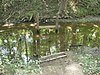 | June 24, 2002 (#02000684) | Along the Wabash and Erie Canal south of Bicycle Bridge Rd., southwest of Delphi[6] 40°34′52″N 86°41′00″W / 40.581111°N 86.683333°W / 40.581111; -86.683333 (Lock No. 33 Lock Keeper's House, and Wabash and Erie Canal Lock No. 33) | Deer Creek Township | |
| 24 | Niewerth Building |  | May 24, 1984 (#84001001) | 124 E. Main St. 40°35′10″N 86°40′22″W / 40.586111°N 86.672778°W / 40.586111; -86.672778 (Niewerth Building) | Delphi | |
| 25 | North Street Viaduct | Upload image | August 28, 2023 (#100009295) | North St. overpass at US 421/39/Washington St. 40°34′56″N 86°40′13″W / 40.5822°N 86.6703°W / 40.5822; -86.6703 (North Street Viaduct) | Delphi | |
| 26 | Fred and Minnie Raber Farm | 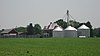 | September 16, 1992 (#92001169) | State Road 218 east of County Road 425W, west of Camden 40°36′21″N 86°36′11″W / 40.605833°N 86.603056°W / 40.605833; -86.603056 (Fred and Minnie Raber Farm) | Deer Creek Township | |
| 27 | South Delphi Historic District | Upload image | March 5, 2024 (#100010027) | Roughly bounded by the north boundary of Riley Park on the north, Prince William Road on the northeast, the alley south of Summit Street on the southeast, and Wabash Street and the west boundary of Riley Park on the south and southwest 40°34′54″N 86°40′11″W / 40.5818°N 86.6698°W / 40.5818; -86.6698 (South Delphi Historic District) | Delphi | |
| 28 | Sunset Point |  | June 24, 2002 (#02000685) | Confluence of Deer Creek and the Wabash River, southwest of Delphi[6] 40°34′20″N 86°41′18″W / 40.572111°N 86.688333°W / 40.572111; -86.688333 (Sunset Point) | Deer Creek Township | |
| 29 | Sycamore Row |  | June 24, 2002 (#100009297) | Old IN 29 from Deer Creek south approx. 1,300 feet (400 m) to IN 29 40°36′25″N 86°23′29″W / 40.6069°N 86.3913°W / 40.6069; -86.3913 (Sycamore Row) | Washington Township | |
| 30 | Andrew Thomas House |  | December 27, 1984 (#84000485) | W. Main St. 40°36′31″N 86°32′26″W / 40.608611°N 86.540556°W / 40.608611; -86.540556 (Andrew Thomas House) | Camden | |
| 31 | Wabash and Erie Canal Culvert No. 100 |  | March 20, 2002 (#02000194) | Towpath Rd. over Burnett's Creek, northeast of Lockport 40°42′11″N 86°34′02″W / 40.703056°N 86.567222°W / 40.703056; -86.567222 (Wabash and Erie Canal Culvert No. 100) | Adams Township | |
| 32 | Wagoner-Ayres House | Upload image | May 20, 2024 (#100010377) | 4565 East State Road 18 40°32′48″N 86°26′18″W / 40.5468°N 86.4384°W / 40.5468; -86.4384 (Wagoner-Ayres House) | Flora | |
| 33 | Washington Street Stone Arch Bridge | 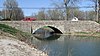 | March 1, 2021 (#100006209) | Washington St. over Old Canal 40°35′34″N 86°40′44″W / 40.5927°N 86.6789°W / 40.5927; -86.6789 (Washington Street Stone Arch Bridge) | Delphi | |
| 34 | Wilson Bridge |  | June 6, 2001 (#01000623) | 0.6 miles west of County Road 450W on County Road 300N over Deer Creek, east of Delphi 40°35′27″N 86°37′16″W / 40.590833°N 86.621111°W / 40.590833; -86.621111 (Wilson Bridge) | Deer Creek Township |
Former listing
| [3] | Name on the Register | Image | Date listed | Date removed | Location | City or town | Description |
|---|---|---|---|---|---|---|---|
| 1 | Pulaski County Bridge No. 31 |  | June 22, 2003 (#03000546) | October 1, 2014 | Spans the Wabash and Erie Canal, southwest of downtown Delphi[7] 40°34′59″N 86°41′00″W / 40.583056°N 86.683333°W / 40.583056; -86.683333 (Pulaski County Bridge No. 31) | Delphi | Formerly located on County Road 1175W near Medaryville;[4] moved to Delphi in 2006[8] |
See also
Wikimedia Commons has media related to National Register of Historic Places in Carroll County, Indiana.
- List of National Historic Landmarks in Indiana
- National Register of Historic Places listings in Indiana
- Listings in neighboring counties: Cass, Clinton, Howard, Tippecanoe, White
- List of Indiana state historical markers in Carroll County
References
- ^ The latitude and longitude information provided in this table was derived originally from the National Register Information System, which has been found to be fairly accurate for about 99% of listings. Some locations in this table may have been corrected to current GPS standards.
- ^ National Park Service, United States Department of the Interior, "National Register of Historic Places: Weekly List Actions", retrieved June 28, 2024.
- ^ a b Numbers represent an alphabetical ordering by significant words. Various colorings, defined here, differentiate National Historic Landmarks and historic districts from other NRHP buildings, structures, sites or objects.
- ^ a b "National Register Information System". National Register of Historic Places. National Park Service. March 13, 2009.
- ^ The eight-digit number below each date is the number assigned to each location in the National Register Information System database, which can be viewed by clicking the number.
- ^ a b Location derived from "Delphi, Indiana Trails Map Archived 2011-06-13 at the Wayback Machine". Wabash and Erie Canal Association, n.d. Accessed 2011-06-04. The NRIS lists the site as "Address Restricted".
- ^ Location derived from "Delphi, Indiana Trails Map Archived 2011-06-13 at the Wayback Machine". Wabash and Erie Canal Association, n.d. Accessed 2011-10-07.
- ^ Knapp, Carla (November 11, 2007). "Bridge offers unique look into history: Fully restored Stearns Truss bridge will be rededicated today". Pharos-Tribune. Logansport, Indiana. Retrieved 2011-10-07.
- v
- t
- e
- List of U.S. National Historic Landmarks by state:
- Alabama
- Alaska
- Arizona
- Arkansas
- California
- Colorado
- Connecticut
- Delaware
- Florida
- Georgia
- Hawaii
- Idaho
- Illinois
- Indiana
- Iowa
- Kansas
- Kentucky
- Louisiana
- Maine
- Maryland
- Massachusetts
- Michigan
- Minnesota
- Mississippi
- Missouri
- Montana
- Nebraska
- Nevada
- New Hampshire
- New Jersey
- New Mexico
- New York
- North Carolina
- North Dakota
- Ohio
- Oklahoma
- Oregon
- Pennsylvania
- Rhode Island
- South Carolina
- South Dakota
- Tennessee
- Texas
- Utah
- Vermont
- Virginia
- Washington
- West Virginia
- Wisconsin
- Wyoming
 National Register of Historic Places portal
 Category


