National Register of Historic Places listings in Ohio County, Indiana

This is a list of the National Register of Historic Places listings in Ohio County, Indiana.
This is intended to be a complete list of the properties and districts on National Register of Historic Places in Ohio County, Indiana, United States. Latitude and longitude coordinates are provided for many National Register properties and districts; these locations may be seen together in a map.[1]
There are 4 properties and districts listed on the National Register in the county.
Properties and districts located in incorporated areas display the name of the municipality, while properties and districts in unincorporated areas display the name of their civil township. Properties and districts split between multiple jurisdictions display the names of all jurisdictions.
This National Park Service list is complete through NPS recent listings posted June 7, 2024.[2]
Map all coordinates using OpenStreetMap
Download coordinates as:
- KML
- GPX (all coordinates)
- GPX (primary coordinates)
- GPX (secondary coordinates)
Current listings
| [3] | Name on the Register | Image | Date listed[4] | Location | City or town | Description |
|---|---|---|---|---|---|---|
| 1 | Clore Plow Works-J.W. Whitlock and Company | 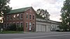 | September 17, 1999 (#99001152) | 212 S. Walnut St. 38°56′52″N 84°51′20″W / 38.947778°N 84.855556°W / 38.947778; -84.855556 (Clore Plow Works-J.W. Whitlock and Company) | Rising Sun | |
| 2 | Laughery Creek Bridge | 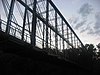 | September 29, 1976 (#76000018) | South of Aurora west of State Road 56 39°01′28″N 84°53′09″W / 39.024444°N 84.885833°W / 39.024444; -84.885833 (Laughery Creek Bridge) | Randolph Township | Extends into Dearborn County |
| 3 | Rising Sun Historic District | 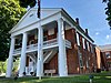 | October 12, 2006 (#06000935) | Roughly bounded by the Union and Soldier's Cemeteries, High St., Front St., and Maiden Ln. 38°56′54″N 84°51′09″W / 38.948333°N 84.852500°W / 38.948333; -84.852500 (Rising Sun Historic District) | Rising Sun | |
| 4 | Speakman-Miller-Kittle Farm | Upload image | December 11, 2023 (#100009592) | 10405 Old State Road 56 39°01′22″N 84°53′09″W / 39.0227°N 84.8859°W / 39.0227; -84.8859 (Speakman-Miller-Kittle Farm) | Rising Sun |
See also
Wikimedia Commons has media related to National Register of Historic Places in Ohio County, Indiana.
- List of National Historic Landmarks in Indiana
- National Register of Historic Places listings in Indiana
- Listings in neighboring counties: Boone (KY), Dearborn, Ripley, Switzerland
- List of Indiana state historical markers in Ohio County
References
- ^ The latitude and longitude information provided in this table was derived originally from the National Register Information System, which has been found to be fairly accurate for about 99% of listings. Some locations in this table may have been corrected to current GPS standards.
- ^ National Park Service, United States Department of the Interior, "National Register of Historic Places: Weekly List Actions", retrieved June 7, 2024.
- ^ Numbers represent an alphabetical ordering by significant words. Various colorings, defined here, differentiate National Historic Landmarks and historic districts from other NRHP buildings, structures, sites or objects.
- ^ The eight-digit number below each date is the number assigned to each location in the National Register Information System database, which can be viewed by clicking the number.
- v
- t
- e
- List of U.S. National Historic Landmarks by state:
- Alabama
- Alaska
- Arizona
- Arkansas
- California
- Colorado
- Connecticut
- Delaware
- Florida
- Georgia
- Hawaii
- Idaho
- Illinois
- Indiana
- Iowa
- Kansas
- Kentucky
- Louisiana
- Maine
- Maryland
- Massachusetts
- Michigan
- Minnesota
- Mississippi
- Missouri
- Montana
- Nebraska
- Nevada
- New Hampshire
- New Jersey
- New Mexico
- New York
- North Carolina
- North Dakota
- Ohio
- Oklahoma
- Oregon
- Pennsylvania
- Rhode Island
- South Carolina
- South Dakota
- Tennessee
- Texas
- Utah
- Vermont
- Virginia
- Washington
- West Virginia
- Wisconsin
- Wyoming
 National Register of Historic Places portal
 Category


