National Register of Historic Places listings in Holt County, Nebraska

This is a list of the National Register of Historic Places listings in Holt County, Nebraska. It is intended to be a complete list of the properties and districts on the National Register of Historic Places in Holt County, Nebraska, United States. The locations of National Register properties and districts for which the latitude and longitude coordinates are included below, may be seen in an online map.
There are 11 properties and districts listed on the National Register in the county.
This National Park Service list is complete through NPS recent listings posted September 13, 2024.[1]
Current listings
Map all coordinates using OpenStreetMap
Download coordinates as:
- KML
- GPX (all coordinates)
- GPX (primary coordinates)
- GPX (secondary coordinates)
| [2] | Name on the Register[3] | Image | Date listed[4] | Location | City or town | Description |
|---|---|---|---|---|---|---|
| 1 | W.J. Biglin House | Upload image | April 27, 2022 (#100007506) | 615 East Douglas St. 42°27′27″N 98°38′40″W / 42.4576°N 98.6444°W / 42.4576; -98.6444 (W.J. Biglin House) | O'Neill | |
| 2 | Eagle Creek Archeological Site | Upload image | October 1, 1974 (#74001119) | Address Restricted | O'Neill | |
| 3 | Golden Hotel |  | November 27, 1989 (#89002040) | 406 E. Douglas St. 42°27′29″N 98°38′49″W / 42.458056°N 98.646944°W / 42.458056; -98.646944 (Golden Hotel) | O'Neill | |
| 4 | Holt County Courthouse |  | July 5, 1990 (#90000974) | N. 4th St. between E. Clay and Benton Sts. 42°27′34″N 98°38′49″W / 42.459444°N 98.646944°W / 42.459444; -98.646944 (Holt County Courthouse) | O'Neill | |
| 5 | Old Nebraska State Bank Building | 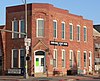 | October 1, 1974 (#74001120) | Douglas and 4th Sts. 42°27′26″N 98°38′49″W / 42.457222°N 98.646944°W / 42.457222; -98.646944 (Old Nebraska State Bank Building) | O'Neill | |
| 6 | O'Neill Carnegie Library | Upload image | July 13, 2018 (#100002665) | 601 E Douglas St. 42°27′28″N 98°38′40″W / 42.4577°N 98.6444°W / 42.4577; -98.6444 (O'Neill Carnegie Library) | O'Neill | |
| 7 | Redbird I Site | Upload image | November 21, 1974 (#74001121) | Hilltop in the east central portion of Section 11, Township 32 North, Range 10 West[5] 42°46′00″N 98°26′40″W / 42.766667°N 98.444444°W / 42.766667; -98.444444 (Redbird I Site) | Redbird | |
| 8 | Rouse Ranch |  | September 4, 2013 (#13000674) | 88780 495th Ave. 42°41′41″N 98°35′57″W / 42.694809°N 98.599123°W / 42.694809; -98.599123 (Rouse Ranch) | O'Neill vicinity | |
| 9 | St. Patrick’s Catholic Church | Upload image | July 1, 2020 (#100005337) | 301 East Benton St. 42°27′36″N 98°38′54″W / 42.4601°N 98.6482°W / 42.4601; -98.6482 (St. Patrick’s Catholic Church) | O'Neill | |
| 10 | Brantly Sturdevant House |  | March 25, 1999 (#99000387) | 308 S. Main St. 42°31′44″N 98°58′43″W / 42.5288°N 98.9786°W / 42.5288; -98.9786 (Brantly Sturdevant House) | Atkinson | |
| 11 | US Post Office-O'Neill | 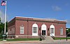 | May 11, 1992 (#92000479) | 204 N. 4th St. 42°27′33″N 98°38′53″W / 42.459133°N 98.648182°W / 42.459133; -98.648182 (US Post Office-O'Neill) | O'Neill | One of 12 Nebraska post offices featuring a Section of Fine Arts mural, "Baling Hay in Holt County in the Early Days" (1938) by Eugene Trentham.[6] |
See also
- List of National Historic Landmarks in Nebraska
- National Register of Historic Places listings in Nebraska
References
Wikimedia Commons has media related to National Register of Historic Places in Holt County, Nebraska.
- ^ National Park Service, United States Department of the Interior, "National Register of Historic Places: Weekly List Actions", retrieved September 13, 2024.
- ^ Numbers represent an alphabetical ordering by significant words. Various colorings, defined here, differentiate National Historic Landmarks and historic districts from other NRHP buildings, structures, sites or objects.
- ^ "National Register Information System". National Register of Historic Places. National Park Service. March 13, 2009.
- ^ The eight-digit number below each date is the number assigned to each location in the National Register Information System database, which can be viewed by clicking the number.
- ^ Howard, James H. "Known Village Sites of the Ponca". Plains Anthropologist 15.48 (1970): 109-134: 120-121.
- ^ Ahlgren, Carol (August 1991). "National Register of Historic Places Multiple Property Documentation Form: Nebraska Post Offices Which Contain Section Artwork (1938-1942)" (PDF). Archived from the original on May 13, 2013. Retrieved 2013-01-28.
{{cite journal}}: Cite journal requires|journal=(help)CS1 maint: unfit URL (link)
- v
- t
- e

- Adams
- Antelope
- Arthur
- Banner
- Blaine
- Boone
- Box Butte
- Boyd
- Brown
- Buffalo
- Burt
- Butler
- Cass
- Cedar
- Chase
- Cherry
- Cheyenne
- Clay
- Colfax
- Cuming
- Custer
- Dakota
- Dawes
- Dawson
- Deuel
- Dixon
- Dodge
- Douglas
- Dundy
- Fillmore
- Franklin
- Frontier
- Furnas
- Gage
- Garden
- Garfield
- Gosper
- Grant
- Greeley
- Hall
- Hamilton
- Harlan
- Hayes
- Hitchcock
- Holt
- Hooker
- Howard
- Jefferson
- Johnson
- Kearney
- Keith
- Keya Paha
- Kimball
- Knox
- Lancaster
- Lincoln
- Logan
- Loup
- Madison
- McPherson
- Merrick
- Morrill
- Nance
- Nemaha
- Nuckolls
- Otoe
- Pawnee
- Perkins
- Phelps
- Pierce
- Platte
- Polk
- Red Willow
- Richardson
- Rock
- Saline
- Sarpy
- Saunders
- Scotts Bluff
- Seward
- Sheridan
- Sherman
- Sioux
- Stanton
- Thayer
- Thomas
- Thurston
- Valley
- Washington
- Wayne
- Webster
- Wheeler
- York
- Bridges
- Historic districts
- Houses
- National Historic Landmarks
- Properties of religious function
- Railway stations
 Category
 List
List National Register of Historic Places Portal


Municipalities and communities of Holt County, Nebraska, United States | ||
|---|---|---|
County seat: O'Neill | ||
| Cities |  | |
| Villages | ||
| Townships |
| |
| Unincorporated communities | ||
| ||


