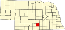
National Register of Historic Places listings in Kearney County, Nebraska
This is a list of the National Register of Historic Places listings in Kearney County, Nebraska. It is intended to be a complete list of the properties and districts on the National Register of Historic Places in Kearney County, Nebraska, United States. The locations of National Register properties and districts for which the latitude and longitude coordinates are included below, may be seen in an online map.
There are 8 properties and districts listed on the National Register in the county.
This National Park Service list is complete through NPS recent listings posted September 5, 2024.[1]
Current listings
Map all coordinates using OpenStreetMap
Download coordinates as:
- KML
- GPX (all coordinates)
- GPX (primary coordinates)
- GPX (secondary coordinates)
| [2] | Name on the Register[3] | Image | Date listed[4] | Location | City or town | Description |
|---|---|---|---|---|---|---|
| 1 | Bethphage Mission | 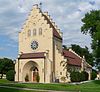 | April 24, 2013 (#13000199) | 1044 23rd Road 40°29′13″N 99°07′16″W / 40.486829°N 99.121231°W / 40.486829; -99.121231 (Bethphage Mission) | Axtell vicinity | |
| 2 | Eddie Eugene and Harriet Cotton Carpenter Farmstead |  | February 25, 1993 (#93000059) | Approximately 0.5 miles west of Lowell 40°38′54″N 98°51′31″W / 40.648333°N 98.858611°W / 40.648333; -98.858611 (Eddie Eugene and Harriet Cotton Carpenter Farmstead) | Lowell | |
| 3 | Dobytown |  | December 16, 1974 (#74001125) | Southwest of Kearney[5] 40°38′30″N 99°02′51″W / 40.641667°N 99.047500°W / 40.641667; -99.047500 (Dobytown) | Kearney | |
| 4 | Fort Kearney |  | July 2, 1971 (#71000485) | 2 miles west of Newark on Nebraska Highway 10 40°38′36″N 99°00′25″W / 40.643333°N 99.006944°W / 40.643333; -99.006944 (Fort Kearney) | Newark | |
| 5 | Kearney County Courthouse |  | January 10, 1990 (#89002234) | 5th St. between Colorado and Minden Aves. 40°29′56″N 98°56′53″W / 40.498889°N 98.948056°W / 40.498889; -98.948056 (Kearney County Courthouse) | Minden | |
| 6 | Salem Swedish Methodist Episcopal Church | 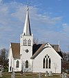 | July 29, 1982 (#82003192) | Southwest of Axtell 40°27′11″N 99°10′42″W / 40.453056°N 99.178333°W / 40.453056; -99.178333 (Salem Swedish Methodist Episcopal Church) | Axtell | |
| 7 | W. T. Thorne Building | 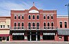 | September 12, 1985 (#85002139) | 5th St. 40°29′59″N 98°56′54″W / 40.499722°N 98.948333°W / 40.499722; -98.948333 (W. T. Thorne Building) | Minden | |
| 8 | US Post Office-Minden |  | May 11, 1992 (#92000471) | 410 N. Minden St. 40°29′55″N 98°56′50″W / 40.498732°N 98.947358°W / 40.498732; -98.947358 (US Post Office-Minden) | Minden | One of 12 Nebraska post offices featuring a Section of Fine Arts mural, "1848-Fort Kearney, Protectorate on the Overland Trail-1871" (1939) by William E. L. Bunn.[6] |
See also
- List of National Historic Landmarks in Nebraska
- National Register of Historic Places listings in Nebraska
References
- ^ National Park Service, United States Department of the Interior, "National Register of Historic Places: Weekly List Actions", retrieved September 5, 2024.
- ^ Numbers represent an alphabetical ordering by significant words. Various colorings, defined here, differentiate National Historic Landmarks and historic districts from other NRHP buildings, structures, sites or objects.
- ^ "National Register Information System". National Register of Historic Places. National Park Service. March 13, 2009.
- ^ The eight-digit number below each date is the number assigned to each location in the National Register Information System database, which can be viewed by clicking the number.
- ^ Location derived from its GNIS feature record; the NRIS lists it as "Address Restricted"
- ^ Ahlgren, Carol (August 1991). "National Register of Historic Places Multiple Property Documentation Form: Nebraska Post Offices Which Contain Section Artwork (1938-1942)" (PDF). Archived from the original on May 13, 2013. Retrieved 2013-01-28.
{{cite journal}}: Cite journal requires|journal=(help)CS1 maint: unfit URL (link)
External links
Wikimedia Commons has media related to National Register of Historic Places in Kearney County, Nebraska.
- v
- t
- e

See also: National Register of Historic Places listings in Kearney County, Nebraska and List of National Historic Landmarks in Nebraska
| ||
|---|---|---|
| Topics |  | |
| Lists by county |
| |
| Other lists |
| |
| ||


Municipalities and communities of Kearney County, Nebraska, United States | ||
|---|---|---|
County seat: Minden | ||
| City |  | |
| Villages | ||
| Townships | ||
| Unincorporated communities | ||
| Ghost town | ||
| ||


