National Register of Historic Places listings in Logan County, Oklahoma
This is a list of the National Register of Historic Places listings in Logan County, Oklahoma.
This is intended to be a complete list of the properties and districts on the National Register of Historic Places in Logan County, Oklahoma, United States. The locations of National Register properties and districts for which the latitude and longitude coordinates are included below, may be seen in a map.[1]
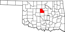
There are 16 properties and districts listed on the National Register in the county, including 1 National Historic Landmark.
This National Park Service list is complete through NPS recent listings posted July 26, 2024.[2]
Map all coordinates using OpenStreetMap
Download coordinates as:
- KML
- GPX (all coordinates)
- GPX (primary coordinates)
- GPX (secondary coordinates)
Current listings
| [3] | Name on the Register[4] | Image | Date listed[5] | Location | City or town | Description |
|---|---|---|---|---|---|---|
| 1 | Benedictine Heights Hospital |  | December 4, 2017 (#100001869) | 2000 W. Warner St. 35°52′51″N 97°26′57″W / 35.880961°N 97.449195°W / 35.880961; -97.449195 (Benedictine Heights Hospital) | Guthrie | |
| 2 | Carnegie Library | 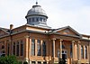 | June 21, 1971 (#71000666) | Oklahoma Ave. and Ash St. 35°52′48″N 97°25′05″W / 35.88°N 97.418056°W / 35.88; -97.418056 (Carnegie Library) | Guthrie | |
| 3 | Co-Operative Publishing Company Building |  | March 7, 1973 (#73001564) | Harrison Ave. and 2nd St. 35°52′36″N 97°25′40″W / 35.8768°N 97.4279°W / 35.8768; -97.4279 (Co-Operative Publishing Company Building) | Guthrie | |
| 4 | Angie Debo House |  | April 4, 1996 (#96000379) | 200 Oklahoma Ave. 36°09′18″N 97°37′23″W / 36.155°N 97.623056°W / 36.155; -97.623056 (Angie Debo House) | Marshall | |
| 5 | Excelsior Library |  | March 15, 2016 (#16000087) | 323 S. 2nd St. 35°52′31″N 97°25′39″W / 35.875200°N 97.427581°W / 35.875200; -97.427581 (Excelsior Library) | Guthrie | |
| 6 | Guthrie Armory |  | September 8, 1994 (#94001083) | 720 E. Logan 35°53′01″N 97°25′00″W / 35.883611°N 97.416667°W / 35.883611; -97.416667 (Guthrie Armory) | Guthrie | |
| 7 | Guthrie Historic District |  | June 13, 1974 (#74001664) | Roughly bounded by Oklahoma Ave., S. Broad St., and Harrison Ave. 35°52′41″N 97°25′31″W / 35.8781°N 97.4254°W / 35.8781; -97.4254 (Guthrie Historic District) | Guthrie | |
| 8 | Langston University Cottage Row Historic District | Upload image | January 7, 1999 (#98001593) | Southwestern corner of the Langston University campus 35°56′36″N 97°15′47″W / 35.943333°N 97.263056°W / 35.943333; -97.263056 (Langston University Cottage Row Historic District) | Langston | |
| 9 | Logan County Courthouse | 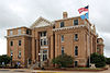 | October 26, 1984 (#84003141) | 301 E. Harrison St. 35°52′36″N 97°25′19″W / 35.876667°N 97.421944°W / 35.876667; -97.421944 (Logan County Courthouse) | Guthrie | |
| 10 | Methodist Church of Marshall |  | September 28, 1984 (#84003143) | Off State Highway 74 36°09′17″N 97°37′22″W / 36.154722°N 97.622778°W / 36.154722; -97.622778 (Methodist Church of Marshall) | Marshall | |
| 11 | Morris House | Upload image | September 8, 1994 (#94001082) | 221 Tolson Boulevard 35°56′38″N 97°15′17″W / 35.943889°N 97.254722°W / 35.943889; -97.254722 (Morris House) | Langston | |
| 12 | Mulhall United Methodist Church | 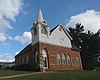 | June 22, 1984 (#84003145) | Bryant and Craig Sts. 36°03′48″N 97°24′13″W / 36.063333°N 97.403611°W / 36.063333; -97.403611 (Mulhall United Methodist Church) | Mulhall | |
| 13 | Oklahoma State Bank Building | Upload image | June 22, 1984 (#84003146) | Baty and Main Sts. 36°03′54″N 97°24′26″W / 36.065°N 97.407222°W / 36.065; -97.407222 (Oklahoma State Bank Building) | Mulhall | |
| 14 | Ozark Trails-Indian Meridian Obelisk |  | June 12, 2017 (#100001074) | Jct. of Logan & E. Washington Aves. 35°56′32″N 97°14′49″W / 35.942110°N 97.247060°W / 35.942110; -97.247060 (Ozark Trails-Indian Meridian Obelisk) | Langston | |
| 15 | St. Joseph Convent and Academy | Upload image | December 19, 1979 (#79002000) | Due south of current-day Oklahoma SH-33 35°52′17″N 97°27′39″W / 35.871361°N 97.460972°W / 35.871361; -97.460972 (St. Joseph Convent and Academy) | Guthrie | Demolished in 1995[6] |
| 16 | Scottish Rite Temple | 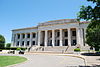 | April 9, 1987 (#87000503) | 900 E. Oklahoma 35°52′41″N 97°24′48″W / 35.878056°N 97.413333°W / 35.878056; -97.413333 (Scottish Rite Temple) | Guthrie |
See also
Wikimedia Commons has media related to National Register of Historic Places in Logan County, Oklahoma.
- List of National Historic Landmarks in Oklahoma
- National Register of Historic Places listings in Oklahoma
References
- ^ The latitude and longitude information provided in this table was derived originally from the National Register Information System, which has been found to be fairly accurate for about 99% of listings. Some locations in this table may have been corrected to current GPS standards.
- ^ National Park Service, United States Department of the Interior, "National Register of Historic Places: Weekly List Actions", retrieved July 26, 2024.
- ^ Numbers represent an alphabetical ordering by significant words. Various colorings, defined here, differentiate National Historic Landmarks and historic districts from other NRHP buildings, structures, sites or objects.
- ^ "National Register Information System". National Register of Historic Places. National Park Service. March 13, 2009.
- ^ The eight-digit number below each date is the number assigned to each location in the National Register Information System database, which can be viewed by clicking the number.
- ^ Oklahoma Historical Society, State Historic Preservation Office; Oklahoma State University, Department of Geography. "Oklahoma National Register". nr2_shpo.okstate.edu. Oklahoma Historical Society. Archived from the original on July 9, 2024. Retrieved July 10, 2024.
- v
- t
- e
- Benedictine Heights Hospital
- Carnegie Library
- Co-operative Publishing Company Building
- Excelsior Library
- Guthrie Armory
- Guthrie Historic District
- Logan County Courthouse
- Scottish Rite Temple
- St. Joseph Convent and Academy

- Langston University Cottage Row Historic District
- Morris House
- Ozark Trails-Indian Meridian Obelisk
- Angie Debo House
- Methodist Church of Marshall
- Mulhall United Methodist Church
- Oklahoma State Bank Building
See also: National Register of Historic Places listings in Logan County, Oklahoma and List of National Historic Landmarks in Oklahoma
| |
|---|---|
| Topics | |
| Lists by state |
|
| Lists by insular areas | |
| Lists by associated state | |
| Other areas | |
| Related | |
| |


