National Register of Historic Places listings in Osage County, Oklahoma

This is a list of the National Register of Historic Places listings in Osage County, Oklahoma.
This is intended to be a complete list of the properties and districts on the National Register of Historic Places in Osage County, Oklahoma, United States. The locations of National Register properties and districts for which the latitude and longitude coordinates are included below, may be seen in a map.[1]
There are 23 properties and districts listed on the National Register in the county.
This National Park Service list is complete through NPS recent listings posted August 16, 2024.[2]
Map all coordinates using OpenStreetMap
Download coordinates as:
- KML
- GPX (all coordinates)
- GPX (primary coordinates)
- GPX (secondary coordinates)
Current listings
| [3] | Name on the Register[4] | Image | Date listed[5] | Location | City or town | Description |
|---|---|---|---|---|---|---|
| 1 | Bank of Bigheart |  | November 23, 1984 (#84000311) | 308 W. Main St. 36°33′43″N 96°09′42″W / 36.56197°N 96.16167°W / 36.56197; -96.16167 (Bank of Bigheart) | Barnsdall | |
| 2 | Bank of Burbank | Upload image | November 23, 1984 (#84000314) | McCorkle and 1st Sts. 36°41′53″N 96°43′36″W / 36.69808°N 96.72672°W / 36.69808; -96.72672 (Bank of Burbank) | Burbank | Single-story small bank building, built in 1910, which served as a bank for 38 years and as the post office for 30 more. |
| 3 | Bank of Hominy | 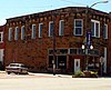 | November 23, 1984 (#84000316) | 102 W. Main St. 36°24′55″N 96°23′40″W / 36.41536°N 96.39435°W / 36.41536; -96.39435 (Bank of Hominy) | Hominy | Two-story commercial building built in 1906. |
| 4 | Barnsdall Main Street Well Site |  | October 1, 1997 (#97001153) | West of the junction of State Highway 11 and Main St. 36°33′42″N 96°09′57″W / 36.561667°N 96.165833°W / 36.561667; -96.165833 (Barnsdall Main Street Well Site) | Barnsdall | |
| 5 | Blacksmith's House |  | May 7, 1979 (#79002014) | 210 W. Main St. 36°39′48″N 96°20′32″W / 36.663333°N 96.342222°W / 36.663333; -96.342222 (Blacksmith's House) | Pawhuska | |
| 6 | Chapman-Barnard Ranch Headquarters | 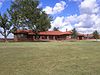 | March 2, 2001 (#01000208) | 1511 County Route 4201 36°50′47″N 96°25′22″W / 36.846389°N 96.422778°W / 36.846389; -96.422778 (Chapman-Barnard Ranch Headquarters) | Pawhuska | |
| 7 | Chief Ne-Kah-Wah-She-Tun-Kah Grave and Statue |  | May 22, 1979 (#79002012) | Off State Highway 18 36°33′52″N 96°42′37″W / 36.564444°N 96.710278°W / 36.564444; -96.710278 (Chief Ne-Kah-Wah-She-Tun-Kah Grave and Statue) | Fairfax | |
| 8 | City Hall | 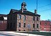 | January 1, 1976 (#76001574) | 118 W. Main St. 36°39′47″N 96°20′27″W / 36.663056°N 96.340833°W / 36.663056; -96.340833 (City Hall) | Pawhuska | |
| 9 | Fred and Adeline Drummond House |  | April 16, 1981 (#81000466) | 305 N. Price Ave. 36°25′04″N 96°23′39″W / 36.417778°N 96.394167°W / 36.417778; -96.394167 (Fred and Adeline Drummond House) | Hominy | |
| 10 | First National Bank and Masonic Lodge | Upload image | June 22, 1984 (#84003393) | 301 N. Main St. 36°34′15″N 96°42′16″W / 36.570833°N 96.704444°W / 36.570833; -96.704444 (First National Bank and Masonic Lodge) | Fairfax | |
| 11 | Hominy Armory |  | May 20, 1994 (#94000482) | 201 N. Regan St. 36°25′01″N 96°23′43″W / 36.416944°N 96.395278°W / 36.416944; -96.395278 (Hominy Armory) | Hominy | |
| 12 | Hominy Osage Round House | 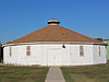 | May 16, 1979 (#79002013) | Round House Sq. in Indian Village 36°24′41″N 96°23′07″W / 36.411389°N 96.385278°W / 36.411389; -96.385278 (Hominy Osage Round House) | Hominy | |
| 13 | Hominy School | 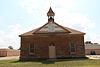 | August 12, 1988 (#88001183) | 200 block of S. Pettit St. 36°24′50″N 96°23′26″W / 36.413889°N 96.390556°W / 36.413889; -96.390556 (Hominy School) | Hominy | |
| 14 | Immaculate Conception Church | 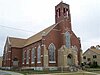 | May 21, 1979 (#79002015) | 1314 Lynn Ave. 36°40′17″N 96°19′53″W / 36.671321°N 96.331364°W / 36.671321; -96.331364 (Immaculate Conception Church) | Pawhuska | |
| 15 | Lincoln Colored School | 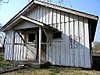 | December 5, 2003 (#03001238) | 171 NE. Walnut 36°34′33″N 96°42′07″W / 36.575833°N 96.701944°W / 36.575833; -96.701944 (Lincoln Colored School) | Fairfax | |
| 16 | Marland Filling Station | 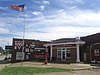 | September 14, 2002 (#02000970) | 102 S. Wood 36°24′55″N 96°23′31″W / 36.415278°N 96.391944°W / 36.415278; -96.391944 (Marland Filling Station) | Hominy | |
| 17 | Osage Agency | 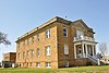 | May 17, 1974 (#74001666) | Agency Hill 36°39′57″N 96°20′26″W / 36.6658°N 96.3406°W / 36.6658; -96.3406 (Osage Agency) | Pawhuska | |
| 18 | Osage Bank of Fairfax | Upload image | November 23, 1984 (#84000315) | 250 N. Main St. 36°34′24″N 96°42′15″W / 36.57328°N 96.70409°W / 36.57328; -96.70409 (Osage Bank of Fairfax) | Fairfax | |
| 19 | Osage County Courthouse | 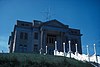 | August 23, 1984 (#84003395) | 600 Grandview Avenue 36°39′52″N 96°20′28″W / 36.664444°N 96.341111°W / 36.664444; -96.341111 (Osage County Courthouse) | Pawhuska | |
| 20 | Pawhuska Armory |  | May 20, 1994 (#94000485) | 823 E. 8th St. 36°39′56″N 96°19′40″W / 36.665556°N 96.327778°W / 36.665556; -96.327778 (Pawhuska Armory) | Pawhuska | |
| 21 | Pawhuska Downtown Historic District |  | November 26, 1986 (#86002355) | Roughly bounded by Grand View Ave., E. 8th St., Leahy Ave., and E. 5th St. 36°39′51″N 96°20′25″W / 36.664167°N 96.340278°W / 36.664167; -96.340278 (Pawhuska Downtown Historic District) | Pawhuska | |
| 22 | Wolverine Oil Company Drayage Barn | Upload image | March 4, 1998 (#97001152) | State Highway 11, 3.5 miles north of Avant 36°32′36″N 96°04′18″W / 36.543333°N 96.071667°W / 36.543333; -96.071667 (Wolverine Oil Company Drayage Barn) | Avant | |
| 23 | Woolaroc Ranch Historic District |  | December 5, 2008 (#08001151) | 8 miles east of the junction of State Highways 11 and 123 36°39′47″N 96°06′36″W / 36.663°N 96.110°W / 36.663; -96.110 (Woolaroc Ranch Historic District) | Barnsdall |
See also
Wikimedia Commons has media related to National Register of Historic Places in Osage County, Oklahoma.
- List of National Historic Landmarks in Oklahoma
- National Register of Historic Places listings in Oklahoma
References
- ^ The latitude and longitude information provided in this table was derived originally from the National Register Information System, which has been found to be fairly accurate for about 99% of listings. Some locations in this table may have been corrected to current GPS standards.
- ^ National Park Service, United States Department of the Interior, "National Register of Historic Places: Weekly List Actions", retrieved August 16, 2024.
- ^ Numbers represent an alphabetical ordering by significant words. Various colorings, defined here, differentiate National Historic Landmarks and historic districts from other NRHP buildings, structures, sites or objects.
- ^ "National Register Information System". National Register of Historic Places. National Park Service. March 13, 2009.
- ^ The eight-digit number below each date is the number assigned to each location in the National Register Information System database, which can be viewed by clicking the number.
- v
- t
- e
- Wolverine Oil Company Drayage Barn

- Chief Ne-Kah-Wah-She-Tun-Kah Grave and Statue
- First National Bank and Masonic Lodge
- Lincoln Colored School
- Osage Bank of Fairfax
- Blacksmith's House
- Chapman-Barnard Ranch Headquarters
- City Hall
- Immaculate Conception Church
- Osage Agency
- Osage County Courthouse
- Pawhuska Armory
- Pawhuska Downtown Historic District
See also: National Register of Historic Places listings in Osage County, Oklahoma and List of National Historic Landmarks in Oklahoma
| |
|---|---|
| Topics | |
| Lists by state |
|
| Lists by insular areas | |
| Lists by associated state | |
| Other areas | |
| Related | |
| |


Municipalities and communities of Osage County, Oklahoma, United States | ||
|---|---|---|
County seat: Pawhuska | ||
| Cities |  | |
| Towns | ||
| CDPs | ||
| Other communities | ||
| Indian reservation | ||
| Footnotes | ‡This populated place also has portions in an adjacent county or counties | |
| ||


