National Register of Historic Places listings in Phillips County, Kansas

This is a list of the National Register of Historic Places listings in Phillips County, Kansas.
This is intended to be a complete list of the properties and districts on the National Register of Historic Places in Phillips County, Kansas, United States. The locations of National Register properties and districts for which the latitude and longitude coordinates are included below, may be seen in a map.[1]
There are 9 properties and districts listed on the National Register in the county.
This National Park Service list is complete through NPS recent listings posted September 5, 2024.[2]
Map all coordinates using OpenStreetMap
Download coordinates as:
- KML
- GPX (all coordinates)
- GPX (primary coordinates)
- GPX (secondary coordinates)
Current listings
| [3] | Name on the Register[4] | Image | Date listed[5] | Location | City or town | Description |
|---|---|---|---|---|---|---|
| 1 | Agra Consolidated School |  | November 15, 2005 (#05001246) | 941 Kansas Ave. 39°45′41″N 99°06′52″W / 39.761286°N 99.114555°W / 39.761286; -99.114555 (Agra Consolidated School) | Agra | Now Thunder Ridge Middle School[6] |
| 2 | Agra Lake and Park |  | June 26, 2008 (#08000616) | ¼ mile north of U.S. Route 36 on the west edge of Agra. 39°45′41″N 99°07′34″W / 39.761389°N 99.126111°W / 39.761389; -99.126111 (Agra Lake and Park) | Agra | |
| 3 | Battle Creek King Post Truss Bridge |  | May 9, 2003 (#03000362) | W. Eagle Rd., 3.0 miles east of its junction with Washington Rd. 39°56′39″N 99°28′47″W / 39.944072°N 99.479587°W / 39.944072; -99.479587 (Battle Creek King Post Truss Bridge) | Long Island | |
| 4 | Hoff School District No. 42 |  | January 18, 2011 (#10001140) | Near intersection of E. Union Rd. and E. 1300 Rd. 39°42′50″N 99°05′05″W / 39.713757°N 99.084618°W / 39.713757; -99.084618 (Hoff School District No. 42) | Kirwin | Public Schools of Kansas MPS |
| 5 | Jack Creek Kingpost |  | January 4, 1990 (#89002188) | Eagle Rd east of West 600 Rd 39°56′39″N 99°26′20″W / 39.944107°N 99.438804°W / 39.944107; -99.438804 (Jack Creek Kingpost) | Long Island | |
| 6 | Kirwin City Hall | 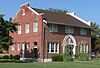 | June 7, 2006 (#06000471) | 1st and Main Sts. 39°40′23″N 99°07′20″W / 39.673056°N 99.122222°W / 39.673056; -99.122222 (Kirwin City Hall) | Kirwin | |
| 7 | Long Island School | 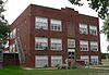 | June 9, 2005 (#05000551) | Washington Street 39°56′47″N 99°32′04″W / 39.946472°N 99.534532°W / 39.946472; -99.534532 (Long Island School) | Long Island | |
| 8 | Phillipsburg Community Building |  | October 20, 2010 (#10000845) | 425 F St. 39°45′26″N 99°19′22″W / 39.757301°N 99.322691°W / 39.757301; -99.322691 (Phillipsburg Community Building) | Phillipsburg | New Deal-Era Resources of Kansas MPS |
| 9 | Pleasant Ridge Church |  | November 5, 2005 (#05001204) | 381 E. Buffalo Rd. 39°59′15″N 99°15′27″W / 39.987427°N 99.257433°W / 39.987427; -99.257433 (Pleasant Ridge Church) | Phillipsburg |
See also
Wikimedia Commons has media related to National Register of Historic Places in Phillips County, Kansas.
- List of National Historic Landmarks in Kansas
- National Register of Historic Places listings in Kansas
References
- ^ The latitude and longitude information provided in this table was derived originally from the National Register Information System, which has been found to be fairly accurate for about 99% of listings. Some locations in this table may have been corrected to current GPS standards.
- ^ National Park Service, United States Department of the Interior, "National Register of Historic Places: Weekly List Actions", retrieved September 5, 2024.
- ^ Numbers represent an alphabetical ordering by significant words. Various colorings, defined here, differentiate National Historic Landmarks and historic districts from other NRHP buildings, structures, sites or objects.
- ^ "National Register Information System". National Register of Historic Places. National Park Service. March 13, 2009.
- ^ The eight-digit number below each date is the number assigned to each location in the National Register Information System database, which can be viewed by clicking the number.
- ^ "Thunder Ridge Schools." Thunder Ridge Schools home. Retrieved 2014-09-07.
- v
- t
- e

- Allen
- Anderson
- Atchison
- Barber
- Barton
- Bourbon
- Brown
- Butler
- Chase
- Chautauqua
- Cherokee
- Cheyenne
- Clark
- Clay
- Cloud
- Coffey
- Comanche
- Cowley
- Crawford
- Decatur
- Dickinson
- Doniphan
- Douglas
- Edwards
- Elk
- Ellis
- Ellsworth
- Finney
- Ford
- Franklin
- Geary
- Gove
- Graham
- Grant
- Gray
- Greeley
- Greenwood
- Hamilton
- Harper
- Harvey
- Haskell
- Hodgeman
- Jackson
- Jefferson
- Jewell
- Johnson
- Kearny
- Kingman
- Kiowa
- Labette
- Lane
- Leavenworth
- Lincoln
- Linn
- Logan
- Lyon
- Marion
- McPherson
- Meade
- Miami
- Mitchell
- Montgomery
- Morris
- Morton
- Nemaha
- Neosho
- Ness
- Norton
- Osage
- Osborne
- Ottawa
- Pawnee
- Phillips
- Pottawatomie
- Pratt
- Rawlins
- Reno
- Republic
- Rice
- Riley
- Rooks
- Rush
- Russell
- Saline
- Scott
- Sedgwick
- Seward
- Shawnee
- Sheridan
- Sherman
- Smith
- Stafford
- Stanton
- Stevens
- Sumner
- Thomas
- Trego
- Wabaunsee
- Wallace
- Washington
- Wichita
- Wilson
- Woodson
- Wyandotte
- Archaeological sites
- National Historic Landmarks
 Category
 NRHP portal


Municipalities and communities of Phillips County, Kansas, United States | ||
|---|---|---|
County seat: Phillipsburg | ||
| Cities |  | |
| CDPs | ||
| Unincorporated community | ||
| Ghost towns | ||
| Townships |
| |
| ||


