National Register of Historic Places listings in Wabaunsee County, Kansas

This is a list of the National Register of Historic Places listings in Wabaunsee County, Kansas.
This is intended to be a complete list of the properties and districts on the National Register of Historic Places in Wabaunsee County, Kansas, United States. The locations of National Register properties and districts for which the latitude and longitude coordinates are included below, may be seen in a map.[1]
There are 20 properties and districts listed on the National Register in the county.
This National Park Service list is complete through NPS recent listings posted September 5, 2024.[2]
Map all coordinates using OpenStreetMap
Download coordinates as:
- KML
- GPX (all coordinates)
- GPX (primary coordinates)
- GPX (secondary coordinates)
Current listings
| [3] | Name on the Register[4] | Image | Date listed[5] | Location | City or town | Description |
|---|---|---|---|---|---|---|
| 1 | Alma Downtown Historic District |  | November 6, 2009 (#09000354) | Missouri St., 2nd to 5th 39°00′47″N 96°17′22″W / 39.0130°N 96.2895°W / 39.0130; -96.2895 (Alma Downtown Historic District) | Alma | |
| 2 | Beecher Bible and Rifle Church |  | February 24, 1971 (#71000334) | Southeastern corner of Chapel and Elm Sts. 39°08′40″N 96°20′44″W / 39.1444°N 96.3456°W / 39.1444; -96.3456 (Beecher Bible and Rifle Church) | Wabaunsee | |
| 3 | Brandt Hotel |  | July 2, 2008 (#08000617) | 400 Missouri St. 39°01′00″N 96°17′22″W / 39.0167°N 96.2894°W / 39.0167; -96.2894 (Brandt Hotel) | Alma | |
| 4 | East Stone Arch Bridge - Lake Wabaunsee |  | December 30, 2009 (#09001170) | East Flint Hills Dr., 0.9 miles south of K-4 38°51′45″N 96°10′46″W / 38.8626°N 96.1794°W / 38.8626; -96.1794 (East Stone Arch Bridge - Lake Wabaunsee) | Eskridge | |
| 5 | Eskridge Bandstand | 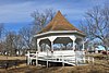 | January 6, 2017 (#16000133) | Eskridge City Park, bet. 4th, 5th, Main & Pine Sts. 38°51′26″N 96°06′34″W / 38.8571°N 96.1094°W / 38.8571; -96.1094 (Eskridge Bandstand) | Eskridge | |
| 6 | Fix Farmstead |  | April 14, 2015 (#15000149) | 34554 Old K-10 Rd. 38°56′57″N 96°24′04″W / 38.9491°N 96.401°W / 38.9491; -96.401 (Fix Farmstead) | Alma vicinity | |
| 7 | Grimm-Schultz Farmstead | 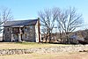 | October 5, 2020 (#100005635) | 35180 Old K-10 Hwy. 38°56′38″N 96°24′41″W / 38.9440°N 96.4115°W / 38.9440; -96.4115 (Grimm-Schultz Farmstead) | Alma | |
| 8 | Mount Mitchell Heritage Prairie Historic District |  | February 17, 2022 (#100007422) | 29377 Mitchell Prairie Ln. 39°08′37″N 96°17′47″W / 39.1436°N 96.2964°W / 39.1436; -96.2964 (Mount Mitchell Heritage Prairie Historic District) | Wamego | |
| 9 | Paxico Historic District |  | October 30, 1998 (#98001289) | 101-103, 105, 107, 109 Newbury St. 39°03′57″N 96°10′07″W / 39.0658°N 96.1686°W / 39.0658; -96.1686 (Paxico Historic District) | Paxico | |
| 10 | Paxico Rural High School |  | July 12, 2022 (#100007925) | 112 Elm St. 39°04′18″N 96°10′06″W / 39.0716°N 96.1682°W / 39.0716; -96.1682 (Paxico Rural High School) | Paxico | |
| 11 | Pearl Opera House |  | August 9, 2024 (#100010620) | 601 Main Street 38°51′51″N 96°29′23″W / 38.8643°N 96.4898°W / 38.8643; -96.4898 (Pearl Opera House) | Alta Vista | |
| 12 | Pratt-Mertz Barn |  | February 3, 2020 (#100004928) | 34107 KS 18 39°09′28″N 96°22′35″W / 39.1577°N 96.3765°W / 39.1577; -96.3765 (Pratt-Mertz Barn) | Manhattan | |
| 13 | Security State Bank |  | May 6, 1982 (#82002678) | Main and 2nd Sts. 38°51′35″N 96°06′29″W / 38.8597°N 96.1081°W / 38.8597; -96.1081 (Security State Bank) | Eskridge | |
| 14 | Snokomo School |  | January 20, 1995 (#94001576) | 8 miles south of Paxico 38°59′22″N 96°06′48″W / 38.9894°N 96.1133°W / 38.9894; -96.1133 (Snokomo School) | Paxico | |
| 15 | Southeast Stone Arch Bridge - Lake Wabaunsee |  | December 30, 2009 (#09001171) | East Flint Hills Dr., 2.2 miles south of K-4 38°51′12″N 96°11′15″W / 38.8533°N 96.1874°W / 38.8533; -96.1874 (Southeast Stone Arch Bridge - Lake Wabaunsee) | Eskridge | |
| 16 | Stuewe House | 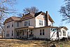 | January 17, 2007 (#06001245) | 617 Nebraska 39°00′55″N 96°17′36″W / 39.0153°N 96.2933°W / 39.0153; -96.2933 (Stuewe House) | Alma | |
| 17 | Sump Barn |  | May 19, 2022 (#100007708) | 26603 K-99 Hwy. 38°58′45″N 96°16′56″W / 38.9791°N 96.2823°W / 38.9791; -96.2823 (Sump Barn) | Alma | |
| 18 | Peter Thoes Barn |  | October 30, 2013 (#13000856) | 25709 Hessdale Rd. 38°57′59″N 96°15′24″W / 38.9665°N 96.2568°W / 38.9665; -96.2568 (Peter Thoes Barn) | Alma | Agriculture-Related Resources of Kansas MPS |
| 19 | Wabaunsee County Courthouse |  | April 26, 2002 (#02000399) | 215 Kansas Ave. 39°00′44″N 96°17′30″W / 39.0122°N 96.2917°W / 39.0122; -96.2917 (Wabaunsee County Courthouse) | Alma | |
| 20 | Wabaunsee District No. 1 Grammar School |  | November 17, 2005 (#05001238) | 56 Center St. 39°08′46″N 96°20′57″W / 39.1461°N 96.3492°W / 39.1461; -96.3492 (Wabaunsee District No. 1 Grammar School) | Wabaunsee |
See also
Wikimedia Commons has media related to National Register of Historic Places in Wabaunsee County, Kansas.
- List of National Historic Landmarks in Kansas
- National Register of Historic Places listings in Kansas
References
- ^ The latitude and longitude information provided in this table was derived originally from the National Register Information System, which has been found to be fairly accurate for about 99% of listings. Some locations in this table may have been corrected to current GPS standards.
- ^ National Park Service, United States Department of the Interior, "National Register of Historic Places: Weekly List Actions", retrieved September 5, 2024.
- ^ Numbers represent an alphabetical ordering by significant words. Various colorings, defined here, differentiate National Historic Landmarks and historic districts from other NRHP buildings, structures, sites or objects.
- ^ "National Register Information System". National Register of Historic Places. National Park Service. March 13, 2009.
- ^ The eight-digit number below each date is the number assigned to each location in the National Register Information System database, which can be viewed by clicking the number.
- v
- t
- e

- Allen
- Anderson
- Atchison
- Barber
- Barton
- Bourbon
- Brown
- Butler
- Chase
- Chautauqua
- Cherokee
- Cheyenne
- Clark
- Clay
- Cloud
- Coffey
- Comanche
- Cowley
- Crawford
- Decatur
- Dickinson
- Doniphan
- Douglas
- Edwards
- Elk
- Ellis
- Ellsworth
- Finney
- Ford
- Franklin
- Geary
- Gove
- Graham
- Grant
- Gray
- Greeley
- Greenwood
- Hamilton
- Harper
- Harvey
- Haskell
- Hodgeman
- Jackson
- Jefferson
- Jewell
- Johnson
- Kearny
- Kingman
- Kiowa
- Labette
- Lane
- Leavenworth
- Lincoln
- Linn
- Logan
- Lyon
- Marion
- McPherson
- Meade
- Miami
- Mitchell
- Montgomery
- Morris
- Morton
- Nemaha
- Neosho
- Ness
- Norton
- Osage
- Osborne
- Ottawa
- Pawnee
- Phillips
- Pottawatomie
- Pratt
- Rawlins
- Reno
- Republic
- Rice
- Riley
- Rooks
- Rush
- Russell
- Saline
- Scott
- Sedgwick
- Seward
- Shawnee
- Sheridan
- Sherman
- Smith
- Stafford
- Stanton
- Stevens
- Sumner
- Thomas
- Trego
- Wabaunsee
- Wallace
- Washington
- Wichita
- Wilson
- Woodson
- Wyandotte
- Archaeological sites
- National Historic Landmarks
 Category
 NRHP portal


Municipalities and communities of Wabaunsee County, Kansas, United States | ||
|---|---|---|
County seat: Alma | ||
| Cities |  | |
| CDPs | ||
| Unincorporated communities | ||
| Ghost towns | ||
| Footnotes | ‡This community also has portions in an adjacent county or counties. | |
| ||


