Offa, Wrexham
Community in Wrexham County Borough, Wales
Human settlement in Wales
- Wrexham
- Clwyd
- Wrexham
- Wrexham

Offa is a community and electoral ward in Wrexham County Borough, Wales, covering most of the south-western portion of the city of Wrexham. It is bordered by the communities of; Rhosddu, and Caia Park to the north, Abenbury to the east, Esclusham, and Marchwiel to the south, and Broughton, Coedpoeth, and Gwersyllt to the west.
Naming
According to Howard Williams and Liam Delaney, a Professor of Archaeology and Doctoral Researcher respectively, at the University of Chester, the area is named after Bryn Offa (Welsh for Offa's Hill), a housing estate and former hall located currently within the community. Bryn Offa itself is actually named after Wat's Dyke which historically passes through the community, as historically there was no distinction between Wat's and Offa's Dyke, leading to local confusion. Williams and Delaney state that such distinction between the two dykes was only made by the nineteenth century at earliest.[1]
History
Unlike many such community areas in Wales, Offa was not based on the boundaries of an earlier civil parish or township, although it corresponds roughly to some of the areas included in the old township of Wrexham Abbott. It was first established only in April 1985, after a boundary review bought four new 'urban' communities into being within the then town of Wrexham.[2] The community has four wards, Erddig, Brynyffynnon, Hermitage, and Offa. The Community Council states that it was noted in a Welsh Assembly report as one of the most "active and innovative" in Wales.[2]
At the 2001 census, the community had a total population of 9,852 in 4,294 households,[3] the population increasing to 10,501 at the 2011 census.[4] Following the Hermitage ward's inclusion in the top 10% of the Welsh Index of Multiple Deprivation, Offa Community has been involved in the Welsh Assembly's Communities First regeneration programme.[5]
Area
Offa is bounded by the A483 dual carriageway to most of its west, stopping before Bersham, where it arbitrarily curves around until reaching the River Clywedog near Bersham Road. The river forms the community's southern boundary until its confluence with the River Dee which continues the border to the King's Mill. It then follows the A525 until reaching Eagles Meadow which via Mount Street it curves around reaching Wrexham's High Street, Regent Street, and the A541 until closing with the A483.
The community of Offa covers much of the south-western part of the city of Wrexham, including St. Giles' Church, Wrexham Central station, Wrexham Maelor Hospital, Wrexham Technology Park, and Bellevue Park. It covers large residential areas, including the areas known as Hightown, Brynyffynnon and Felin Puleston, as well as the part of the grounds of Erddig not within the neighbouring communities of Esclusham, and Marchwiel. Its easternmost sections are regarded to be part of Hightown.
Gallery
-
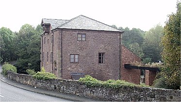 Former King's Mill Visitor Centre on the River Clywedog
 -
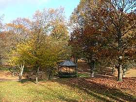 . The Bandstand at Bellevue Park


References
Wikimedia Commons has media related to Offa, Wrexham.
- ^ Williams, Howard; Delaney, Liam (September 2020). "Living after Offa: Place-Names and Social Memory in the Welsh Marches". Offa's Dyke Journal. 2. University of Chester. JAS Arqueologia: 22–24. doi:10.23914/odj.v2i0.274. Archived from the original on 7 July 2024. Retrieved 6 April 2021.
{{cite journal}}: CS1 maint: date and year (link) - ^ a b About Offa Community Council Archived 15 April 2009 at the Wayback Machine, Offa Community Council
- ^ Offa Community Archived 12 June 2011 at the Wayback Machine, Office of National Statistics
- ^ "Community population 2011". Retrieved 19 November 2015.
- ^ Community Regeneration – Teams and Partnerships Archived 21 March 2012 at the Wayback Machine, Wrexham CBC
- v
- t
- e

- Abenbury
- Acton
- Bangor-on-Dee
- Bronington
- Broughton
- Brymbo
- Caia Park
- Cefn
- Ceiriog Ucha
- Chirk
- Coedpoeth
- Erbistock
- Esclusham
- Glyntraian
- Gresford
- Gwersyllt
- Hanmer
- Holt
- Isycoed
- Llangollen Rural
- Llansantffraid Glyn Ceiriog
- Llay
- Maelor South
- Marchwiel
- Minera
- Offa
- Overton
- Pen-y-cae
- Rhosddu
- Rhosllanerchrugog
- Rossett
- Ruabon
- Sesswick
- Willington Worthenbury
- Aberoer
- Acrefair
- Arowry
- Bersham
- Bettisfield
- Borras
- Borras Park
- Bowling Bank
- Bradley
- Bryn Offa
- Brynteg
- Burton
- Bwlchgwyn
- Caego
- Cefn Mawr
- Ceiriog Valley
- Chapel Street
- Charles Street
- Chester Street
- College Street
- Cross Lanes
- Fairy Road
- Froncysyllte
- Garden Village
- Grosvenor Road
- Grove Road
- Glyn Ceiriog
- Gwynfryn
- Halghton
- Hightown
- Horseman's Green
- Island Green
- Johnstown
- Knolton
- Llanarmon Dyffryn Ceiriog
- Llan-y-pwll
- Llwyneinion
- Llwynmawr
- Maelor
- Maelor Saesneg
- Marford
- Moss
- Newbridge
- New Brighton
- New Broughton
- Pandy (Ceiriog)
- Pandy (Gwersyllt)
- Pant
- Penley
- Pentre Broughton
- Pentre Bychan
- Pentre Maelor
- Plas Coch
- Plas Madoc
- Ponciau
- Pontfadog
- Queen's Square
- Rhosnesni
- Rhosrobin
- Rhostyllen
- Rhosymedre
- Ridleywood
- Salisbury Park/Road
- Southsea
- Stansty
- Summerhill
- Sydallt
- Tanyfron
- Temple Row
- Tregeiriog
- Trevor
- Tybroughton
- Wrexham Industrial Estate
- Wrexham City Centre
- Whitewell
- 2 Grosvenor Road
- Abbotsfield
- All Saints' Church, Gresford
- Bangor-on-Dee Bridge
- Bangor-on-Dee racecourse
- Bersham Ironworks
- Bridge End Inn
- Brynkinalt Hall
- Butchers' Market
- Cathedral of Our Lady of Sorrows
- Cefn Viaduct
- Central Arcade
- Chirk Aqueduct
- Chirk Viaduct
- Chirk War Memorial
- County Buildings
- Croesnewydd Hall
- Eagles Meadow
- Elephant and Castle
- Erddig
- Feathers Hotel
- The Gelli
- Hightown Barracks
- HM Prison Berwyn
- Horse and Jockey
- Holt Bridge
- General Market
- Gresford Methodist Church
- Grosvenor Lodge
- Grove Park School
- Iscoyd Park
- Marchwiel Hall
- Nags Head (Wrexham)
- Offa's Dyke (part)
- Old Carnegie Library
- Old Wrexham Infirmary
- Overton Arcade
- Pant-yr-Ochain
- Pen-y-Lan Hall
- Pont Cysyllte
- Pontcysyllte Aqueduct
- Poyser Street drill hall
- Rossett Presbyterian Chapel
- Racecourse Ground
- Rossett Hall
- Saith Seren
- Soames Brewery Chimney
- St David's Welsh Church (Rhosllanerchrugog)
- St Giles' Church
- The Midland
- Talbot Hotel
- Trevalyn Hall
- Trinity Presbyterian Church
- Tudor Court
- Turf Hotel
- Tŷ Pawb
- Wat's Dyke (part)
- Waking the Dragon (proposed)
- War Memorial Hospital
- Waterworld
- Wrexham bus station
- Wrexham Cemetery
- Wrexham Lager Brewery
- Wrexham Library
- Wrexham Guildhall
- Wrexham Maelor Hospital
- Wrexham Police Station (1973–2020)
- Wynn Hall
- Wynnstay
- Wynnstay Arms (Ruabon)
- Wynnstay Arms (Wrexham)
- Xplore!
| Castles |
|
|---|
| Rivers | |
|---|---|
| Reservoirs and lakes |
|
- Wrexham bus station
- A5 road
- A483 road
- A525 road
- A528 road
- A541 road
- B5101 road
- Chester and Wrexham Turnpike (former)
- Llangollen Canal
- Trevor Basin
- Wrexham & Shropshire (former)
- North Wales Metro (part)
| Railway lines | |
|---|---|
| Former lines |
|
| Railway stations |
- Calon FM
- Capital North West and North Wales
- Heart North Wales
- Capital Cymru (some broadcasts)
- Smooth Wales (some broadcasts)
- MuxCo (radio operator)
- Wrexham-Rhos transmitting station
- Marcher Radio Group (former)
- BBC Cymru Wales (local studios)
- The Leader newspaper
- Wales Comic Con (2008–2019; 2022)
- Focus Wales
- Parliamentary constituencies
- Schools
- City parks and open spaces
- Council elections
- SSSIs
- Country houses
- Listed buildings
- Scheduled monuments
- Listed parks and gardens
- History
- Former RAF Wrexham
- Lord Lieutenants
- High Sheriffs
- Mayor
- Museums
- Wrexham Library
- Wrexham Guildhall
- Public art
- Wrexham Art School
- Wrexham A.F.C.
- Wrexham RFC
- Preserved county of Clwyd
- Historic counties of Denbighshire and Flintshire


