Saint Urbain Street
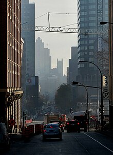 Saint Urbain Street in Downtown Montreal. | |
| Native name | rue Saint-Urbain (French) |
|---|---|
| Location | Montreal |
| South end | Saint-Antoine Street, Old Montreal |
| Major junctions |  R-138 Sherbrooke Street R-138 Sherbrooke Street |
| North end | Gouin Boulevard, Ahuntsic |
| Construction | |
| Inauguration | 1817 |
Saint Urbain Street (French: rue Saint-Urbain) is a major one-way street located in Montreal, Quebec, Canada. The original, southernmost section of the street was built by Urbain Tessier (c. 1624–1689), a farmer and carpenter who settled in the area. The name also makes reference to Saint Urbain.
In the late 18th and early 19th centuries, the street, now stretching northward, was home to several of Montreal's prominent British and French merchants, notably the explorer Alexander Henry the elder. By the turn of the 20th century, sections of the street were industrialised and became run down, and were settled by Jews, predominantly from Eastern Europe. Writer Mordecai Richler immortalised the Mile End section as a centre of the Jewish community in Montreal, and he documented the life there in novels such as St. Urbain's Horseman.[1]
From roughly 1970 onwards, the Jewish community uprooted to Outremont and the street was settled by Greek, Portuguese and Caribbean immigrants.[2] Today, much of the street has been gentrified.
Place-d'Armes station is located on the street while the Place-des-Arts station and De Castelnau station are right nearby.
It traverses the boroughs of Ville-Marie, Le Plateau-Mont-Royal, Rosemont–La Petite-Patrie, Villeray–Saint-Michel–Parc-Extension and Ahuntsic-Cartierville.
See also
References
External links
![]() Media related to Saint Urbain Street, Montreal at Wikimedia Commons
Media related to Saint Urbain Street, Montreal at Wikimedia Commons
- v
- t
- e
- Boulevard Saint-Charles
- Boulevard Saint-Jean
- Boulevard Des Sources
- Laurentian Boulevard
- Décarie Boulevard
- Greene Avenue
- Atwater Avenue
- Côte-des-Neiges Road
- Guy Street
- Mackay Street
- Bishop Street
- Crescent Street
- Mountain Street
- Drummond Street
- Stanley Street
- Peel Street
- Metcalfe Street
- McTavish Street
- Mansfield Street
- McGill College Avenue
- Robert-Bourassa Boulevard / University Street
- McGill Street
- Park Avenue
- Jeanne-Mance Street
- Saint Urbain Street
- Saint Laurent Boulevard
- Saint Denis Street
- Berri Street
- Saint Hubert Street
- Christophe Colomb Avenue
- Papineau Avenue
- De Lorimier Avenue
- D'Iberville Street
- Saint-Michel Boulevard
- Pie-IX Boulevard
- Lacordaire Boulevard
- De L'Assomption Boulevard
- Langelier Boulevard
- Rue de la Commune
- Wellington Street
- Saint Patrick Street
- Saint-Paul Street
- Notre-Dame Street
- Saint Jacques Street
- Saint Antoine Street
- De la Gauchetière Street
- René Lévesque Boulevard
- Saint Catherine Street
- De Maisonneuve Boulevard
- Ontario Street
- Sherbrooke Street
- Doctor Penfield Avenue
- Pine Avenue
- Mount Royal Avenue
- Saint Joseph Boulevard
- Laurier Avenue
- Côte-Saint-Luc Road
- Queen Mary Road
- Côte-Sainte-Catherine Road
- Beaubien Street
- Van Horne Avenue
- Jean Talon Street
- Jarry Street
- Côte-Vertu Boulevard
- Henri Bourassa Boulevard
- Pierrefonds Boulevard
- Gouin Boulevard
- LaSalle Boulevard
 Category
 WikiProject

45°30′33″N 73°33′56″W / 45.509084°N 73.565564°W / 45.509084; -73.565564
 | This Montreal-related article is a stub. You can help Wikipedia by expanding it. |
- v
- t
- e
 | This Quebec road, road transport or highway-related article is a stub. You can help Wikipedia by expanding it. |
- v
- t
- e


