Tamanrasset District
District in Tamanrasset, Algeria
Tamanrasset District دائرة تمنراست | |
|---|---|
District | |
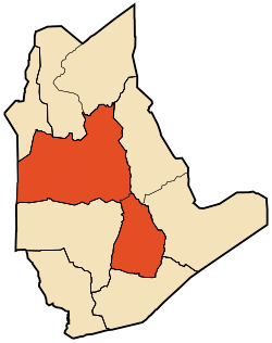 Map of Tamanrasset District | |
| Coordinates: 22°47′N 5°31′E / 22.783°N 5.517°E / 22.783; 5.517 | |
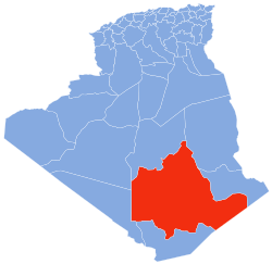
| Country |  Algeria Algeria |
| Province | Tamanrasset |
| District seat | Tamanrasset |
| Area | |
| • Total | 131,151 km2 (50,638 sq mi) |
| Population (2008)[1] | |
| • Total | 96,843 |
| • Density | 0.74/km2 (1.9/sq mi) |
| Time zone | UTC+01 (CET) |
| Municipalities | 2 |
Tamanrasset is a district in Tamanrasset Province, Algeria. It was named after its capital, Tamanrasset, which is also the capital of the province. With 96,843 people,[1] it is the most populated district in the province (however, the population density is low) and one of the largest districts in the country.
Municipalities
The district is further divided into 2 municipalities:[2]
- Tamanrasset
- In Amguel
References
- ^ a b "Population: Wilaya de Tamanrasset" (PDF) (in French). Office National des Statistiques Algérie. Retrieved 30 May 2013.
- ^ "Décret executif n° 91-306 du 24 août 1991 fixant la liste des communes animées par cheque chef de daïra. Wilaya d'El Oued" (PDF) (in French). Journal officiel de la République Algérienne. 4 September 1991. p. 1299. Archived from the original (PDF) on 2011-02-23. Retrieved 30 May 2013.
- v
- t
- e
Tamanrasset Province
| |
 | This article about a location in Tamanrasset Province is a stub. You can help Wikipedia by expanding it. |
- v
- t
- e


