Tefert El Tahtania
Village in Tamanrasset Province, Algeria
Tefert El Tahtania تيفرت | |
|---|---|
Village | |
| 22°51′22″N 4°54′39″E / 22.85611°N 4.91083°E / 22.85611; 4.91083 | |
| Country |  Algeria Algeria |
| Province | Tamanrasset Province |
| District | Abalessa District |
| Commune | Abalessa[1] |
| Elevation | 923 m (3,028 ft) |
| Time zone | UTC+1 (CET) |
Tefert El Tahtania is a village in the commune of Abalessa,[1] in Tamanrasset Province, Algeria. It lies on the southern bank of Oued Teffert[2] 8 kilometres (5.0 mi) southeast of Abalessa and 64 kilometres (40 mi) west of Tamanrasset.[3]
References
- ^ a b "Décret n° 84-365, fixant la composition, la consistance et les limites territoriale des communes. Wilaya d'El Oued" (PDF) (in French). Journal officiel de la République Algérienne. 19 December 1984. p. 1496. Archived from the original (PDF) on 4 June 2013. Retrieved 6 June 2013.
- ^ "Oued Teffert, Algeria". Geonames.org. Retrieved 27 June 2013.
- ^ "تيفرت لغربية, ولاية تمنراست, الجزائر". Google Maps. Retrieved 27 June 2013.
Neighbouring towns and cities
- v
- t
- e
Places adjacent to Tefert El Tahtania
| Abalessa | In Amguel Iglène | Idlès Tarhenanet |
 | ||
 Tefert El Tahtania Tefert El Tahtania | Issalissekine Tamanrasset | |
 | ||
| Silet Tin Zaouatine | In Guezzam | Tefert El Fougania |
| ||||||
|---|---|---|---|---|---|---|
| Tamanrasset District | 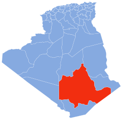 | |||||
| In Salah District | ||||||
| Tazrouk District | ||||||
| Abalessa District |
| |||||
| In Ghar District | ||||||
| Tin Zaouatine District | ||||||
| In Guezzam District | ||||||
 | This article about a location in Tamanrasset Province is a stub. You can help Wikipedia by expanding it. |
- v
- t
- e


