Grade I listed buildings in King's Lynn and West Norfolk
Map all coordinates using OpenStreetMap
Download coordinates as:
- KML
- GPX (all coordinates)
- GPX (primary coordinates)
- GPX (secondary coordinates)
There are over 9,000 Grade I listed buildings in England. This page is a list of these buildings in the district of King's Lynn and West Norfolk in Norfolk.
King's Lynn and West Norfolk
| Name | Location | Type | Completed [note 1] | Date designated | Grid ref.[note 2] Geo-coordinates | Entry number [note 3] | Image |
|---|---|---|---|---|---|---|---|
| Church of St Andrew | Barton Bendish | Parish Church | c. 1200 | 8 July 1959 | TF7121705687 52°37′19″N 0°31′41″E / 52.621948°N 0.527944°E / 52.621948; 0.527944 (Church of St Andrew) | 1077860 |  More images |
| Church of St Mary | Barton Bendish | Parish Church | 14th century | 8 July 1959 | TF7097705437 52°37′11″N 0°31′27″E / 52.619778°N 0.524273°E / 52.619778; 0.524273 (Church of St Mary) | 1077859 | 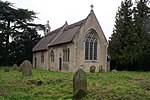 More images |
| Ruins of Church of St James at TF 662 207 | Bawsey | Parish Church | 11th century | 20 June 1988 | TF6620020700 52°45′30″N 0°27′41″E / 52.758342°N 0.461478°E / 52.758342; 0.461478 (Ruins of Church of St James at TF 662 207) | 1077664 | 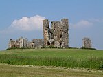 More images |
| Church of St Mary | Great Bircham, Bircham | Parish Church | Early 14th century | 5 June 1953 | TF7704632600 52°51′42″N 0°37′42″E / 52.861763°N 0.628468°E / 52.861763; 0.628468 (Church of St Mary) | 1077807 |  More images |
| Church of St Mary | Brancaster | Parish Church | 12th century | 5 June 1953 | TF7724543900 52°57′47″N 0°38′15″E / 52.963169°N 0.637581°E / 52.963169; 0.637581 (Church of St Mary) | 1237744 |  More images |
| Church of St Mary | Burnham Market | Church | c. 1500 | 5 June 1953 | TF8302242092 52°56′42″N 0°43′21″E / 52.944996°N 0.722471°E / 52.944996; 0.722471 (Church of St Mary) | 1238100 |  More images |
| Church of St Margaret | Burnham Norton | Parish Church | Late 11th century | 5 June 1953 | TF8350142760 52°57′03″N 0°43′48″E / 52.950831°N 0.729969°E / 52.950831; 0.729969 (Church of St Margaret) | 1238877 | 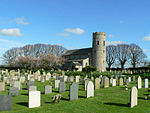 More images |
| Gatehouse, Carmelite Friary Ruins | Burnham Norton | Carmelite Friary | 1241 | 5 June 1953 | TF8381542777 52°57′03″N 0°44′05″E / 52.950876°N 0.734647°E / 52.950876; 0.734647 (Gatehouse, Carmelite Friary Ruins) | 1239045 |  More images |
| Church of St Clement | Burnham Overy Town, Burnham Overy | Parish Church | 12th century | 5 June 1953 | TF8430342929 52°57′07″N 0°44′31″E / 52.952074°N 0.741988°E / 52.952074; 0.741988 (Church of St Clement) | 1239094 |  More images |
| Church of All Saints | Burnham Thorpe | Parish Church | 13th century | 5 June 1953 | TF8521641752 52°56′28″N 0°45′18″E / 52.941192°N 0.75489°E / 52.941192; 0.75489 (Church of All Saints) | 1239270 |  More images |
| Bailey Gate | Castle Acre | Castle Gate | 13th century | 13 April 1987 | TF8173115150 52°42′13″N 0°41′18″E / 52.70351°N 0.688299°E / 52.70351; 0.688299 (Bailey Gate) | 1077681 | 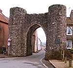 More images |
| Castle Acre Castle | Castle Acre | Castle Keep | Mid 12th century | 13 April 1987 | TF8192015169 52°42′13″N 0°41′28″E / 52.703617°N 0.691103°E / 52.703617; 0.691103 (Castle Acre Castle) | 1171480 | 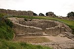 More images |
| Church of St James | Castle Acre | Parish Church | c. 1300 | 15 August 1960 | TF8159815022 52°42′09″N 0°41′11″E / 52.702405°N 0.686262°E / 52.702405; 0.686262 (Church of St James) | 1342386 |  More images |
| Remains of Cluniac Benedictine Priory of St Mary and St Peter and St Paul | Castle Acre | Priory (ruin) | Norman | 13 April 1987 | TF8142614757 52°42′00″N 0°41′01″E / 52.700083°N 0.683573°E / 52.700083; 0.683573 (Remains of Cluniac Benedictine Priory of St Mary and St Peter and St Paul) | 1342389 |  More images |
| Remains of Gatehouse of Cluniac Priory of St Mary and St Peter and St Paul | Castle Acre | Gatehouse (ruin) | 1090 | 13 April 1987 | TF8136414940 52°42′06″N 0°40′58″E / 52.701747°N 0.682758°E / 52.701747; 0.682758 (Remains of Gatehouse of Cluniac Priory of St Mary and St Peter and St Paul) | 1171437 |  More images |
| Church of St Lawrence | Castle Rising | Parish Church | 12th century | 15 August 1960 | TF6663824866 52°47′44″N 0°28′12″E / 52.795623°N 0.470081°E / 52.795623; 0.470081 (Church of St Lawrence) | 1077602 | 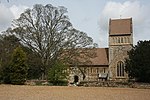 More images |
| Ruins of Castle and Eleventh Century Church | Castle Rising | Castle | c. 1138 | 21 February 1989 | TF6657624554 52°47′34″N 0°28′08″E / 52.79284°N 0.469004°E / 52.79284; 0.469004 (Ruins of Castle and Eleventh Century Church) | 1077599 | 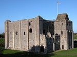 More images |
| Trinity Hospital (hospital of the Holy and Undivided Trinity) and attached Enclosing Walls, Circa 30 Metres East of Church of St | Castle Rising | Almshouses | 1609-15 | 19 October 1951 | TF6668624865 52°47′44″N 0°28′15″E / 52.795599°N 0.470792°E / 52.795599; 0.470792 (Trinity Hospital (hospital of the Holy and Undivided Trinity) and attached Enclosing Walls, Circa 30 Metres East of Church of St) | 1342436 |  More images |
| Church of St Nicholas | Dersingham | Parish Church | 14th century | 5 June 1953 | TF6931130386 52°50′40″N 0°30′45″E / 52.844366°N 0.512544°E / 52.844366; 0.512544 (Church of St Nicholas) | 1342317 | 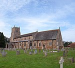 More images |
| Church of St Edmund | Downham Market | Church | 15th century | 24 February 1949 | TF6127903305 52°36′13″N 0°22′48″E / 52.603593°N 0.380112°E / 52.603593; 0.380112 (Church of St Edmund) | 1342608 | 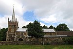 More images |
| Church of St Mary | East Walton | Parish Church | 12th century | 15 August 1960 | TF7426716112 52°42′53″N 0°34′42″E / 52.714601°N 0.578461°E / 52.714601; 0.578461 (Church of St Mary) | 1077667 |  More images |
| Church of St Edmund | Emneth | Parish Church | c. 1210 | 11 August 1951 | TF4885307383 52°38′38″N 0°11′55″E / 52.643769°N 0.198611°E / 52.643769; 0.198611 (Church of St Edmund) | 1077736 |  More images |
| Church of St Mary | Feltwell | Parish Church | Mid 14th century | 8 July 1959 | TL7151890738 52°29′15″N 0°31′29″E / 52.487595°N 0.524664°E / 52.487595; 0.524664 (Church of St Mary) | 1077715 |  More images |
| Church of St Nicholas | Feltwell | Parish Church (redundant) | 12th century | 8 July 1959 | TL7125690890 52°29′21″N 0°31′15″E / 52.489042°N 0.520888°E / 52.489042; 0.520888 (Church of St Nicholas) | 1342364 |  More images |
| Church of St Martin | Fincham | Parish Church | Mid 15th century | 8 July 1959 | TF6880106458 52°37′47″N 0°29′34″E / 52.629628°N 0.492683°E / 52.629628; 0.492683 (Church of St Martin) | 1077822 |  More images |
| Church of St Mary | Gayton Thorpe, Gayton | Parish Church | Early 12th century | 15 August 1960 | TF7450218526 52°44′10″N 0°35′00″E / 52.736204°N 0.583217°E / 52.736204; 0.583217 (Church of St Mary) | 1077632 |  More images |
| Church of St Nicholas | Gayton | Church | 1604 | 15 August 1960 | TF7302219262 52°44′36″N 0°33′42″E / 52.743289°N 0.561708°E / 52.743289; 0.561708 (Church of St Nicholas) | 1077638 |  More images |
| Church of St Mary | Great Massingham | Parish Church | 13th century | 15 August 1960 | TF7987422949 52°46′27″N 0°39′54″E / 52.774163°N 0.665117°E / 52.774163; 0.665117 (Church of St Mary) | 1171571 | 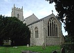 More images |
| Church of St Botolph | Grimston | Parish Church | 13th century | 15 August 1960 | TF7217021891 52°46′02″N 0°33′02″E / 52.767171°N 0.550479°E / 52.767171; 0.550479 (Church of St Botolph) | 1342401 |  More images |
| Church of St Lawrence | Harpley | Parish Church | 13th century | 15 August 1960 | TF7887126067 52°48′09″N 0°39′07″E / 52.802495°N 0.651969°E / 52.802495; 0.651969 (Church of St Lawrence) | 1077655 |  More images |
| Church of St James | Hockwold cum Wilton | Parish Church | Early 14th century | 8 July 1959 | TL7346888008 52°27′45″N 0°33′07″E / 52.46246°N 0.551933°E / 52.46246; 0.551933 (Church of St James) | 1077725 |  More images |
| Church of St Peter | Hockwold cum Wilton | Parish Church | Mid 14th century | 8 July 1959 | TL7249188015 52°27′46″N 0°32′15″E / 52.462833°N 0.537572°E / 52.462833; 0.537572 (Church of St Peter) | 1306877 | 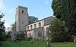 More images |
| Church of St Mary | Holme-next-the-Sea | Parish Church | Perpendicular | 5 June 1953 | TF7070443429 52°57′40″N 0°32′24″E / 52.961059°N 0.54005°E / 52.961059; 0.54005 (Church of St Mary) | 1171431 | 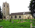 More images |
| Church of St Martin | Houghton Park, Houghton Hall, Houghton | Parish Church | 14th century | 5 June 1953 | TF7937028382 52°49′23″N 0°39′38″E / 52.823118°N 0.660632°E / 52.823118; 0.660632 (Church of St Martin) | 1077787 |  More images |
| Houghton Hall with Courtyard Walls Attached to North and South | Houghton Park, Houghton | Country House | 1722-1735 | 5 June 1953 | TF7916528789 52°49′37″N 0°39′28″E / 52.826841°N 0.657816°E / 52.826841; 0.657816 (Houghton Hall with Courtyard Walls Attached to North and South) | 1152645 |  More images |
| The Square, Houghton Hall | Houghton Park, Houghton | Stables | c. 1900 | 9 October 1985 | TF7904728600 52°49′31″N 0°39′21″E / 52.825183°N 0.655963°E / 52.825183; 0.655963 (The Square, Houghton Hall) | 1152782 |  More images |
| The Watertower | Houghton Park, Houghton Hall, Houghton | Water Tower | c. 1733 | 9 October 1985 | TF7899229464 52°49′59″N 0°39′20″E / 52.832959°N 0.655621°E / 52.832959; 0.655621 (The Watertower) | 1342318 |  More images |
| Church of St Andrew | Little Massingham | Parish Church | 14th century | 15 August 1960 | TF7925824149 52°47′07″N 0°39′24″E / 52.785144°N 0.656653°E / 52.785144; 0.656653 (Church of St Andrew) | 1171638 |  More images |
| Church of Holy Trinity | Marham | Parish Church | 12th century | 8 July 1959 | TF7081509737 52°39′30″N 0°31′27″E / 52.658447°N 0.524106°E / 52.658447; 0.524106 (Church of Holy Trinity) | 1077832 |  More images |
| Church of St George | Methwold | Church | 1721 | 8 July 1959 | TL7323794827 52°31′26″N 0°33′07″E / 52.523775°N 0.552082°E / 52.523775; 0.552082 (Church of St George) | 1077730 |  More images |
| The Old Vicarage | Methwold | House | 16th century | 9 July 1951 | TL7321694764 52°31′24″N 0°33′06″E / 52.523216°N 0.55174°E / 52.523216; 0.55174 (The Old Vicarage) | 1342369 |  More images |
| Middleton Tower | Tower End, Middleton | House | c. 1455 | 19 October 1951 | TF6686817564 52°43′48″N 0°28′11″E / 52.729972°N 0.469774°E / 52.729972; 0.469774 (Middleton Tower) | 1077649 |  More images |
| Church of St Mary | North Creake | Parish Church | c. 1300 | 5 June 1953 | TF8541037729 52°54′18″N 0°45′20″E / 52.905003°N 0.755477°E / 52.905003; 0.755477 (Church of St Mary) | 1077816 |  More images |
| Creake Abbey Farmhouse | North Creake | Abbey | Medieval | 5 June 1953 | TF8561539450 52°55′13″N 0°45′34″E / 52.920385°N 0.759504°E / 52.920385; 0.759504 (Creake Abbey Farmhouse) | 1342331 |  Upload Photo |
| Garden Walls Attached to North of Creake Abbey Farmhouse | North Creake | Abbey | Medieval | 18 April 1985 | TF8561539475 52°55′14″N 0°45′34″E / 52.920609°N 0.759519°E / 52.920609; 0.759519 (Garden Walls Attached to North of Creake Abbey Farmhouse) | 1304717 | Upload Photo |
| Remains of Creake Abbey Church | North Creake | Abbey | 1206-1507 | 5 June 1953 | TF8561339490 52°55′15″N 0°45′34″E / 52.920744°N 0.759497°E / 52.920744; 0.759497 (Remains of Creake Abbey Church) | 1077815 |  More images |
| Church of All Saints | North Runcton | Parish Church | 1713 | 15 August 1960 | TF6465015901 52°42′57″N 0°26′10″E / 52.715715°N 0.436126°E / 52.715715; 0.436126 (Church of All Saints) | 1342408 |  More images |
| Church of St Andrew | Northwold | Parish Church | 13th century | 8 July 1959 | TL7558197006 52°32′33″N 0°35′16″E / 52.542595°N 0.587745°E / 52.542595; 0.587745 (Church of St Andrew) | 1342348 |  More images |
| Church of St Mary | Old Hunstanton | Parish Church | c. 1860 | 5 June 1953 | TF6890541980 52°56′55″N 0°30′45″E / 52.948615°N 0.512539°E / 52.948615; 0.512539 (Church of St Mary) | 1077920 |  More images |
| Detached Porch in Courtyard, Hunstanton Hall | Old Hunstanton | Country House | 1618 | 5 June 1953 | TF6917641823 52°56′50″N 0°30′59″E / 52.94712°N 0.516487°E / 52.94712; 0.516487 (Detached Porch in Courtyard, Hunstanton Hall) | 1077922 | Upload Photo |
| Entrance Gate Curtain Walls and Barn to East of Hunstanton Hall | Old Hunstanton | Gate | 1623 | 20 September 1984 | TF6924041814 52°56′49″N 0°31′03″E / 52.947019°N 0.517434°E / 52.947019; 0.517434 (Entrance Gate Curtain Walls and Barn to East of Hunstanton Hall) | 1171822 |  |
| Hunstanton Hall Moat, Bridge and Garden and Forecourt Walls | Old Hunstanton | Country House | 1487 | 5 June 1953 | TF6919241813 52°56′49″N 0°31′00″E / 52.947025°N 0.51672°E / 52.947025; 0.51672 (Hunstanton Hall Moat, Bridge and Garden and Forecourt Walls) | 1171725 | More images |
| Church of St Clement | Outwell | Parish Church | 13th century | 11 August 1951 | TF5137203664 52°36′35″N 0°14′03″E / 52.609666°N 0.234108°E / 52.609666; 0.234108 (Church of St Clement) | 1171520 |  More images |
| Church of St Mary Magdalene | Pentney | Parish Church | 12th century | 15 August 1960 | TF7208213856 52°41′42″N 0°32′42″E / 52.695039°N 0.544969°E / 52.695039; 0.544969 (Church of St Mary Magdalene) | 1077623 |  More images |
| Remains of Augustinian Priory | Pentney | Augustinian Monastery | c. 1130 | 19 October 1951 | TF7009612155 52°40′49″N 0°30′53″E / 52.680389°N 0.514733°E / 52.680389; 0.514733 (Remains of Augustinian Priory) | 1342419 |  More images |
| Church of St James | Runcton Holme | Parish Church | Early 12th century | 8 July 1959 | TF6172709488 52°39′32″N 0°23′23″E / 52.658995°N 0.389746°E / 52.658995; 0.389746 (Church of St James) | 1077884 |  More images |
| Wallington Hall | Runcton Holme | Country House | Mid 18th century | 9 July 1951 | TF6272307588 52°38′30″N 0°24′13″E / 52.641632°N 0.403522°E / 52.641632; 0.403522 (Wallington Hall) | 1342286 | Upload Photo |
| Ruins of Church of St Felix at TF 666 261 | Sandringham | Parish Church | 14th century | 15 August 1960 | TF6660026100 52°48′24″N 0°28′13″E / 52.806718°N 0.470146°E / 52.806718; 0.470146 (Ruins of Church of St Felix at TF 666 261) | 1168733 |  More images |
| Church of St Mary | Sedgeford | Parish Church | 12th century | 5 June 1953 | TF7072036483 52°53′55″N 0°32′12″E / 52.898676°N 0.536637°E / 52.898676; 0.536637 (Church of St Mary) | 1172064 |  More images |
| Church of All Saints | Shouldham | Parish Church | 14th century | 8 July 1959 | TF6812708903 52°39′06″N 0°29′02″E / 52.651796°N 0.483979°E / 52.651796; 0.483979 (Church of All Saints) | 1152173 |  More images |
| Church of St Mary | Snettisham | Parish Church | Late 14th century | 5 June 1953 | TF6904834281 52°52′46″N 0°30′38″E / 52.879428°N 0.510662°E / 52.879428; 0.510662 (Church of St Mary) | 1304420 |  More images |
| Church of St Mary | South Creake | Parish Church | 13th century | 5 June 1953 | TF8552636232 52°53′29″N 0°45′23″E / 52.891521°N 0.756347°E / 52.891521; 0.756347 (Church of St Mary) | 1077798 |  More images |
| Church of All Saints | Stanhoe | Parish Church | 13th century | 5 June 1953 | TF8020436880 52°53′57″N 0°40′40″E / 52.899148°N 0.677691°E / 52.899148; 0.677691 (Church of All Saints) | 1304643 |  More images |
| Stanhoe Hall | Stanhoe | House | 1703 | 5 June 1953 | TF7999736991 52°54′01″N 0°40′29″E / 52.900214°N 0.674678°E / 52.900214; 0.674678 (Stanhoe Hall) | 1342334 | Upload Photo |
| Church of Holy Trinity | Stow Bardolph | Parish Church | 12th century | 8 July 1959 | TF6284005645 52°37′27″N 0°24′15″E / 52.624145°N 0.404292°E / 52.624145; 0.404292 (Church of Holy Trinity) | 1342291 |  More images |
| Church of St Mary | Syderstone | Parish Church | 12th century | 5 June 1953 | TF8330432665 52°51′37″N 0°43′17″E / 52.860254°N 0.721351°E / 52.860254; 0.721351 (Church of St Mary) | 1153280 |  More images |
| Church of Saint Clement | Terrington St Clement | Church | 13th century | 11 August 1951 | TF5520420436 52°45′33″N 0°17′55″E / 52.759239°N 0.298552°E / 52.759239; 0.298552 (Church of Saint Clement) | 1237112 |  More images |
| Tower to Church of Saint Clement | Terrington St. Clement | Bell Tower | 1501-1527 | 24 June 1987 | TF5518620451 52°45′34″N 0°17′54″E / 52.759379°N 0.298292°E / 52.759379; 0.298292 (Tower to Church of Saint Clement) | 1264263 |  More images |
| Church of Saint John | Terrington St John | Bell Tower | Late 13th century | 11 August 1951 | TF5393115853 52°43′06″N 0°16′39″E / 52.718436°N 0.277556°E / 52.718436; 0.277556 (Church of Saint John) | 1264266 |  More images |
| Church of All Saints | Thornham | Parish Church | 13th century | 5 June 1953 | TF7337143446 52°57′37″N 0°34′47″E / 52.960357°N 0.579723°E / 52.960357; 0.579723 (Church of All Saints) | 1342296 |  More images |
| Church of All Saints | Tilney All Saints | Parish Church | Late 12th century | 11 August 1951 | TF5683717973 52°44′12″N 0°19′18″E / 52.736645°N 0.321553°E / 52.736645; 0.321553 (Church of All Saints) | 1264202 |  More images |
| Church of St Mary | Titchwell | Parish Church | 12th century | 5 June 1953 | TF7622043874 52°57′48″N 0°37′20″E / 52.963273°N 0.622323°E / 52.963273; 0.622323 (Church of St Mary) | 1273641 |  More images |
| Church of St Peter | Upwell | Parish Church | 13th century | 11 August 1951 | TF5059302780 52°36′07″N 0°13′20″E / 52.601941°N 0.222211°E / 52.601941; 0.222211 (Church of St Peter) | 1342359 | 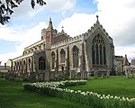 More images |
| Church of St Andrew | Walpole | Church | Earlier Material | 11 August 1951 | TF5016217558 52°44′05″N 0°13′21″E / 52.73481°N 0.22258°E / 52.73481; 0.22258 (Church of St Andrew) | 1264158 | 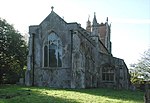 More images |
| Church of St Peter | Walpole | Parish Church | Early 14th century | 11 August 1951 | TF5021216879 52°43′43″N 0°13′23″E / 52.728697°N 0.223009°E / 52.728697; 0.223009 (Church of St Peter) | 1264167 | 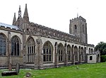 More images |
| Church of All Saints | Walsoken | Church | C20 | 11 August 1951 | TF4772010544 52°40′21″N 0°11′00″E / 52.672475°N 0.183293°E / 52.672475; 0.183293 (Church of All Saints) | 1171765 | 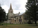 More images |
| Church of Ss Peter and Paul | Watlington | Parish Church | Late 13th century | 8 July 1959 | TF6210711195 52°40′27″N 0°23′46″E / 52.674214°N 0.396198°E / 52.674214; 0.396198 (Church of Ss Peter and Paul) | 1077890 |  More images |
| Church of All Saints | West Acre | Parish Church | 14th century | 15 August 1960 | TF7808015237 52°42′20″N 0°38′04″E / 52.705503°N 0.634372°E / 52.705503; 0.634372 (Church of All Saints) | 1342409 |  More images |
| High House | West Acre | Country House | Mid 18th century | 19 October 1951 | TF7928418126 52°43′52″N 0°39′13″E / 52.731049°N 0.653746°E / 52.731049; 0.653746 (High House) | 1305453 |  More images |
| High House Stable Court and Curtain Wall Attached at East of High House | West Acre | Brewery | c. 1829 | 13 April 1987 | TF7934618152 52°43′53″N 0°39′17″E / 52.731262°N 0.654678°E / 52.731262; 0.654678 (High House Stable Court and Curtain Wall Attached at East of High House) | 1342411 | Upload Photo |
| West Acre Priory Gatehouse | West Acre | Augustinian Monastery | c. 1100 | 19 October 1951 | TF7805015231 52°42′20″N 0°38′02″E / 52.705459°N 0.633925°E / 52.705459; 0.633925 (West Acre Priory Gatehouse) | 1077660 |  More images |
| Church of St Andrew | West Dereham | Church | 1710 | 8 July 1959 | TF6674602104 52°35′28″N 0°27′37″E / 52.591157°N 0.460157°E / 52.591157; 0.460157 (Church of St Andrew) | 1170580 |  More images |
| Church of St Peter | West Rudham | Parish Church | 13th century | 5 June 1953 | TF8195327642 52°48′56″N 0°41′55″E / 52.815608°N 0.698509°E / 52.815608; 0.698509 (Church of St Peter) | 1153338 |  More images |
| Bell Tower of Church of St Mary | West Walton | Bell Tower | 1240-1250 | 28 July 1986 | TF4712613318 52°41′51″N 0°10′33″E / 52.697555°N 0.175753°E / 52.697555; 0.175753 (Bell Tower of Church of St Mary) | 1171875 |  More images |
| Church of St Mary | West Walton | Parish Church | c1240-1250 | 11 August 1951 | TF4711313361 52°41′53″N 0°10′32″E / 52.697945°N 0.17558°E / 52.697945; 0.17558 (Church of St Mary) | 1077676 |  More images |
| Church of St Germans | Wiggenhall St Germans | Parish Church | 13th century | 8 July 1959 | TF5969314015 52°42′01″N 0°21′43″E / 52.700259°N 0.361894°E / 52.700259; 0.361894 (Church of St Germans) | 1077892 |  More images |
| Church of St Mary the Virgin | Wiggenhall St Germans | Parish Church | 13th century | 8 July 1959 | TF5826414404 52°42′15″N 0°20′27″E / 52.704172°N 0.340952°E / 52.704172; 0.340952 (Church of St Mary the Virgin) | 1342293 |  More images |
| Church of St Mary Magdalen | Wiggenhall St Mary Magdalen | Parish Church | 13th century | 8 July 1959 | TF5986411374 52°40′35″N 0°21′47″E / 52.676487°N 0.363141°E / 52.676487; 0.363141 (Church of St Mary Magdalen) | 1077896 |  More images |
| Church of St Botolph | Wormegay | Parish Church | Mid 12th century | 26 April 1985 | TF6530210904 52°40′14″N 0°26′36″E / 52.670636°N 0.443261°E / 52.670636; 0.443261 (Church of St Botolph) | 1077838 | 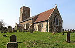 More images |
| Chapel of St Nicholas | King's Lynn | Chapel of Ease | 1146 | 1 December 1951 | TF6185320455 52°45′27″N 0°23′49″E / 52.75746°N 0.397002°E / 52.75746; 0.397002 (Chapel of St Nicholas) | 1210545 |  More images |
| Church of St Margaret | King's Lynn | Parish Church | 1741 | 1 December 1951 | TF6177219806 52°45′06″N 0°23′44″E / 52.751656°N 0.395483°E / 52.751656; 0.395483 (Church of St Margaret) | 1211336 | 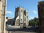 More images |
| Clifton House | King's Lynn | House | 17th century | 1 December 1951 | TF6165319937 52°45′10″N 0°23′38″E / 52.752868°N 0.393786°E / 52.752868; 0.393786 (Clifton House) | 1210377 |  More images |
| Custom House Including North Bank of Purfleet Quay | King's Lynn | Statue | 1683 | 7 June 1972 | TF6162720042 52°45′14″N 0°23′36″E / 52.753819°N 0.393452°E / 52.753819; 0.393452 (Custom House Including North Bank of Purfleet Quay) | 1195414 |  More images |
| Greyfriars Tower in Tower Gardens | King's Lynn | Church tower | c. 1230 | 1 December 1951 | TF6201219787 52°45′05″N 0°23′56″E / 52.751413°N 0.399026°E / 52.751413; 0.399026 (Greyfriars Tower in Tower Gardens) | 1195428 |  More images |
| Guildhall | King's Lynn | Guildhall | 1422-28 | 1 December 1951 | TF6171619861 52°45′08″N 0°23′41″E / 52.752166°N 0.394681°E / 52.752166; 0.394681 (Guildhall) | 1211953 |  More images |
| Guildhall of St George | King's Lynn | Guildhall | 1410-1420 | 1 December 1951 | TF6161820224 52°45′20″N 0°23′36″E / 52.755456°N 0.393409°E / 52.755456; 0.393409 (Guildhall of St George) | 1290960 | 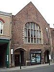 More images |
| Hampton Court | King's Lynn | Merchants House | Early 14th century | 1 December 1951 | TF6173519740 52°45′04″N 0°23′42″E / 52.751074°N 0.394902°E / 52.751074; 0.394902 (Hampton Court) | 1195430 | 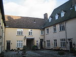 More images |
| Hanse House | King's Lynn | House | Mid 18th century | 1 December 1951 | TF6172719766 52°45′05″N 0°23′41″E / 52.75131°N 0.394797°E / 52.75131; 0.394797 (Hanse House) | 1195393 |  More images |
| Red Mount Chapel | King's Lynn | Chapel | C20 | 1 December 1951 | TF6247019842 52°45′06″N 0°24′21″E / 52.75177°N 0.405832°E / 52.75177; 0.405832 (Red Mount Chapel) | 1195403 |  More images |
| South Gate | King's Lynn | Town Gate | Late 13th century | 1 December 1951 | TF6219919157 52°44′45″N 0°24′05″E / 52.745699°N 0.401483°E / 52.745699; 0.401483 (South Gate) | 1195304 |  More images |
| Thoresby College | King's Lynn | Apartment | 1963-4 | 1 December 1951 | TF6167319849 52°45′07″N 0°23′39″E / 52.752071°N 0.394038°E / 52.752071; 0.394038 (Thoresby College) | 1195418 | 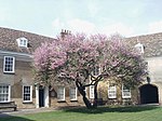 More images |
| 28, 30, 32 King Street | King's Lynn | First Floor Hall House | c. 1180 | 1 December 1951 | TF6165220175 52°45′18″N 0°23′38″E / 52.755006°N 0.393888°E / 52.755006; 0.393888 (28, 30, 32 King Street) | 1195291 | Upload Photo |
Notes
- ^ The date given is the date used by Historic England as significant for the initial building or that of an important part in the structure's description.
- ^ Sometimes known as OSGB36, the grid reference is based on the British national grid reference system used by the Ordnance Survey.
- ^ The "List Entry Number" is a unique number assigned to each listed building and scheduled monument by Historic England.
External links
- v
- t
- e
- Bedfordshire
- Berkshire
- Bristol
- Buckinghamshire
- Cambridgeshire
- Cheshire
- Cornwall
- Cumbria
- Derbyshire
- Devon
- Dorset
- Durham
- East Sussex
- East Riding of Yorkshire
- Essex
- Gloucestershire
- Greater London
- Greater Manchester
- Hampshire
- Herefordshire
- Hertfordshire
- Isle of Wight
- Kent
- Lancashire
- Leicestershire
- Lincolnshire
- Merseyside
- Norfolk
- North Yorkshire
- Northamptonshire
- Northumberland
- Nottinghamshire
- Oxfordshire
- Rutland
- Shropshire
- Somerset
- South Yorkshire
- Staffordshire
- Suffolk
- Surrey
- Tyne and Wear
- Warwickshire
- West Midlands
- West Sussex
- West Yorkshire
- Wiltshire
- Worcestershire
- Babergh
- Bath and North East Somerset
- Bradford
- Brighton and Hove
- Broadland
- Cheltenham
- Cheshire East
- Cheshire West and Chester
- Cotswold
- Craven
- Dartford
- Dover
- Forest Heath
- Forest of Dean
- Ipswich
- Maidstone
- Mendip
- Mid Suffolk
- North Somerset
- Sedgemoor
- South Gloucestershire
- South Somerset
- St Edmundsbury
- Stroud
- Suffolk Coastal
- Taunton Deane
- Tewkesbury
- Waveney
- West Somerset
- Churches
- War memorials
- 20th century


