Grade I listed buildings in South Holland
Map all coordinates using OpenStreetMap
Download coordinates as:
- KML
- GPX (all coordinates)
- GPX (primary coordinates)
- GPX (secondary coordinates)
There are over 9,000 Grade I listed buildings in England. This page is a list of these buildings in the district of South Holland in Lincolnshire.
South Holland
| Name | Location | Type | Completed [note 1] | Date designated | Grid ref.[note 2] Geo-coordinates | Entry number [note 3] | Image |
|---|---|---|---|---|---|---|---|
| Church of St Mary | Cowbit | Parish Church | c. 1380 | 7 February 1967 | TF2597918009 52°44′42″N 0°08′07″W / 52.745031°N 0.13519°W / 52.745031; -0.13519 (Church of St Mary) | 1064482 |  More images |
| Crowland Abbey | Crowland | Abbey | 1155-1999 | 7 February 1967 | TF2415510326 52°40′35″N 0°09′54″W / 52.676421°N 0.165095°W / 52.676421; -0.165095 (Crowland Abbey) | 1064550 | 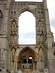 More images |
| Holy Trinity Bridge | Crowland | Footbridge | pre 943 | 1 January 1962 | TF2393910237 52°40′32″N 0°10′06″W / 52.675671°N 0.168321°W / 52.675671; -0.168321 (Holy Trinity Bridge) | 1064508 |  More images |
| Church of St Mary and the Holy Rood | Donington | Church | 1868 | 7 February 1967 | TF2082435943 52°54′26″N 0°12′18″W / 52.907344°N 0.204885°W / 52.907344; -0.204885 (Church of St Mary and the Holy Rood) | 1064449 | 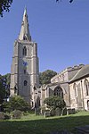 More images |
| Bell Tower | Fleet | Bell Tower | c. 1300 | 7 December 1987 | TF3886823666 52°47′34″N 0°03′29″E / 52.792698°N 0.058015°E / 52.792698; 0.058015 (Bell Tower) | 1064521 |  More images |
| Church of St Mary Magdalen | Fleet | Parish Church | c1180-1190 | 30 June 1966 | TF3888823680 52°47′34″N 0°03′30″E / 52.792819°N 0.058317°E / 52.792819; 0.058317 (Church of St Mary Magdalen) | 1146568 | 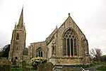 More images |
| Church of St Mary Magdalene | Gedney | Parish Church | 13th century | 30 June 1966 | TF4027824350 52°47′55″N 0°04′45″E / 52.798478°N 0.079204°E / 52.798478; 0.079204 (Church of St Mary Magdalene) | 1359231 |  More images |
| Church of St Peter and St Paul | Gosberton | Parish Church | 12th century | 7 February 1967 | TF2375031759 52°52′09″N 0°09′47″W / 52.869087°N 0.162992°W / 52.869087; -0.162992 (Church of St Peter and St Paul) | 1064425 |  More images |
| Church of All Saints | Holbeach | Parish Church | c1340-80 | 30 June 1966 | TF3591024789 52°48′13″N 0°00′53″E / 52.803539°N 0.014643°E / 52.803539; 0.014643 (Church of All Saints) | 1064486 |  More images |
| Church of St Mary | Long Sutton | Parish Church | Late 12th century | 30 June 1966 | TF4322822874 52°47′04″N 0°07′20″E / 52.784445°N 0.122281°E / 52.784445; 0.122281 (Church of St Mary) | 1064562 |  More images |
| Church of St Nicholas | Lutton | Parish Church | Early 16th century | 30 June 1966 | TF4330725559 52°48′31″N 0°07′29″E / 52.808544°N 0.124627°E / 52.808544; 0.124627 (Church of St Nicholas) | 1359229 | 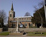 More images |
| Sneaths Mill | Lutton | Windmill | 1779 | 5 October 1976 | TF4358424299 52°47′50″N 0°07′41″E / 52.797151°N 0.12818°E / 52.797151; 0.12818 (Sneaths Mill) | 1064530 |  More images |
| Church of All Saints | Moulton | Parish Church | c. 1180 | 7 February 1967 | TF3071024115 52°47′56″N 0°03′46″W / 52.798768°N 0.062714°W / 52.798768; -0.062714 (Church of All Saints) | 1147325 |  More images |
| Moulton Windmill | Moulton | Tower Mill | c. 1822 | 7 February 1967 | TF3075524035 52°47′53″N 0°03′43″W / 52.798038°N 0.062079°W / 52.798038; -0.062079 (Moulton Windmill) | 1308557 | 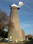 More images |
| Church of St Mary | Pinchbeck | Parish Church | 12th century | 7 February 1967 | TF2419725594 52°48′49″N 0°09′31″W / 52.813593°N 0.158699°W / 52.813593; -0.158699 (Church of St Mary) | 1064433 |  More images |
| Church of St Margaret | Quadring | Parish Church | 14th century | 7 February 1967 | TF2242434101 52°53′26″N 0°10′54″W / 52.890433°N 0.1818°W / 52.890433; -0.1818 (Church of St Margaret) | 1147013 |  More images |
| Church of St Lawrence | Surfleet | Parish Church | 13th century | 7 February 1967 | TF2513628230 52°50′13″N 0°08′38″W / 52.83706°N 0.143766°W / 52.83706; -0.143766 (Church of St Lawrence) | 1064403 | 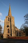 More images |
| Church of St Mary | Tydd St. Mary | Parish Church | 12th century | 30 June 1966 | TF4461118591 52°44′44″N 0°08′27″E / 52.745601°N 0.140883°E / 52.745601; 0.140883 (Church of St Mary) | 1204871 | 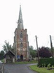 More images |
| Church of St Mary | Weston | Church | c. 1170 | 7 February 1967 | TF2924825153 52°48′30″N 0°05′02″W / 52.808445°N 0.083976°W / 52.808445; -0.083976 (Church of St Mary) | 1064475 |  More images |
| The Wykeham Chapel of St Nicholas | Weston | Chapel | Late 19th century | 7 February 1967 | TF2763526433 52°49′13″N 0°06′27″W / 52.820329°N 0.107391°W / 52.820329; -0.107391 (The Wykeham Chapel of St Nicholas) | 1064471 | 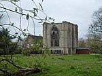 More images |
| Church of St Mary | Whaplode | Parish Church | c. 1150 | 30 June 1966 | TF3235124013 52°47′51″N 0°02′18″W / 52.797452°N 0.038431°W / 52.797452; -0.038431 (Church of St Mary) | 1359295 | 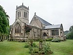 More images |
| Ayscoughfee Hall | Spalding | Open Hall House | Mid 15th century | 29 December 1950 | TF2491322362 52°47′04″N 0°08′58″W / 52.784389°N 0.149315°W / 52.784389; -0.149315 (Ayscoughfee Hall) | 1359532 |  More images |
| Church of St Paul including attached former Sunday Schoolroom | Fulney, Spalding | Church | 1877-80 | 20 November 1975 | TF2614423802 52°47′49″N 0°07′50″W / 52.797041°N 0.130519°W / 52.797041; -0.130519 (Church of St Paul including attached former Sunday Schoolroom) | 1306702 |  More images |
| Parish Church of St Mary and St Nicolas | Spalding | Parish Church | 1284 | 29 December 1950 | TF2502422415 52°47′05″N 0°08′52″W / 52.78484°N 0.14765°W / 52.78484; -0.14765 (Parish Church of St Mary and St Nicolas) | 1359547 |  More images |
| Spalding War Memorial | Spalding | war memorial | 1922 | 20 November 1975 | TF2491722256 52°47′03″N 0°09′01″W / 52.7840792°N 0.1501686°W / 52.7840792; -0.1501686 (Spalding War Memorial) | 1064002 |  More images |
Notes
- ^ The date given is the date used by Historic England as significant for the initial building or that of an important part in the structure's description.
- ^ Sometimes known as OSGB36, the grid reference is based on the British national grid reference system used by the Ordnance Survey.
- ^ The "List Entry Number" is a unique number assigned to each listed building and scheduled monument by Historic England.
External links
- v
- t
- e
- Bedfordshire
- Berkshire
- Bristol
- Buckinghamshire
- Cambridgeshire
- Cheshire
- Cornwall
- Cumbria
- Derbyshire
- Devon
- Dorset
- Durham
- East Sussex
- East Riding of Yorkshire
- Essex
- Gloucestershire
- Greater London
- Greater Manchester
- Hampshire
- Herefordshire
- Hertfordshire
- Isle of Wight
- Kent
- Lancashire
- Leicestershire
- Lincolnshire
- Merseyside
- Norfolk
- North Yorkshire
- Northamptonshire
- Northumberland
- Nottinghamshire
- Oxfordshire
- Rutland
- Shropshire
- Somerset
- South Yorkshire
- Staffordshire
- Suffolk
- Surrey
- Tyne and Wear
- Warwickshire
- West Midlands
- West Sussex
- West Yorkshire
- Wiltshire
- Worcestershire
- Babergh
- Bath and North East Somerset
- Bradford
- Brighton and Hove
- Broadland
- Cheltenham
- Cheshire East
- Cheshire West and Chester
- Cotswold
- Craven
- Dartford
- Dover
- Forest Heath
- Forest of Dean
- Ipswich
- Maidstone
- Mendip
- Mid Suffolk
- North Somerset
- Sedgemoor
- South Gloucestershire
- South Somerset
- St Edmundsbury
- Stroud
- Suffolk Coastal
- Taunton Deane
- Tewkesbury
- Waveney
- West Somerset
- Churches
- War memorials
- 20th century


