Mukim Kuala Belait
Mukim of Brunei
Mukim in Belait, Brunei
Mukim Kuala Belait | |
|---|---|
Mukim | |
    Clockwise from top left: Mukim Kuala Belait sign, Sungai Tujoh checkpoint, Sungai Teraban, Kuala Belait Town | |
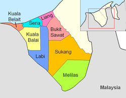 Kuala Belait is in red. | |
| Coordinates: 4°35′N 114°11′E / 4.583°N 114.183°E / 4.583; 114.183 | |
| Country | Brunei |
| District | Belait |
| Government | |
| • Penghulu | Abdul Afiq Zainuddin[1] |
| Population (2021)[2] | |
| • Total | 28,793 |
| Time zone | UTC+8 (BNT) |
| Postcode | KAxx31 |
Mukim Kuala Belait is a mukim in Belait District, Brunei.[3] The population was 31,308 in 2016.[4] The mukim encompasses Kuala Belait, the administrative town of the district.
Geography
The mukim is the located in the westernmost part of the district as well as the country. It borders the South China Sea to the north, Mukim Seria to the east, Mukim Kuala Balai to the south-east and the Malaysian state of Sarawak to the south and west.[citation needed]
The primary settlements encompassed by the mukim include Kuala Belait town, Kampong Pandan, Kampong Sungai Teraban and Mumong.
Demographics
As of 2016 census,[4] the population was 31,308 with 53.6% males and 46.4% females. The mukim had 5,819 households occupying 5,659 dwellings. The entire population lived in urban areas.
Administration
As of 2021, the mukim comprised the following villages:
| Settlements[2] | Population (2021)[2] | Ketua kampung (2024)[1][5] |
|---|---|---|
| Kuala Belait Town Area 'A' | 4,544 | Muhammad Sufrizal bin Haji Hamdan (Acting) |
| Kuala Belait Town Area 'B' | Muhammad Sufrizal bin Haji Hamdan | |
| Kampong Pandan 'A' | 4,983 | Abdul Aziz bin Haji Seri |
| Kampong Pandan 'B' | 3,859 | Muhammad Rawinyani bin Morney |
| Kampong Pandan 'C' | 5,769 | Haji Affandy bin Haji Awang Damit |
| Kampong Mumong 'B' | 3,141 | Haji Mohd Yusof bin Haji Dulamin (Acting) |
| Kampong Mumong 'A' | 5,523 | Haji Mohd Yusof bin Haji Dulamin |
| Kampong Sungai Teraban | 974 | Zaini bin Haji Kaderi |
Infrastructures
Public housing
There are two public housing estates in the mukim, namely RPN Kampong Pandan and STKRJ Mumong.
Other locations
Other locations within the mukim include:
- Sungai Tujoh - the location of the customs/immigration point at the border with Sarawak, Malaysia
- Rasau - gas field operated by Brunei Shell Petroleum
- The mouth of the Belait River, the longest river in Brunei
- Istana Kota Manggalela, the residence of Sultan Hassanal Bolkiah in Kuala Belait
References
- ^ a b BUKU DIREKTORI TELEFON PENGHULU-PENGHULU MUKIM DAN KETUA-KETUA KAMPUNG NEGARA BRUNEI DARUSSALAM (PDF) (in Malay). Vol. 4. Brunei: Bahagian Perancangan Daerah, Ministry of Home Affairs. April 2024. p. 20.
- ^ a b c "Annex B" (PDF). DEPS.MoFE.gov.bn. Department of Economic Planning and Statistics, Ministry of Finance and Economy. October 2021. Retrieved 23 January 2024.
- ^ "Belait District" (PDF). www.information.gov.bn. 2011. pp. 8–9. Retrieved 28 June 2021.
- ^ a b "Population and Housing Census Update Final Report 2016" (PDF). www.deps.gov.bn. Statistics Department. December 2018. Retrieved 27 June 2021.
- ^ "Direktori Penghulu, Ketua Kampung, dan Ketua Rumah Panjang". Jabatan Daerah Belait (in Malay). Retrieved 2024-08-20.
- v
- t
- e
- Bukit Sawat
- Kuala Balai
- Kuala Belait
- Labi
- Liang
- Melilas
- Seria
- Sukang

 | This Brunei location article is a stub. You can help Wikipedia by expanding it. |
- v
- t
- e


