Mukim Liang
Mukim of Brunei
Mukim in Belait, Brunei
Mukim Liang | |
|---|---|
Mukim | |
    Clockwise from top left: Lumut, Brunei Fertilizer Industries, Zainab Mosque, Sungai Gana | |
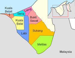 Liang is in pink. | |
| Coordinates: 4°39′36″N 114°27′32″E / 4.66000°N 114.45889°E / 4.66000; 114.45889 | |
| Country | Brunei |
| District | Belait |
| Government | |
| • Penghulu | Yamin Abdul Ranni[1] |
| Population (2021)[2] | |
| • Total | 16,813 |
| Time zone | UTC+8 (BNT) |
| Postcode | KCxx35 |
Mukim Liang is a mukim in Belait District, Brunei.[3] The population was 14,301 in 2016.[4]
Geography
The mukim is located in the north of the district, bordering the South China Sea to the north, Mukim Telisai in Tutong District to the north-east, Mukim Bukit Sawat to the south-east, Mukim Labi to the south and Mukim Seria to the west.[5]
Demographics
As of 2016 census,[4] the population was 14,301 with 51.4% males and 48.6% females. The mukim had 2,607 households occupying 2,602 dwellings. Among the population, 32.3% lived in urban areas, while the remainder of 67.7% lived in rural areas.
Administration
As of 2021, the mukim comprised the following villages:
| Settlements[2] | Population (2021)[2] | Ketua kampung (2024)[1][6] |
|---|---|---|
| Kampong Sungai Tali | 1,051 | Haji Khairdon bin Haji Dahlan |
| Kampong Sungai Taring | 857 | |
| Kampong Sungai Bakong | 1,642 | Taib bin Haji Salleh |
| Kampong Sungai Kuru | 495 | |
| Kampong Lumut | 171 | |
| Kampong Lumut Camp | 864 | — |
| RPN Kampong Lumut Area 1 | 2,035 | Saini bin Ismail |
| RPN Kampong Lumut Area 2 | 5,605 | Salleh bin Haji Bujang |
| Kampong Lumut Tersusun | 1,205 | Taib bin Haji Salleh |
| Kampong Sungai Kang | 56 | |
| Kampong Sungai Lalit | 397 | |
| Kampong Agis-Agis | 217 | |
| Kampong Perumpong | 427 | — |
| Kampong Sungai Liang | 641 | Mohammad Haszrin bin Bagol |
| Kampong Tunggulian | 656 | — |
| Kampong Lilas | 148 | |
| Kampong Sungai Gana | 160 | |
| Kampong Keluyoh | 186 |
References
- ^ a b BUKU DIREKTORI TELEFON PENGHULU-PENGHULU MUKIM DAN KETUA-KETUA KAMPUNG NEGARA BRUNEI DARUSSALAM (PDF) (in Malay). Vol. 4. Brunei: Bahagian Perancangan Daerah, Ministry of Home Affairs. April 2024. p. 22.
- ^ a b c "Annex B" (PDF). DEPS.MoFE.gov.bn. Department of Economic Planning and Statistics, Ministry of Finance and Economy. October 2021. Retrieved 23 January 2024.
- ^ "Belait District" (PDF). www.information.gov.bn. 2011. pp. 8–9. Retrieved 28 June 2021.
- ^ a b "Population and Housing Census Update Final Report 2016" (PDF). www.deps.gov.bn. Statistics Department. December 2018. Retrieved 27 June 2021.
- ^ Brunei Darussalam street directory : quick & easy reference maps., Brunei. Juruukur Agung., Brunei Press Sdn. Bhd., Published & printed by Brunei Press Sdn. Bhd., Commercial Printing Services, 2014, ISBN 9789991732411, OCLC 932264901
{{citation}}: CS1 maint: others (link) - ^ "Direktori Penghulu, Ketua Kampung, dan Ketua Rumah Panjang". Jabatan Daerah Belait (in Malay). Retrieved 20 August 2024.

 | This Brunei location article is a stub. You can help Wikipedia by expanding it. |
- v
- t
- e


