National Register of Historic Places listings in Catahoula Parish, Louisiana

This is a list of the National Register of Historic Places listings in Catahoula Parish, Louisiana.
This is intended to be a complete list of the properties on the National Register of Historic Places in Catahoula Parish, Louisiana, United States. The locations of National Register properties for which the latitude and longitude coordinates are included below, may be seen in a map.[1]
There are 14 properties listed on the National Register in the parish.
This National Park Service list is complete through NPS recent listings posted July 12, 2024.[2]
Map all coordinates using OpenStreetMap
Download coordinates as:
- KML
- GPX (all coordinates)
- GPX (primary coordinates)
- GPX (secondary coordinates)
Current listings
| [3] | Name on the Register | Image | Date listed[4] | Location | City or town | Description |
|---|---|---|---|---|---|---|
| 1 | Battleground Plantation | Upload image | May 14, 1979 (#79001056) | About 1 mile (1.6 km) southeast of LA 15 and about 3.2 miles (5.1 km) north of Sicily Island 31°53′33″N 91°38′46″W / 31.89241°N 91.64612°W / 31.89241; -91.64612 (Battleground Plantation) | Sicily Island vicinity | |
| 2 | Caney Mounds | Upload image | September 6, 2005 (#05000986) | Address restricted[5] | Jonesville | |
| 3 | Catahoula Parish Courthouse | 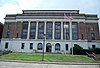 | October 27, 1988 (#88002056) | 301 Bushley Street (LA 124) 31°46′18″N 91°49′17″W / 31.77176°N 91.8214°W / 31.77176; -91.8214 (Catahoula Parish Courthouse) | Harrisonburg | |
| 4 | Ferry Place |  | August 29, 1980 (#80001711) | Address restricted[5] | Sicily Island | |
| 5 | Green-Lovelace House | Upload image | April 5, 1983 (#83000495) | About 300 yards (270 m) east of LA 15 and about 2 miles (3.2 km) north of Sicily Island 31°52′30″N 91°39′35″W / 31.87497°N 91.65977°W / 31.87497; -91.65977 (Green-Lovelace House) | Sicily Island vicinity | |
| 6 | Hardin House | Upload image | November 8, 1990 (#90001740) | Along LA 913, about 900 yards (820 m) north of its junction with LA 8 31°50′06″N 91°43′07″W / 31.8351°N 91.71856°W / 31.8351; -91.71856 (Hardin House) | Sicily Island | Also known as Harts' Crossing. |
| 7 | Harrisonburg Methodist Church | Upload image | June 15, 2015 (#15000345) | 105 Pine Street 31°46′15″N 91°49′16″W / 31.77092°N 91.82109°W / 31.77092; -91.82109 (Harrisonburg Methodist Church) | Harrisonburg | |
| 8 | Kirby House | Upload image | January 21, 1988 (#87002498) | Corner of Trinity Road and Trinity Road B 31°37′54″N 91°48′44″W / 31.63155°N 91.81224°W / 31.63155; -91.81224 (Kirby House) | Trinity | |
| 9 | Marengo Plantation House |  | December 14, 1987 (#87002135) | North of US 84, about 6.5 miles (10.5 km) west of Jonesville 31°35′30″N 91°55′21″W / 31.591767°N 91.922613°W / 31.591767; -91.922613 (Marengo Plantation House) | Jonesville vicinity | |
| 10 | Moss Grove Plantation House | Upload image | September 6, 2006 (#06000779) | 509 Black River Road 31°32′50″N 91°48′08″W / 31.54728°N 91.80222°W / 31.54728; -91.80222 (Moss Grove Plantation House) | Jonesville | |
| 11 | Paul's Camp South | Upload image | May 26, 2004 (#04000529) | Address restricted[5] | Jonesville | |
| 12 | Sargent House | Upload image | December 3, 1980 (#80001710) | 103 Catahoula Street 31°46′20″N 91°49′11″W / 31.77221°N 91.81968°W / 31.77221; -91.81968 (Sargent House) | Harrisonburg | |
| 13 | Spring Ridge Baptist Church | 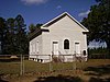 | October 7, 1993 (#93001037) | Along Springridge Road, about 6.5 miles (10.5 km) southwest of Enterprise and about 4 miles (6.4 km) north of Aimwell 31°50′02″N 91°57′57″W / 31.83401°N 91.96591°W / 31.83401; -91.96591 (Spring Ridge Baptist Church) | Aimwell | |
| 14 | Wildwood | Upload image | October 30, 1989 (#89001874) | On the levee of Tensas River, about 0.75 miles (1.21 km) east of LA 15 and about 5.3 miles (8.5 km) southeast of Sicily Island 31°48′43″N 91°34′34″W / 31.81202°N 91.57614°W / 31.81202; -91.57614 (Wildwood) | Sicily Island |
See also
Wikimedia Commons has media related to National Register of Historic Places in Catahoula Parish, Louisiana.
- List of National Historic Landmarks in Louisiana
- National Register of Historic Places listings in Louisiana
References
- ^ The latitude and longitude information provided in this table was derived originally from the National Register Information System, which has been found to be fairly accurate for about 99% of listings. Some locations in this table may have been corrected to current GPS standards.
- ^ National Park Service, United States Department of the Interior, "National Register of Historic Places: Weekly List Actions", retrieved July 12, 2024.
- ^ Numbers represent an alphabetical ordering by significant words. Various colorings, defined here, differentiate National Historic Landmarks and historic districts from other NRHP buildings, structures, sites or objects.
- ^ The eight-digit number below each date is the number assigned to each location in the National Register Information System database, which can be viewed by clicking the number.
- ^ a b c Federal and state laws and practices restrict general public access to information regarding the specific location of this resource. In some cases, this is to protect archeological sites from vandalism, while in other cases it is restricted at the request of the owner. See: Knoerl, John; Miller, Diane; Shrimpton, Rebecca H. (1990), Guidelines for Restricting Information about Historic and Prehistoric Resources, National Register Bulletin, National Park Service, U.S. Department of the Interior, OCLC 20706997.
- v
- t
- e
by parish
- Acadia
- Allen
- Ascension
- Assumption
- Avoyelles
- Beauregard
- Bienville
- Bossier
- Caddo
- Calcasieu
- Caldwell
- Cameron
- Catahoula
- Claiborne
- Concordia
- DeSoto
- East Baton Rouge
- East Carroll
- East Feliciana
- Evangeline
- Franklin
- Grant
- Iberia
- Iberville
- Jackson
- Jefferson
- Jefferson Davis
- La Salle
- Lafayette
- Lafourche
- Lincoln
- Livingston
- Madison
- Morehouse
- Natchitoches
- Orleans
- Ouachita
- Plaquemines
- Pointe Coupee
- Rapides
- Red River
- Richland
- Sabine
- St. Bernard
- St. Charles
- St. Helena
- St. James
- St. John the Baptist
- St. Landry
- St. Martin
- St. Mary
- St. Tammany
- Tangipahoa
- Tensas
- Terrebonne
- Union
- Vermilion
- Vernon
- Washington
- Webster
- West Baton Rouge
- West Carroll
- West Feliciana
- Winn

Municipalities and communities of Catahoula Parish, Louisiana, United States | ||
|---|---|---|
Parish seat: Harrisonburg | ||
| Town |  | |
| Villages | ||
| CDP | ||
| Other unincorporated communities | ||
| Footnotes | ‡This populated place also has portions in an adjacent parish or parishes | |
| ||


