National Register of Historic Places listings in Jefferson Parish, Louisiana

This is a list of the National Register of Historic Places listings in Jefferson Parish, Louisiana.
This is intended to be a complete list of the properties and districts on the National Register of Historic Places in Jefferson Parish, Louisiana, United States. The locations of National Register properties and districts for which the latitude and longitude coordinates are included below, may be seen in a map.[1]
There are 24 properties and districts listed on the National Register in the parish, and one former listing.
This National Park Service list is complete through NPS recent listings posted July 12, 2024.[2]
Map all coordinates using OpenStreetMap
Download coordinates as:
- KML
- GPX (all coordinates)
- GPX (primary coordinates)
- GPX (secondary coordinates)
Current listings
| [3] | Name on the Register[4] | Image | Date listed[5] | Location | City or town | Description |
|---|---|---|---|---|---|---|
| 1 | Barataria Unit of Jean Lafitte Historical Park Historic District |  | October 15, 1966 (#66000966) | 6588 Barataria Boulevard 29°47′56″N 90°07′24″W / 29.79882°N 90.12341°W / 29.79882; -90.12341 (Barataria Unit of Jean Lafitte Historical Park Historic District) | Marrero vicinity | The 1,855 acres (751 ha) area Nature Preserve is roughly bounded by Bayou Coquilles, Bayou des Familles, Bayou Barataria, Bayou Villars, and Lake Salvador. |
| 2 | L.J. Bernard Hardware Store |  | September 22, 2000 (#00001144) | 275 Sala Avenue 29°54′50″N 90°08′36″W / 29.91398°N 90.14341°W / 29.91398; -90.14341 (L.J. Bernard Hardware Store) | Westwego | Now hosting the Westwego Historical Museum.[6] |
| 3 | Conrad A. Buchler House |  | September 9, 1999 (#99001114) | 236 Sala Avenue 29°54′53″N 90°08′36″W / 29.91475°N 90.14338°W / 29.91475; -90.14338 (Conrad A. Buchler House) | Westwego | |
| 4 | Camp Parapet Powder Magazine |  | May 24, 1977 (#77000671) | 2812 Arlington Street 29°57′40″N 90°09′20″W / 29.96116°N 90.1556°W / 29.96116; -90.1556 (Camp Parapet Powder Magazine) | Jefferson | Civil War fortification |
| 5 | David Crockett Fire Hall and Pumper |  | January 27, 1983 (#83000510) | 205 Lafayette Street 29°55′08″N 90°03′47″W / 29.91875°N 90.06297°W / 29.91875; -90.06297 (David Crockett Fire Hall and Pumper) | Gretna | Historic firehouse, now part of Gretna Historical Society Museum.[7] Also part of Gretna Historic District since its creation on May 2, 1985.[8] |
| 6 | Felix-Block Building |  | July 18, 1985 (#85001587) | 303 Williams Boulevard 29°58′24″N 90°14′49″W / 29.97346°N 90.24681°W / 29.97346; -90.24681 (Felix-Block Building) | Kenner | Now hosting the Kenner Heritage Hall. |
| 7 | Fort Livingston |  | August 30, 1974 (#74000925) | Western end of Grande Terre Island 29°16′23″N 89°56′43″W / 29.27304°N 89.94516°W / 29.27304; -89.94516 (Fort Livingston) | Grand Isle vicinity | Ruins of early 19th century fort |
| 8 | Gretna Historic District |  | May 2, 1985 (#85000954) | Roughly bounded by 1st Street, Amelia Street, 9th Street, Gulf Drive, 4th Street and Huey P. Long Avenue 29°54′56″N 90°03′47″W / 29.91546°N 90.06309°W / 29.91546; -90.06309 (Gretna Historic District) | Gretna | |
| 9 | Harahan Elementary School |  | April 14, 1983 (#83000511) | 6723 Jefferson Highway 29°56′16″N 90°11′47″W / 29.93788°N 90.1964°W / 29.93788; -90.1964 (Harahan Elementary School) | Harahan | |
| 10 | Humble Oil Camp Historic District | Upload image | April 15, 2020 (#100005188) | 101-143 Marlin Ln. 29°14′41″N 89°58′43″W / 29.2448°N 89.9786°W / 29.2448; -89.9786 (Humble Oil Camp Historic District) | Grand Isle | |
| 11 | Kenner Town Hall |  | January 23, 1986 (#86000112) | 1903 Short Street 29°58′31″N 90°14′53″W / 29.97537°N 90.24815°W / 29.97537; -90.24815 (Kenner Town Hall) | Kenner | |
| 12 | Kerner House |  | January 28, 2000 (#00000008) | 1012 Monroe Street 29°55′44″N 90°03′03″W / 29.92897°N 90.05092°W / 29.92897; -90.05092 (Kerner House) | Gretna | |
| 13 | Kirby-Adam House | Upload image | December 4, 2018 (#100003192) | 142B Community Ln. 29°14′15″N 89°59′47″W / 29.2374°N 89.9963°W / 29.2374; -89.9963 (Kirby-Adam House) | Grand Isle | |
| 14 | Magnolia Lane Plantation House |  | February 13, 1986 (#86000253) | Along River Road (LA 541) at Nine Mile Point 29°56′59″N 90°09′12″W / 29.94986°N 90.1533°W / 29.94986; -90.1533 (Magnolia Lane Plantation House) | Westwego vicinity | Plantation house at Nine Mile Point; originally Fortier Plantation |
| 15 | Ed Martin Seafood Company Factory and House |  | September 29, 2000 (#00001170) | 300 and 306 Sala Avenue 29°54′50″N 90°08′38″W / 29.91388°N 90.14392°W / 29.91388; -90.14392 (Ed Martin Seafood Company Factory and House) | Westwego | |
| 16 | McDonoghville Historic District | Upload image | July 26, 2022 (#100007945) | Roughly bounded by the Crescent City Connection, Jefferson Parish Line, Hancock St., 4th St. extension, Ocean Ave., and the Mississippi R. Trail 29°55′43″N 90°03′09″W / 29.9287°N 90.0524°W / 29.9287; -90.0524 (McDonoghville Historic District) | Gretna | |
| 17 | Old Jefferson Parish Courthouse |  | January 21, 1983 (#83000512) | 740 2nd Street 29°55′01″N 90°03′56″W / 29.91693°N 90.06569°W / 29.91693; -90.06569 (Old Jefferson Parish Courthouse) | Gretna | Now hosting the Gretna City Hall. Also part of Gretna Historic District since its creation on May 2, 1985.[8] |
| 18 | Vic Pitre House |  | August 20, 1998 (#98001080) | 476 Sala Avenue 29°54′40″N 90°08′44″W / 29.91117°N 90.14543°W / 29.91117; -90.14543 (Vic Pitre House) | Westwego | |
| 19 | Poche House | Upload image | December 4, 2018 (#100003193) | 102 Community Ln. 29°14′14″N 89°59′46″W / 29.2371°N 89.9961°W / 29.2371; -89.9961 (Poche House) | Grand Isle | |
| 20 | Raziano House |  | August 14, 1998 (#98001058) | 913 Minor Street 29°58′54″N 90°14′45″W / 29.98179°N 90.24586°W / 29.98179; -90.24586 (Raziano House) | Kenner | |
| 21 | Robin House | Upload image | December 4, 2018 (#100003194) | 176 Coulon Riguard Rd. 29°14′03″N 89°59′51″W / 29.2343°N 89.9976°W / 29.2343; -89.9976 (Robin House) | Grand Isle | |
| 22 | St. Joseph Church-Convent of the Most Holy Sacrament Complex |  | April 15, 1983 (#83000513) | Corner of Lavoisier Street and 7th Street 29°54′52″N 90°03′40″W / 29.91435°N 90.06118°W / 29.91435; -90.06118 (St. Joseph Church-Convent of the Most Holy Sacrament Complex) | Gretna | Also part of Gretna Historic District since its creation on May 2, 1985.[8] |
| 23 | United States Coast Guard Station No. 79 | Upload image | December 4, 2018 (#100003195) | 170 Ludwig Ln. 29°14′02″N 89°59′53″W / 29.2338°N 89.9981°W / 29.2338; -89.9981 (United States Coast Guard Station No. 79) | Grand Isle | |
| 24 | Valence House | Upload image | March 23, 2023 (#100008740) | 205 Cemetery Ln. 29°14′11″N 89°59′27″W / 29.2364°N 89.9908°W / 29.2364; -89.9908 (Valence House) | Grand Isle |
Former listings
| [3] | Name on the Register | Image | Date listed | Date removed | Location | City or town | Description |
|---|---|---|---|---|---|---|---|
| 1 | Old Kenner High School | 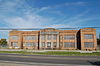 | February 7, 2008 (#08000014) | March 19, 2024 | 1601 Reverend Richard Wilson Drive 29°58′30″N 90°15′09″W / 29.97488°N 90.25247°W / 29.97488; -90.25247 (Old Kenner High School) | Kenner | Building heavily damaged by fire on February 19, 2018.[9][10] |
See also
Wikimedia Commons has media related to National Register of Historic Places in Jefferson Parish, Louisiana.
- List of National Historic Landmarks in Louisiana
- National Register of Historic Places listings in Louisiana
References
- ^ The latitude and longitude information provided in this table was derived originally from the National Register Information System, which has been found to be fairly accurate for about 99% of listings. Some locations in this table may have been corrected to current GPS standards.
- ^ National Park Service, United States Department of the Interior, "National Register of Historic Places: Weekly List Actions", retrieved July 12, 2024.
- ^ a b Numbers represent an alphabetical ordering by significant words. Various colorings, defined here, differentiate National Historic Landmarks and historic districts from other NRHP buildings, structures, sites or objects.
- ^ "National Register Information System". National Register of Historic Places. National Park Service. March 13, 2009.
- ^ The eight-digit number below each date is the number assigned to each location in the National Register Information System database, which can be viewed by clicking the number.
- ^ Westwego Historical Museum on Visit Jefferson Parish webpage
- ^ Gretna Historical Society Museum page at louisianatravel.com
- ^ a b c "Gretna Historic District" (PDF). State of Louisiana's Division of Historic Preservation. Archived from the original (PDF) on June 27, 2018. Retrieved June 27, 2018.
- ^ Carlie Kollath Wells (February 19, 2018). "Old Kenner High School heavily damaged by fire: officials". nola.com. The Times-Picayune. Retrieved June 28, 2018.
- ^ "Fire damages historic old Kenner High School". fox8live.com. Fox 8. Retrieved June 28, 2018.
- v
- t
- e
by parish
- Acadia
- Allen
- Ascension
- Assumption
- Avoyelles
- Beauregard
- Bienville
- Bossier
- Caddo
- Calcasieu
- Caldwell
- Cameron
- Catahoula
- Claiborne
- Concordia
- DeSoto
- East Baton Rouge
- East Carroll
- East Feliciana
- Evangeline
- Franklin
- Grant
- Iberia
- Iberville
- Jackson
- Jefferson
- Jefferson Davis
- La Salle
- Lafayette
- Lafourche
- Lincoln
- Livingston
- Madison
- Morehouse
- Natchitoches
- Orleans
- Ouachita
- Plaquemines
- Pointe Coupee
- Rapides
- Red River
- Richland
- Sabine
- St. Bernard
- St. Charles
- St. Helena
- St. James
- St. John the Baptist
- St. Landry
- St. Martin
- St. Mary
- St. Tammany
- Tangipahoa
- Tensas
- Terrebonne
- Union
- Vermilion
- Vernon
- Washington
- Webster
- West Baton Rouge
- West Carroll
- West Feliciana
- Winn


