National Register of Historic Places listings in Klamath County, Oregon

This list presents the full set of buildings, structures, objects, sites, or districts designated on the National Register of Historic Places in Klamath County, Oregon, and offers brief descriptive information about each of them. The National Register recognizes places of national, state, or local historic significance across the United States.[1] Out of over 90,000 National Register sites nationwide,[2] Oregon is home to over 2,000,[3] and 30 of those are found partially or wholly in Klamath County.
This National Park Service list is complete through NPS recent listings posted August 16, 2024.[4]
Current listings
| [5] | Name on the Register | Image | Date listed[6] | Location | City or town | Description |
|---|---|---|---|---|---|---|
| 1 | Army Corps of Engineers Road System |  | August 12, 2019 (#100004255) | Roughly parallel to Rim Drive and Pinnacles Road 42°52′48″N 122°02′16″W / 42.879913°N 122.037883°W / 42.879913; -122.037883 (Army Corps of Engineers Road System) | Crater Lake National Park | |
| 2 | Baldwin Hotel |  | October 2, 1973 (#73001576) | 31 Main St. 42°13′14″N 121°47′12″W / 42.220556°N 121.786667°W / 42.220556; -121.786667 (Baldwin Hotel) | Klamath Falls | |
| 3 | Judge Henry L. Benson House | 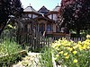 | December 2, 1981 (#81000496) | 137 High St. 42°13′25″N 121°47′07″W / 42.223611°N 121.785278°W / 42.223611; -121.785278 (Judge Henry L. Benson House) | Klamath Falls | |
| 4 | Bisbee Hotel |  | October 12, 2006 (#06000938) | 229 S. 6th St. 42°13′27″N 121°46′47″W / 42.224167°N 121.779722°W / 42.224167; -121.779722 (Bisbee Hotel) | Klamath Falls | |
| 5 | Blackburn Sanitarium |  | September 27, 1996 (#96001046) | 1842 Esplanade Avenue 42°13′58″N 121°46′25″W / 42.232767°N 121.773543°W / 42.232767; -121.773543 (Blackburn Sanitarium) | Klamath Falls | |
| 6 | Bly Ranger Station |  | March 11, 1981 (#81000650) | Highway 140 42°24′03″N 121°02′41″W / 42.400833°N 121.044722°W / 42.400833; -121.044722 (Bly Ranger Station) | Bly | |
| 7 | Comfort Station No. 68 |  | December 1, 1988 (#88002624) | Rim Dr., near Rim Village Campground 42°54′42″N 122°08′44″W / 42.911667°N 122.145556°W / 42.911667; -122.145556 (Comfort Station No. 68) | Crater Lake National Park | |
| 8 | Comfort Station No. 72 |  | December 1, 1988 (#88002625) | Rim Dr., in Rim Village Campground 42°54′41″N 122°08′50″W / 42.911318°N 122.147270°W / 42.911318; -122.147270 (Comfort Station No. 72) | Crater Lake National Park | |
| 9 | Crater Lake Lodge |  | May 5, 1981 (#81000096) | Crater Lake National Park 42°54′36″N 122°08′22″W / 42.91°N 122.139444°W / 42.91; -122.139444 (Crater Lake Lodge) | Crater Lake National Park | |
| 10 | Crater Lake Superintendent's Residence |  | May 28, 1987 (#87001347) | Munson Valley 42°54′03″N 122°08′12″W / 42.900833°N 122.136667°W / 42.900833; -122.136667 (Crater Lake Superintendent's Residence) | Crater Lake National Park | The 1930s-era Munson Valley development was originally one of the best-designed rustic installations in a U.S. national park. This is the only building in the group to remain in near-original condition, and it employed unusual construction methods in response to the very short Crater Lake building season.[7] |
| 11 | Fort Klamath Site |  | October 7, 1971 (#71000680) | SE of Fort Klamath 42°41′31″N 121°58′20″W / 42.691944°N 121.972222°W / 42.691944; -121.972222 (Fort Klamath Site) | Fort Klamath | |
| 12 | Fred Goeller House |  | June 3, 1998 (#98000624) | 234 Riverside Dr. 42°13′03″N 121°47′29″W / 42.217479°N 121.791391°W / 42.217479; -121.791391 (Fred Goeller House) | Klamath Falls | As of 2013, the Goeller House has fallen into a state of disrepair.[8] |
| 13 | Honeymoon Creek Snow-Survey Cabin |  | December 29, 2000 (#00000515) | Sky Lakes Wilderness 42°40′01″N 122°11′54″W / 42.666991°N 122.198452°W / 42.666991; -122.198452 (Honeymoon Creek Snow-Survey Cabin) | Ashland vicinity | |
| 14 | Jacksonville-to-Fort Klamath Military Wagon Road |  | May 16, 1979 (#79002068) | S of Butte Falls 42°28′46″N 122°26′57″W / 42.479444°N 122.449167°W / 42.479444; -122.449167 (Jacksonville-to-Fort Klamath Military Wagon Road) | Butte Falls vicinity | |
| 15 | Klamath County Armory and Auditorium | 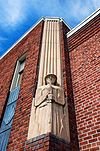 | May 18, 2011 (#11000295) | 1451 Main St. 42°13′42″N 121°46′29″W / 42.228333°N 121.774722°W / 42.228333; -121.774722 (Klamath County Armory and Auditorium) | Klamath Falls | |
| 16 | Klamath Falls City Hall |  | October 30, 1989 (#89001861) | 226 S. 5th St. 42°13′24″N 121°46′51″W / 42.223333°N 121.780833°W / 42.223333; -121.780833 (Klamath Falls City Hall) | Klamath Falls | |
| 17 | Old Klamath Falls City Library |  | October 30, 1989 (#89001863) | 500 Klamath Ave. 42°13′25″N 121°46′51″W / 42.223611°N 121.780833°W / 42.223611; -121.780833 (Old Klamath Falls City Library) | Klamath Falls | |
| 18 | Lake of the Woods Ranger Station – Work Center | 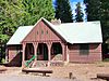 | April 8, 1986 (#86000845) | Winema National Forest 42°23′09″N 122°13′34″W / 42.385833°N 122.226111°W / 42.385833; -122.226111 (Lake of the Woods Ranger Station – Work Center) | Klamath Falls vicinity | |
| 19 | Linkville Pioneer Cemetery |  | July 11, 2014 (#14000400) | Corner of Lexington Avenue and Upham Street 42°14′02″N 121°46′58″W / 42.233828°N 121.782668°W / 42.233828; -121.782668 (Linkville Pioneer Cemetery) | Klamath Falls | |
| 20 | Lower Klamath National Wildlife Refuge |  | October 15, 1966 (#66000238) | Lower Klamath Lake, east of Dorris, California (See also Siskiyou County, California.) 41°56′48″N 121°39′53″W / 41.946667°N 121.664722°W / 41.946667; -121.664722 (Lower Klamath National Wildlife Refuge) | Worden | This national wildlife refuge, established in 1908, was the first large block of public land set aside for wildlife management purposes. Because of its origins in the Klamath Basin reclamation project, it became an ongoing example of the tensions between conservation and commercial demands in public land management.[9] |
| 21 | Warren Mills House |  | February 11, 1993 (#93000016) | 123 High St. 42°13′22″N 121°47′17″W / 42.222845°N 121.787966°W / 42.222845; -121.787966 (Warren Mills House) | Klamath Falls | |
| 22 | Munson Valley Historic District | 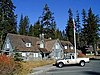 | December 1, 1988 (#88002622) | Munson Valley Rd. 42°53′52″N 122°08′04″W / 42.897778°N 122.134444°W / 42.897778; -122.134444 (Munson Valley Historic District) | Crater Lake National Park | |
| 23 | Oregon Bank Building | 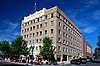 | September 10, 1987 (#87001525) | 905 Main St. 42°13′38″N 121°46′45″W / 42.227222°N 121.779167°W / 42.227222; -121.779167 (Oregon Bank Building) | Klamath Falls | |
| 24 | Point Comfort Lodge | 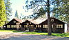 | December 31, 1979 (#79002080) | 27505 Rocky Point Rd. 42°28′18″N 122°05′24″W / 42.471745°N 122.090075°W / 42.471745; -122.090075 (Point Comfort Lodge) | Rocky Point | |
| 25 | Richardson–Ulrich House |  | August 11, 1988 (#88001244) | 636 Conger Ave. 42°13′24″N 121°47′40″W / 42.223381°N 121.794528°W / 42.223381; -121.794528 (Richardson–Ulrich House) | Klamath Falls | |
| 26 | Rim Drive Historic District |  | January 30, 2008 (#08000041) | Rim Drive along edge of caldera surrounding Crater Lake 42°57′24″N 122°02′49″W / 42.956746°N 122.046882°W / 42.956746; -122.046882 (Rim Drive Historic District) | Crater Lake National Park | |
| 27 | Rim Village Historic District |  | September 18, 1997 (#97001155) | Jct. of Rim Village Rd. and an access rd. 42°54′37″N 122°08′33″W / 42.910278°N 122.1425°W / 42.910278; -122.1425 (Rim Village Historic District) | Crater Lake National Park | |
| 28 | Sinnott Memorial Building No. 67 |  | December 1, 1988 (#88002623) | Rim Dr., near Rim Village Campground 42°54′42″N 122°08′33″W / 42.911667°N 122.1425°W / 42.911667; -122.1425 (Sinnott Memorial Building No. 67) | Crater Lake National Park | |
| 29 | Valley Hospital |  | September 8, 1988 (#88001524) | 405 Pine St. 42°13′27″N 121°47′06″W / 42.224184°N 121.785026°W / 42.224184; -121.785026 (Valley Hospital) | Klamath Falls | |
| 30 | Watchman Lookout Station No. 168 |  | December 1, 1988 (#88002626) | Off Rim Dr. on The Watchman 42°56′35″N 122°10′21″W / 42.942953°N 122.172419°W / 42.942953; -122.172419 (Watchman Lookout Station No. 168) | Crater Lake National Park |
Former listings
| [5] | Name on the Register | Image | Date listed | Date removed | Location | City or town | Description |
|---|---|---|---|---|---|---|---|
| 1 | Winthrow-Melhase Block | Upload image | June 14, 1982 (#82003730) | December 28, 1994[10] | 4th and Main Sts. | Klamath Falls | Severely damaged by an earthquake on September 20, 1993. |
See also
 Oregon portal
 National Register of Historic Places portal


- National Register of Historic Places listings in Oregon
- Listings in neighboring counties: Deschutes, Douglas, Jackson, Lake, Lane, Modoc, Siskiyou
- List of National Historic Landmarks in Oregon
- Historic preservation
- History of Oregon
- Lists of Oregon-related topics
References
- ^ Andrus, Patrick W.; Shrimpton, Rebecca H.; et al. (2002), How to Apply the National Register Criteria for Evaluation, National Register Bulletin, National Park Service, U.S. Department of the Interior, OCLC 39493977, archived from the original on April 6, 2014, retrieved June 20, 2014.
- ^ National Park Service, National Register of Historic Places Program: Research, archived from the original on February 1, 2015, retrieved January 28, 2015.
- ^ Oregon Parks and Recreation Department, Oregon Historic Sites Database, retrieved August 6, 2015. Note that a simple count of National Register records in this database returns a slightly higher total than actual listings, due to duplicate records. A close reading of detailed query results is necessary to arrive at the precise count.
- ^ National Park Service, United States Department of the Interior, "National Register of Historic Places: Weekly List Actions", retrieved August 16, 2024.
- ^ a b Numbers represent an alphabetical ordering by significant words. Various colorings, defined here, differentiate National Historic Landmarks and historic districts from other NRHP buildings, structures, sites or objects.
- ^ The eight-digit number below each date is the number assigned to each location in the National Register Information System database, which can be viewed by clicking the number.
- ^ National Park Service. "National Historic Landmark Program: NHL Database". Archived from the original on June 6, 2004. Retrieved February 19, 2012.
- ^ Creasey, Andrew (March 14, 2013), "The fall of the house of Goeller", Herald and News, Klamath Falls, archived from the original on March 4, 2016, retrieved January 28, 2014. Note that this source incorrectly states that the house's National Register listing expired in 2013, when in fact only the Oregon historic preservation special assessment property tax benefit expired.
- ^ Huston, Ann E. (May 1990), National Register of Historic Places Registration Form: Klamath Lake Reservation (PDF), retrieved March 3, 2016.
- ^ Weekly Register List 1995, page 4
External links
Map all coordinates using OpenStreetMap
Download coordinates as:
- KML
- GPX (all coordinates)
- GPX (primary coordinates)
- GPX (secondary coordinates)
- Oregon Parks and Recreation Department, National Register Program
- National Park Service, National Register of Historic Places site
 Media related to National Register of Historic Places in Klamath County, Oregon at Wikimedia Commons
- v
- t
- e
by county

- National Historic Landmarks
- Bridges and Tunnels
- National Historic Sites
- National Monuments
| |
|---|---|
| Topics | |
| Lists by state |
|
| Lists by insular areas | |
| Lists by associated state | |
| Other areas | |
| Related | |
| |

Municipalities and communities of Klamath County, Oregon, United States | ||
|---|---|---|
County seat: Klamath Falls | ||
| Cities |  | |
| CDPs | ||
| Other communities | ||
| Indian reservation | ||
| ||


