National Register of Historic Places listings in Malheur County, Oregon

This list presents the full set of buildings, structures, objects, sites, or districts designated on the National Register of Historic Places in Malheur County, Oregon, and offers brief descriptive information about each of them. The National Register recognizes places of national, state, or local historic significance across the United States.[1] Out of over 90,000 National Register sites nationwide,[2] Oregon is home to over 2,000,[3] and 18 of those are found in Malheur County.
This National Park Service list is complete through NPS recent listings posted August 16, 2024.[4]
Current listings
| [5] | Name on the Register | Image | Date listed[6] | Location | City or town | Description |
|---|---|---|---|---|---|---|
| 1 | Birch Creek Ranch Historic Rural Landscape | 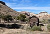 | August 25, 1997 (#97000882) | On the Owyhee River at its confluence with Birch Creek 43°12′54″N 117°30′12″W / 43.214904°N 117.503204°W / 43.214904; -117.503204 (Birch Creek Ranch Historic Rural Landscape) | Jordan Valley vicinity | |
| 2 | James Rowley and Mary J. Blackaby House |  | December 28, 2001 (#01001391) | 717 SW 2nd St. 44°01′14″N 116°58′04″W / 44.020688°N 116.967916°W / 44.020688; -116.967916 (James Rowley and Mary J. Blackaby House) | Ontario | |
| 3 | Jean Baptiste Charbonneau Memorial and Inskip Station Ruins |  | March 14, 1973 (#73001577) | N of Danner off US 95 42°52′00″N 117°20′15″W / 42.866667°N 117.3375°W / 42.866667; -117.3375 (Jean Baptiste Charbonneau Memorial and Inskip Station Ruins) | Danner | |
| 4 | First Bank of Vale |  | March 5, 1992 (#92000132) | 148 Main St. S. 43°58′54″N 117°14′20″W / 43.981667°N 117.238889°W / 43.981667; -117.238889 (First Bank of Vale) | Vale | |
| 5 | Green Lantern Saloon |  | September 6, 1996 (#96000980) | 11 S. 1st St. 43°52′35″N 116°59′38″W / 43.876287°N 116.993862°W / 43.876287; -116.993862 (Green Lantern Saloon) | Nyssa | |
| 6 | Moses and Mary Hart Stone House and Ranch Complex |  | October 1, 2001 (#01000498) | 1 mile (1.6 km) west of Post Office on Bully Creek County Rd. 43°58′53″N 117°43′20″W / 43.981411°N 117.722343°W / 43.981411; -117.722343 (Moses and Mary Hart Stone House and Ranch Complex) | Westfall | |
| 7 | Hotel Western |  | September 6, 1996 (#96000981) | 9 Good Ave. 43°52′33″N 116°59′34″W / 43.875833°N 116.992778°W / 43.875833; -116.992778 (Hotel Western) | Nyssa | |
| 8 | Old Stone House |  | May 19, 1972 (#72001085) | 283 Main St. S. 43°58′51″N 117°14′22″W / 43.980833°N 117.239444°W / 43.980833; -117.239444 (Old Stone House) | Vale | |
| 9 | Oregon Short Line Railroad Depot |  | August 5, 1999 (#99000950) | 300 Depot Lane 44°01′26″N 116°57′42″W / 44.023889°N 116.961667°W / 44.023889; -116.961667 (Oregon Short Line Railroad Depot) | Ontario | |
| 10 | Oregon Trail Historic District |  | October 29, 1975 (#75001589) | 5 miles (8.0 km) southeast of Vale at Lytle Blvd. 43°54′50″N 117°10′35″W / 43.913889°N 117.176389°W / 43.913889; -117.176389 (Oregon Trail Historic District) | Vale | |
| 11 | Owyhee Dam Historic District | 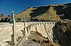 | September 23, 2010 (#10000791) | Owyhee Lake Road 43°35′31″N 117°14′33″W / 43.591825°N 117.242389°W / 43.591825; -117.242389 (Owyhee Dam Historic District) | Adrian vicinity | Historic district including Owyhee Dam |
| 12 | Pelota Fronton |  | May 19, 1972 (#72001084) | Bassett St. (U.S. 95) 42°58′28″N 117°03′10″W / 42.974410°N 117.052896°W / 42.974410; -117.052896 (Pelota Fronton) | Jordan Valley | |
| 13 | Rex Theater |  | February 25, 2022 (#100007459) | 240 A St. West 43°58′55″N 117°14′30″W / 43.9819°N 117.2416°W / 43.9819; -117.2416 (Rex Theater) | Vale | |
| 14 | Sheep Ranch Fortified House |  | November 1, 1974 (#74001695) | 3192 Old I-O-N Highway[7] 42°55′12″N 117°32′50″W / 42.919902°N 117.547140°W / 42.919902; -117.547140 (Sheep Ranch Fortified House) | Arock vicinity | |
| 15 | Al Thompson and Son's Feed and Seed Company |  | September 6, 1996 (#96000982) | 117 Good Ave. 43°52′32″N 116°59′41″W / 43.875666°N 116.994667°W / 43.875666; -116.994667 (Al Thompson and Son's Feed and Seed Company) | Nyssa | |
| 16 | Vale Drug Store | 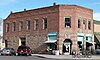 | September 6, 2002 (#02000950) | 158 Main St. N. 43°58′56″N 117°14′20″W / 43.982222°N 117.238889°W / 43.982222; -117.238889 (Vale Drug Store) | Vale | |
| 17 | Vale Hotel and Grand Opera House |  | August 1, 1984 (#84003032) | 123 Main St. S. 43°58′56″N 117°14′43″W / 43.982222°N 117.245278°W / 43.982222; -117.245278 (Vale Hotel and Grand Opera House) | Vale | |
| 18 | Vinsonhaler Blacksmith Shop |  | September 6, 1996 (#96000983) | 122 Good Ave. 43°52′34″N 116°59′41″W / 43.876054°N 116.994706°W / 43.876054; -116.994706 (Vinsonhaler Blacksmith Shop) | Nyssa |
Former listings
| [5] | Name on the Register | Image | Date listed | Date removed | Location | City or town | Description |
|---|---|---|---|---|---|---|---|
| 1 | Vale Independent Order of Odd Fellows Hall |  | December 6, 2016 (#16000822) | March 6, 2018 | 122 Main St. S. 43°58′54″N 117°14′23″W / 43.981701°N 117.239796°W / 43.981701; -117.239796 (Vale Independent Order of Odd Fellows Hall) | Vale |
See also
 Oregon portal
 National Register of Historic Places portal


- National Register of Historic Places listings in Oregon
- Listings in neighboring counties: Baker, Canyon, Grant, Harney, Humboldt, Owyhee, Payette, Washington
- Historic preservation
- History of Oregon
- Lists of Oregon-related topics
References
- ^ Andrus, Patrick W.; Shrimpton, Rebecca H.; et al. (2002), How to Apply the National Register Criteria for Evaluation, National Register Bulletin, National Park Service, U.S. Department of the Interior, OCLC 39493977, archived from the original on April 6, 2014, retrieved June 20, 2014.
- ^ National Park Service, National Register of Historic Places Program: Research, archived from the original on February 1, 2015, retrieved January 28, 2015.
- ^ Oregon Parks and Recreation Department, Oregon Historic Sites Database, retrieved August 6, 2015. Note that a simple count of National Register records in this database returns a slightly higher total than actual listings, due to duplicate records. A close reading of detailed query results is necessary to arrive at the precise count.
- ^ National Park Service, United States Department of the Interior, "National Register of Historic Places: Weekly List Actions", retrieved August 16, 2024.
- ^ a b Numbers represent an alphabetical ordering by significant words. Various colorings, defined here, differentiate National Historic Landmarks and historic districts from other NRHP buildings, structures, sites or objects.
- ^ The eight-digit number below each date is the number assigned to each location in the National Register Information System database, which can be viewed by clicking the number.
- ^ Malheur County Assessor (September 19, 2015), Assessment Search, archived from the original (online database) on September 19, 2015, retrieved September 19, 2015.
External links
Map all coordinates using OpenStreetMap
Download coordinates as:
- KML
- GPX (all coordinates)
- GPX (primary coordinates)
- GPX (secondary coordinates)
- Oregon Parks and Recreation Department, National Register Program
- National Park Service, National Register of Historic Places site
 Media related to National Register of Historic Places in Malheur County, Oregon at Wikimedia Commons
- v
- t
- e
by county

- National Historic Landmarks
- Bridges and Tunnels
- National Historic Sites
- National Monuments
| |
|---|---|
| Topics | |
| Lists by state |
|
| Lists by insular areas | |
| Lists by associated state | |
| Other areas | |
| Related | |
| |

Municipalities and communities of Malheur County, Oregon, United States | ||
|---|---|---|
County seat: Vale | ||
| Cities |  | |
| CDPs | ||
| Other communities | ||
| Ghost town | ||
| Indian reservation | ||
| Footnotes | ‡This populated place also has portions in an adjacent county or counties | |
| ||


