List of listed buildings in Inchture, Perth and Kinross
This is a list of listed buildings in the parish of Inchture in Perth and Kinross, Scotland.
Map all coordinates using OpenStreetMap
Download coordinates as:
- KML
- GPX (all coordinates)
- GPX (primary coordinates)
- GPX (secondary coordinates)
List
| Name | Location | Date Listed | Grid Ref. [note 1] | Geo-coordinates | Notes | LB Number [note 2] | Image |
|---|---|---|---|---|---|---|---|
| Castlehill, Baledgarno | 56°27′37″N 3°10′35″W / 56.460279°N 3.176422°W / 56.460279; -3.176422 (Castlehill, Baledgarno) | Category B | 11759 |  Upload Photo | |||
| Smith, Filling Station And Scott Inchture Village | 56°26′44″N 3°10′05″W / 56.445471°N 3.168016°W / 56.445471; -3.168016 (Smith, Filling Station And Scott Inchture Village) | Category C(S) | 11772 | Upload Photo | |||
| Post Office And House, Inchture Village | 56°26′45″N 3°10′08″W / 56.445787°N 3.168804°W / 56.445787; -3.168804 (Post Office And House, Inchture Village) | Category C(S) | 11776 | Upload Photo | |||
| Inchture Lodge And Gates (Formerly To Rossie Priory | 56°27′47″N 3°09′46″W / 56.463131°N 3.162699°W / 56.463131; -3.162699 (Inchture Lodge And Gates (Formerly To Rossie Priory) | Category B | 11784 | Upload Photo | |||
| The Cottage, Wester Ballindean | 56°26′58″N 3°12′18″W / 56.449385°N 3.205028°W / 56.449385; -3.205028 (The Cottage, Wester Ballindean) | Category C(S) | 11765 | Upload Photo | |||
| Crighton, Watson And 2 Vacant Houses, Inchture Village | 56°26′42″N 3°10′11″W / 56.445023°N 3.169787°W / 56.445023; -3.169787 (Crighton, Watson And 2 Vacant Houses, Inchture Village) | Category B | 11774 | Upload Photo | |||
| Inchture Hotel And Adjoining Cottage. Inchture Village | 56°26′42″N 3°10′17″W / 56.444901°N 3.171259°W / 56.444901; -3.171259 (Inchture Hotel And Adjoining Cottage. Inchture Village) | Category C(S) | 11782 | Upload Photo | |||
| Rossie Church Within Rossie Priory Policies | 56°27′51″N 3°09′04″W / 56.464056°N 3.151237°W / 56.464056; -3.151237 (Rossie Church Within Rossie Priory Policies) | Category A | 11786 | Upload Photo | |||
| Baledgarno, N.W. Group Of Cottages, Baledgarno Mill. (Miller, Alcorn) | 56°27′30″N 3°10′33″W / 56.458218°N 3.175872°W / 56.458218; -3.175872 (Baledgarno, N.W. Group Of Cottages, Baledgarno Mill. (Miller, Alcorn)) | Category B | 11791 | Upload Photo | |||
| Baledgarno, Steading | 56°27′29″N 3°10′35″W / 56.458142°N 3.176291°W / 56.458142; -3.176291 (Baledgarno, Steading) | Category C(S) | 11757 | Upload Photo | |||
| Burnside, Baledgarno | 56°27′26″N 3°10′30″W / 56.457104°N 3.174945°W / 56.457104; -3.174945 (Burnside, Baledgarno) | Category B | 11758 | Upload Photo | |||
| Inchture School | 56°26′44″N 3°10′09″W / 56.445569°N 3.169106°W / 56.445569; -3.169106 (Inchture School) | Category C(S) | 11777 | Upload Photo | |||
| Tighanrathad. (Runciman) Inchture Village | 56°26′44″N 3°10′12″W / 56.445461°N 3.169995°W / 56.445461; -3.169995 (Tighanrathad. (Runciman) Inchture Village) | Category C(S) | 11779 | Upload Photo | |||
| Ballindean Walled Garden | 56°27′15″N 3°11′26″W / 56.45417°N 3.190512°W / 56.45417; -3.190512 (Ballindean Walled Garden) | Category B | 13463 | Upload Photo | |||
| Baledgarno, Farmhouse. (R. W. Wilson) | 56°27′28″N 3°10′37″W / 56.457895°N 3.176819°W / 56.457895; -3.176819 (Baledgarno, Farmhouse. (R. W. Wilson)) | Category B | 11756 | Upload Photo | |||
| New Cottage, Morven And Corner House, Inchture Village | 56°26′45″N 3°10′06″W / 56.445907°N 3.168435°W / 56.445907; -3.168435 (New Cottage, Morven And Corner House, Inchture Village) | Category C(S) | 11775 | Upload Photo | |||
| Baledgarno, N.E. Group Of Cottages | 56°27′31″N 3°10′31″W / 56.458521°N 3.175183°W / 56.458521; -3.175183 (Baledgarno, N.E. Group Of Cottages) | Category B | 11789 |  Upload another image | |||
| The Knapp Rossie Estate Sawmill Stable | 56°28′19″N 3°10′27″W / 56.471873°N 3.174184°W / 56.471873; -3.174184 (The Knapp Rossie Estate Sawmill Stable) | Category B | 13318 | Upload Photo | |||
| The Knapp North Lodge | 56°28′24″N 3°10′56″W / 56.473406°N 3.182088°W / 56.473406; -3.182088 (The Knapp North Lodge) | Category B | 13319 | Upload Photo | |||
| Ballindean West Lodge | 56°27′04″N 3°12′09″W / 56.45108°N 3.202551°W / 56.45108; -3.202551 (Ballindean West Lodge) | Category B | 11763 | Upload Photo | |||
| Moncur Castle, Within Rossie Priory Policies | 56°27′09″N 3°09′50″W / 56.452364°N 3.164025°W / 56.452364; -3.164025 (Moncur Castle, Within Rossie Priory Policies) | Category B | 11785 |  Upload another image | |||
| Baledgarno, Footbridge Over Baledgarno Burn | 56°27′31″N 3°10′33″W / 56.45857°N 3.175737°W / 56.45857; -3.175737 (Baledgarno, Footbridge Over Baledgarno Burn) | Category C(S) | 11793 | Upload Photo | |||
| Ballindean Steading | 56°27′15″N 3°11′35″W / 56.454217°N 3.193142°W / 56.454217; -3.193142 (Ballindean Steading) | Category B | 13480 | Upload Photo | |||
| Wester Ballindean Cottages | 56°27′00″N 3°12′20″W / 56.450064°N 3.205423°W / 56.450064; -3.205423 (Wester Ballindean Cottages) | Category B | 11766 | Upload Photo | |||
| Inchture Parish Church, Churchyard | 56°26′44″N 3°10′03″W / 56.445646°N 3.167567°W / 56.445646; -3.167567 (Inchture Parish Church, Churchyard) | Category C(S) | 11771 | Upload Photo | |||
| Carselea (Logie) And Milne, Inchture Village | 56°26′44″N 3°10′11″W / 56.445474°N 3.16959°W / 56.445474; -3.16959 (Carselea (Logie) And Milne, Inchture Village) | Category B | 11778 | Upload Photo | |||
| Crossgates. Inchture Village | 56°26′36″N 3°10′27″W / 56.443464°N 3.174151°W / 56.443464; -3.174151 (Crossgates. Inchture Village) | Category B | 11783 | Upload Photo | |||
| Baledgarno, S.W. Group Of Cottages (Napier, J.Crichton | 56°27′28″N 3°10′34″W / 56.45791°N 3.176106°W / 56.45791; -3.176106 (Baledgarno, S.W. Group Of Cottages (Napier, J.Crichton) | Category C(S) | 11792 | Upload Photo | |||
| Inchmartine, Lodge House And Gatepiers | 56°26′08″N 3°11′40″W / 56.435543°N 3.194471°W / 56.435543; -3.194471 (Inchmartine, Lodge House And Gatepiers) | Category B | 11767 | Upload Photo | |||
| Wester Ballindean Farmhouse | 56°27′00″N 3°12′23″W / 56.449921°N 3.206311°W / 56.449921; -3.206311 (Wester Ballindean Farmhouse) | Category C(S) | 12438 | Upload Photo | |||
| Ballindean House | 56°27′21″N 3°11′18″W / 56.455817°N 3.188341°W / 56.455817; -3.188341 (Ballindean House) | Category A | 11760 | 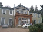 Upload another image | |||
| Ballindean South Lodge And Gates, | 56°27′03″N 3°11′20″W / 56.450951°N 3.188902°W / 56.450951; -3.188902 (Ballindean South Lodge And Gates,) | Category B | 11761 | Upload Photo | |||
| Inchture Parish Church | 56°26′44″N 3°10′03″W / 56.445646°N 3.167567°W / 56.445646; -3.167567 (Inchture Parish Church) | Category B | 11770 | Upload Photo | |||
| Rose Cottage (Urquhart) And Mudie. Inchture Village | 56°26′43″N 3°10′06″W / 56.445359°N 3.168434°W / 56.445359; -3.168434 (Rose Cottage (Urquhart) And Mudie. Inchture Village) | Category C(S) | 11773 | Upload Photo | |||
| Market Cross, Old Rossie Within Rossie Priory Policies | 56°27′48″N 3°09′01″W / 56.463353°N 3.150404°W / 56.463353; -3.150404 (Market Cross, Old Rossie Within Rossie Priory Policies) | Category A | 11787 | Upload Photo | |||
| Rossie Priory | 56°27′50″N 3°09′42″W / 56.463959°N 3.161621°W / 56.463959; -3.161621 (Rossie Priory) | Category B | 11788 | Upload Photo | |||
| The Knapp Rossie Estate Sawmill Seasoning Shed | 56°28′19″N 3°10′25″W / 56.471815°N 3.173695°W / 56.471815; -3.173695 (The Knapp Rossie Estate Sawmill Seasoning Shed) | Category C(S) | 13317 | Upload Photo | |||
| Ballindean Nursery Lodge | 56°27′22″N 3°11′23″W / 56.455974°N 3.189757°W / 56.455974; -3.189757 (Ballindean Nursery Lodge) | Category B | 11762 | Upload Photo | |||
| Easter Ballindean, Farmhouse | 56°27′15″N 3°11′35″W / 56.454217°N 3.193142°W / 56.454217; -3.193142 (Easter Ballindean, Farmhouse) | Category C(S) | 11764 | Upload Photo | |||
| Baledgarno, S.E. Group Of Cottages | 56°27′28″N 3°10′26″W / 56.457824°N 3.17388°W / 56.457824; -3.17388 (Baledgarno, S.E. Group Of Cottages) | Category B | 11790 | Upload Photo |
Key
The scheme for classifying buildings in Scotland is:
- Category A: "buildings of national or international importance, either architectural or historic; or fine, little-altered examples of some particular period, style or building type."[1]
- Category B: "buildings of regional or more than local importance; or major examples of some particular period, style or building type, which may have been altered."[1]
- Category C: "buildings of local importance; lesser examples of any period, style, or building type, as originally constructed or moderately altered; and simple traditional buildings which group well with other listed buildings."[1]
In March 2016 there were 47,288 listed buildings in Scotland. Of these, 8% were Category A, and 50% were Category B, with the remaining 42% being Category C.[2]
Notes
- ^ Sometimes known as OSGB36, the grid reference (where provided) is based on the British national grid reference system used by the Ordnance Survey.
• "Guide to National Grid". Ordnance Survey. Retrieved 12 December 2007.
• "Get-a-map". Ordnance Survey. Retrieved 17 December 2007. - ^ Historic Environment Scotland assign a unique alphanumeric identifier to each designated site in Scotland, for listed buildings this always begins with "LB", for example "LB12345".
References
- All entries, addresses and coordinates are based on data from Historic Scotland. This data falls under the Open Government Licence
- ^ a b c "What is Listing?". Historic Environment Scotland. Retrieved 29 May 2018.
- ^ Scotland's Historic Environment Audit 2016 (PDF). Historic Environment Scotland and the Built Environment Forum Scotland. pp. 15–16. Retrieved 29 May 2018.
- v
- t
- e
- Aberdalgie
- Aberfeldy
- Abernethy
- Abernyte
- Alyth
- Ardoch
- Arngask
- Auchterarder
- Auchtergaven
- Bendochy
- Blackford
- Blair Atholl
- Blairgowrie and Rattray
- Blairgowrie
- Caputh
- Cargill
- Cleish
- Clunie
- Collace
- Comrie
- Coupar Angus
- Crieff
- Dron
- Dull
- Dunbarney
- Dunkeld and Dowally
- Dunning
- Errol
- Findo Gask
- Forgandenny
- Forteviot
- Fortingall
- Fossoway
- Fowlis Wester
- Glendevon
- Inchture
- Kenmore
- Kettins
- Kilspindie
- Kinclaven
- Kinfauns
- Kinloch
- Kinnaird
- Kinnoull
- Kinross
- Kirkmichael
- Lethendy
- Liff and Benvie
- Little Dunkeld
- Logiealmond
- Logierait
- Longforgan
- Madderty
- Meigle
- Methven
- Moneydie
- Monzievaird and Strowan
- Moulin
- Muckhart
- Muthill
- Orwell
- Perth
- Pitlochry
- Portmoak
- Rattray
- Redgorton
- Rhynd
- Scone
- St Madoes
- St Martins
- Tibbermore
- Trinity Gask
- Weem


