List of listed buildings in Kettins, Perth and Kinross
This is a list of listed buildings in the parish of Kettins in Perth and Kinross, Scotland.
Map all coordinates using OpenStreetMap
Download coordinates as:
- KML
- GPX (all coordinates)
- GPX (primary coordinates)
- GPX (secondary coordinates)
List
| Name | Location | Date Listed | Grid Ref. [note 1] | Geo-coordinates | Notes | LB Number [note 2] | Image |
|---|---|---|---|---|---|---|---|
| Kettins Parish Kirk | 56°32′14″N 3°14′27″W / 56.537201°N 3.240729°W / 56.537201; -3.240729 (Kettins Parish Kirk) | Category B | 11443 | 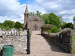 Upload another image | |||
| Hallyburton Estate, Baldinny Farmhouse | 56°31′45″N 3°14′03″W / 56.529225°N 3.234112°W / 56.529225; -3.234112 (Hallyburton Estate, Baldinny Farmhouse) | Category C(S) | 51602 |  Upload Photo | |||
| Lintrose House - Doocot | 56°31′38″N 3°15′44″W / 56.527308°N 3.262174°W / 56.527308; -3.262174 (Lintrose House - Doocot) | Category B | 11404 | Upload Photo | |||
| Parish Kirk - Cross | 56°32′14″N 3°14′26″W / 56.537274°N 3.240569°W / 56.537274; -3.240569 (Parish Kirk - Cross) | Category B | 11445 | Upload Photo | |||
| Hallyburton Estate, Stables And Ancillary Building | 56°32′04″N 3°13′24″W / 56.534542°N 3.223455°W / 56.534542; -3.223455 (Hallyburton Estate, Stables And Ancillary Building) | Category B | 51606 | Upload Photo | |||
| Parish Kirk - Belfry | 56°32′14″N 3°14′27″W / 56.537201°N 3.240729°W / 56.537201; -3.240729 (Parish Kirk - Belfry) | Category B | 11444 | Upload Photo | |||
| Hallyburton Estate, Walled Garden, Store And Cottages | 56°31′50″N 3°13′29″W / 56.530541°N 3.224643°W / 56.530541; -3.224643 (Hallyburton Estate, Walled Garden, Store And Cottages) | Category C(S) | 51608 | Upload Photo | |||
| Hallyburton Estate, West Lodge, Gate And Quadrant Walls | 56°31′37″N 3°14′09″W / 56.527015°N 3.235909°W / 56.527015; -3.235909 (Hallyburton Estate, West Lodge, Gate And Quadrant Walls) | Category B | 51609 | Upload Photo | |||
| Parish Kirk Manse | 56°32′13″N 3°14′26″W / 56.536943°N 3.240493°W / 56.536943; -3.240493 (Parish Kirk Manse) | Category B | 11401 | Upload Photo | |||
| Lintrose - Sawmill. Bridge Over Kinnochtry Burn | 56°31′29″N 3°15′48″W / 56.524718°N 3.263274°W / 56.524718; -3.263274 (Lintrose - Sawmill. Bridge Over Kinnochtry Burn) | Category B | 11406 | Upload Photo | |||
| Lintrose - Sawmill | 56°31′28″N 3°15′48″W / 56.524503°N 3.2633°W / 56.524503; -3.2633 (Lintrose - Sawmill) | Category B | 11405 | Upload Photo | |||
| Keilor House - Doocot | 56°32′54″N 3°11′30″W / 56.548292°N 3.191676°W / 56.548292; -3.191676 (Keilor House - Doocot) | Category B | 11411 | Upload Photo | |||
| Hallyburton Estate, Garage And Game Larders | 56°32′02″N 3°13′27″W / 56.533915°N 3.224183°W / 56.533915; -3.224183 (Hallyburton Estate, Garage And Game Larders) | Category C(S) | 51603 | Upload Photo | |||
| Newton Of Ballunie | 56°32′24″N 3°12′41″W / 56.540086°N 3.211437°W / 56.540086; -3.211437 (Newton Of Ballunie) | Category B | 13752 | Upload Photo | |||
| Beechwood | 56°32′12″N 3°14′55″W / 56.536547°N 3.248594°W / 56.536547; -3.248594 (Beechwood) | Category B | 11403 | Upload Photo | |||
| Peattie Mill Bridge | 56°31′01″N 3°15′34″W / 56.517066°N 3.259444°W / 56.517066; -3.259444 (Peattie Mill Bridge) | Category C(S) | 11407 | Upload Photo | |||
| Parish Kirkyard - Lych Gate | 56°32′14″N 3°14′27″W / 56.537201°N 3.240729°W / 56.537201; -3.240729 (Parish Kirkyard - Lych Gate) | Category C(S) | 11400 | Upload Photo | |||
| Kettins Bridge Over Kettins Burn | 56°32′16″N 3°14′21″W / 56.53771°N 3.239217°W / 56.53771; -3.239217 (Kettins Bridge Over Kettins Burn) | Category B | 11402 | Upload Photo | |||
| Pitcur Castle | 56°31′08″N 3°13′05″W / 56.518935°N 3.218028°W / 56.518935; -3.218028 (Pitcur Castle) | Category B | 11408 |  Upload another image | |||
| Pitcur Earth House | 56°31′21″N 3°12′57″W / 56.522531°N 3.215932°W / 56.522531; -3.215932 (Pitcur Earth House) | Category B | 11409 | Upload Photo | |||
| Baldowrie Symbol Stone | 56°32′39″N 3°11′00″W / 56.544193°N 3.183432°W / 56.544193; -3.183432 (Baldowrie Symbol Stone) | Category B | 11410 |  Upload another image | |||
| Hallyburton Estate, Sundial | 56°32′00″N 3°13′28″W / 56.533364°N 3.224426°W / 56.533364; -3.224426 (Hallyburton Estate, Sundial) | Category A | 51607 | Upload Photo | |||
| Parish Kirkyard - Sculptured Stone | 56°32′15″N 3°14′27″W / 56.537369°N 3.24093°W / 56.537369; -3.24093 (Parish Kirkyard - Sculptured Stone) | Category B | 13758 | Upload Photo | |||
| Kirkyard Walls | 56°32′14″N 3°14′27″W / 56.537201°N 3.240729°W / 56.537201; -3.240729 (Kirkyard Walls) | Category B | 11399 | Upload Photo | |||
| Hallyburton Estate, Ha-Ha To Nw And Se Of Hallyburton House And To Main Driveway | 56°31′58″N 3°13′24″W / 56.532754°N 3.223414°W / 56.532754; -3.223414 (Hallyburton Estate, Ha-Ha To Nw And Se Of Hallyburton House And To Main Driveway) | Category B | 51604 | Upload Photo | |||
| Hallyburton Estate, Hallyburton House, Formal Garden, Terracing And Lorimer Gate | 56°32′01″N 3°13′28″W / 56.533552°N 3.224497°W / 56.533552; -3.224497 (Hallyburton Estate, Hallyburton House, Formal Garden, Terracing And Lorimer Gate) | Category A | 51605 | Upload Photo |
Key
The scheme for classifying buildings in Scotland is:
- Category A: "buildings of national or international importance, either architectural or historic; or fine, little-altered examples of some particular period, style or building type."[1]
- Category B: "buildings of regional or more than local importance; or major examples of some particular period, style or building type, which may have been altered."[1]
- Category C: "buildings of local importance; lesser examples of any period, style, or building type, as originally constructed or moderately altered; and simple traditional buildings which group well with other listed buildings."[1]
In March 2016 there were 47,288 listed buildings in Scotland. Of these, 8% were Category A, and 50% were Category B, with the remaining 42% being Category C.[2]
Notes
- ^ Sometimes known as OSGB36, the grid reference (where provided) is based on the British national grid reference system used by the Ordnance Survey.
• "Guide to National Grid". Ordnance Survey. Retrieved 12 December 2007.
• "Get-a-map". Ordnance Survey. Retrieved 17 December 2007. - ^ Historic Environment Scotland assign a unique alphanumeric identifier to each designated site in Scotland, for listed buildings this always begins with "LB", for example "LB12345".
References
- All entries, addresses, and coordinates are based on data from Historic Scotland. This data falls under the Open Government Licence
- ^ a b c "What is Listing?". Historic Environment Scotland. Retrieved 29 May 2018.
- ^ Scotland's Historic Environment Audit 2016 (PDF). Historic Environment Scotland and the Built Environment Forum Scotland. pp. 15–16. Retrieved 29 May 2018.
- v
- t
- e
- Aberdalgie
- Aberfeldy
- Abernethy
- Abernyte
- Alyth
- Ardoch
- Arngask
- Auchterarder
- Auchtergaven
- Bendochy
- Blackford
- Blair Atholl
- Blairgowrie and Rattray
- Blairgowrie
- Caputh
- Cargill
- Cleish
- Clunie
- Collace
- Comrie
- Coupar Angus
- Crieff
- Dron
- Dull
- Dunbarney
- Dunkeld and Dowally
- Dunning
- Errol
- Findo Gask
- Forgandenny
- Forteviot
- Fortingall
- Fossoway
- Fowlis Wester
- Glendevon
- Inchture
- Kenmore
- Kettins
- Kilspindie
- Kinclaven
- Kinfauns
- Kinloch
- Kinnaird
- Kinnoull
- Kinross
- Kirkmichael
- Lethendy
- Liff and Benvie
- Little Dunkeld
- Logiealmond
- Logierait
- Longforgan
- Madderty
- Meigle
- Methven
- Moneydie
- Monzievaird and Strowan
- Moulin
- Muckhart
- Muthill
- Orwell
- Perth
- Pitlochry
- Portmoak
- Rattray
- Redgorton
- Rhynd
- Scone
- St Madoes
- St Martins
- Tibbermore
- Trinity Gask
- Weem


