List of listed buildings in Kinfauns, Perth and Kinross
This is a list of listed buildings in the parish of Kinfauns in Perth and Kinross, Scotland.
Map all coordinates using OpenStreetMap
Download coordinates as:
- KML
- GPX (all coordinates)
- GPX (primary coordinates)
- GPX (secondary coordinates)
List
| Name | Location | Date Listed | Grid Ref. [note 1] | Geo-coordinates | Notes | LB Number [note 2] | Image |
|---|---|---|---|---|---|---|---|
| Kinfauns Churchyard | 56°23′07″N 3°21′07″W / 56.385309°N 3.351866°W / 56.385309; -3.351866 (Kinfauns Churchyard) | Category C(S) | 11996 |  Upload Photo | |||
| Glencarse House | 56°23′21″N 3°18′17″W / 56.38904°N 3.304716°W / 56.38904; -3.304716 (Glencarse House) | Category C(S) | 11957 | Upload Photo | |||
| Castle Farm | 56°23′23″N 3°22′58″W / 56.389811°N 3.382819°W / 56.389811; -3.382819 (Castle Farm) | Category B | 11965 | Upload Photo | |||
| Kinfauns Parish Church | 56°23′08″N 3°21′08″W / 56.385459°N 3.352195°W / 56.385459; -3.352195 (Kinfauns Parish Church) | Category C(S) | 11995 | 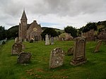 Upload another image | |||
| Kinfauns House (Former Manse) | 56°23′07″N 3°20′48″W / 56.385285°N 3.346666°W / 56.385285; -3.346666 (Kinfauns House (Former Manse)) | Category C(S) | 11950 | Upload Photo | |||
| Glencarse House, Dovecot At Steading | 56°23′25″N 3°18′09″W / 56.390267°N 3.302554°W / 56.390267; -3.302554 (Glencarse House, Dovecot At Steading) | Category C(S) | 11958 | Upload Photo | |||
| Glencarse House, West Lodge And Gatepiers | 56°23′14″N 3°18′28″W / 56.387201°N 3.307827°W / 56.387201; -3.307827 (Glencarse House, West Lodge And Gatepiers) | Category B | 11952 |  Upload another image | |||
| Kinfauns Castle Walled Garden Gateway And Stairs At N. Wall | 56°23′10″N 3°22′31″W / 56.386138°N 3.375381°W / 56.386138; -3.375381 (Kinfauns Castle Walled Garden Gateway And Stairs At N. Wall) | Category C(S) | 11954 | Upload Photo | |||
| Bowes Lodge | 56°23′07″N 3°22′48″W / 56.385225°N 3.379948°W / 56.385225; -3.379948 (Bowes Lodge) | Category C(S) | 11960 | Upload Photo | |||
| Home Farm, Kinfauns Castle, Farmhouse | 56°23′11″N 3°22′45″W / 56.386357°N 3.379098°W / 56.386357; -3.379098 (Home Farm, Kinfauns Castle, Farmhouse) | Category B | 11961 | Upload Photo | |||
| Seggieden Ice House | 56°22′41″N 3°20′56″W / 56.37811°N 3.348777°W / 56.37811; -3.348777 (Seggieden Ice House) | Category C(S) | 11951 |  Upload another image | |||
| Kinfauns Schoolhouse | 56°23′06″N 3°21′00″W / 56.385123°N 3.349964°W / 56.385123; -3.349964 (Kinfauns Schoolhouse) | Category B | 11997 | Upload Photo | |||
| Kinfauns Castle | 56°23′18″N 3°22′39″W / 56.388432°N 3.377586°W / 56.388432; -3.377586 (Kinfauns Castle) | Category A | 11955 |  Upload another image | |||
| Binnhill Tower | 56°23′18″N 3°22′01″W / 56.388395°N 3.367056°W / 56.388395; -3.367056 (Binnhill Tower) | Category B | 11956 |  Upload another image | |||
| Kinnoull Tower, Kinnoull Hill | 56°23′20″N 3°23′46″W / 56.388944°N 3.39607°W / 56.388944; -3.39607 (Kinnoull Tower, Kinnoull Hill) | Category B | 11963 |  Upload another image | |||
| Glendoick House, Walled Garden, Sundial Chair | 56°23′49″N 3°17′16″W / 56.39706°N 3.287913°W / 56.39706; -3.287913 (Glendoick House, Walled Garden, Sundial Chair) | Category B | 11967 | Upload Photo | |||
| Home Farm, Dairy Kinfauns Castle | 56°23′10″N 3°22′46″W / 56.386164°N 3.379496°W / 56.386164; -3.379496 (Home Farm, Dairy Kinfauns Castle) | Category B | 13794 | Upload Photo | |||
| Tofthill Farm House | 56°22′30″N 3°19′57″W / 56.374871°N 3.332551°W / 56.374871; -3.332551 (Tofthill Farm House) | Category C(S) | 11953 | Upload Photo | |||
| West Lodge, Kinfauns Castle, Gatepiers | 56°22′59″N 3°24′34″W / 56.382925°N 3.409487°W / 56.382925; -3.409487 (West Lodge, Kinfauns Castle, Gatepiers) | Category C(S) | 11962 |  Upload another image | |||
| Rockdale Cottage | 56°23′17″N 3°23′28″W / 56.387994°N 3.391063°W / 56.387994; -3.391063 (Rockdale Cottage) | Category B | 11964 | Upload Photo | |||
| Glendoick House, Walled Garden | 56°23′50″N 3°17′15″W / 56.397315°N 3.287582°W / 56.397315; -3.287582 (Glendoick House, Walled Garden) | Category C(S) | 13795 | Upload Photo | |||
| Glencarse All Saints Episcopal Church | 56°22′49″N 3°18′09″W / 56.380159°N 3.302485°W / 56.380159; -3.302485 (Glencarse All Saints Episcopal Church) | Category C(S) | 11968 |  Upload another image | |||
| Glendoick House | 56°23′53″N 3°17′08″W / 56.398028°N 3.285516°W / 56.398028; -3.285516 (Glendoick House) | Category A | 11966 | 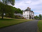 Upload another image | |||
| Kinfauns Old Parish Church | 56°23′07″N 3°21′04″W / 56.385236°N 3.351199°W / 56.385236; -3.351199 (Kinfauns Old Parish Church) | Category B | 13796 | Upload Photo | |||
| Glencarse House, Sundial Within Walled Garden | 56°23′26″N 3°18′12″W / 56.390636°N 3.303328°W / 56.390636; -3.303328 (Glencarse House, Sundial Within Walled Garden) | Category B | 11959 | Upload Photo |
Key
The scheme for classifying buildings in Scotland is:
- Category A: "buildings of national or international importance, either architectural or historic; or fine, little-altered examples of some particular period, style or building type."[1]
- Category B: "buildings of regional or more than local importance; or major examples of some particular period, style or building type, which may have been altered."[1]
- Category C: "buildings of local importance; lesser examples of any period, style, or building type, as originally constructed or moderately altered; and simple traditional buildings which group well with other listed buildings."[1]
In March 2016 there were 47,288 listed buildings in Scotland. Of these, 8% were Category A, and 50% were Category B, with the remaining 42% being Category C.[2]
Notes
- ^ Sometimes known as OSGB36, the grid reference (where provided) is based on the British national grid reference system used by the Ordnance Survey.
• "Guide to National Grid". Ordnance Survey. Retrieved 12 December 2007.
• "Get-a-map". Ordnance Survey. Retrieved 17 December 2007. - ^ Historic Environment Scotland assign a unique alphanumeric identifier to each designated site in Scotland, for listed buildings this always begins with "LB", for example "LB12345".
References
- All entries, addresses and coordinates are based on data from Historic Scotland. This data falls under the Open Government Licence
- ^ a b c "What is Listing?". Historic Environment Scotland. Retrieved 29 May 2018.
- ^ Scotland's Historic Environment Audit 2016 (PDF). Historic Environment Scotland and the Built Environment Forum Scotland. pp. 15–16. Retrieved 29 May 2018.
- v
- t
- e
- Aberdalgie
- Aberfeldy
- Abernethy
- Abernyte
- Alyth
- Ardoch
- Arngask
- Auchterarder
- Auchtergaven
- Bendochy
- Blackford
- Blair Atholl
- Blairgowrie and Rattray
- Blairgowrie
- Caputh
- Cargill
- Cleish
- Clunie
- Collace
- Comrie
- Coupar Angus
- Crieff
- Dron
- Dull
- Dunbarney
- Dunkeld and Dowally
- Dunning
- Errol
- Findo Gask
- Forgandenny
- Forteviot
- Fortingall
- Fossoway
- Fowlis Wester
- Glendevon
- Inchture
- Kenmore
- Kettins
- Kilspindie
- Kinclaven
- Kinfauns
- Kinloch
- Kinnaird
- Kinnoull
- Kinross
- Kirkmichael
- Lethendy
- Liff and Benvie
- Little Dunkeld
- Logiealmond
- Logierait
- Longforgan
- Madderty
- Meigle
- Methven
- Moneydie
- Monzievaird and Strowan
- Moulin
- Muckhart
- Muthill
- Orwell
- Perth
- Pitlochry
- Portmoak
- Rattray
- Redgorton
- Rhynd
- Scone
- St Madoes
- St Martins
- Tibbermore
- Trinity Gask
- Weem


