List of listed buildings in Kirkmichael, Perth and Kinross
This is a list of listed buildings in the parish of Kirkmichael in Perth and Kinross, Scotland.
Map all coordinates using OpenStreetMap
Download coordinates as:
- KML
- GPX (all coordinates)
- GPX (primary coordinates)
- GPX (secondary coordinates)
List
| Name | Location | Date Listed | Grid Ref. [note 1] | Geo-coordinates | Notes | LB Number [note 2] | Image |
|---|---|---|---|---|---|---|---|
| Middle Balnald | 56°43′05″N 3°30′59″W / 56.717932°N 3.516277°W / 56.717932; -3.516277 (Middle Balnald) | Category B | 11473 |  Upload Photo | |||
| Ashintully Castle | 56°44′03″N 3°28′15″W / 56.734129°N 3.470749°W / 56.734129; -3.470749 (Ashintully Castle) | Category B | 11477 | Upload Photo | |||
| Glenshee Church Churchyard | 56°48′52″N 3°27′40″W / 56.814486°N 3.461037°W / 56.814486; -3.461037 (Glenshee Church Churchyard) | Category C(S) | 13763 | Upload Photo | |||
| Balnakilly Limekiln | 56°43′24″N 3°31′09″W / 56.723325°N 3.519076°W / 56.723325; -3.519076 (Balnakilly Limekiln) | Category B | 11474 | Upload Photo | |||
| Dalnagairn Limekiln | 56°43′47″N 3°30′26″W / 56.729695°N 3.507237°W / 56.729695; -3.507237 (Dalnagairn Limekiln) | Category B | 11478 | Upload Photo | |||
| Pitcarmick Bridge Over River Ardle | 56°41′45″N 3°29′18″W / 56.695734°N 3.48839°W / 56.695734; -3.48839 (Pitcarmick Bridge Over River Ardle) | Category C(S) | 11482 | Upload Photo | |||
| Ballantuim House Hotel, Walled Garden | 56°40′38″N 3°27′51″W / 56.677173°N 3.46404°W / 56.677173; -3.46404 (Ballantuim House Hotel, Walled Garden) | Category C(S) | 11483 | Upload Photo | |||
| Kirkmichael And Straloch Session House Etc. (Former School) | 56°43′25″N 3°30′16″W / 56.723557°N 3.504344°W / 56.723557; -3.504344 (Kirkmichael And Straloch Session House Etc. (Former School)) | Category C(S) | 11471 | Upload Photo | |||
| Mill Of Dunie Miller's House | 56°42′52″N 3°29′23″W / 56.714497°N 3.489703°W / 56.714497; -3.489703 (Mill Of Dunie Miller's House) | Category C(S) | 11476 | Upload Photo | |||
| Whitefield Castle | 56°44′17″N 3°29′22″W / 56.737958°N 3.489552°W / 56.737958; -3.489552 (Whitefield Castle) | Category B | 11481 | 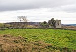 Upload another image | |||
| Manse Cottage, Glenshee | 56°48′52″N 3°27′38″W / 56.814492°N 3.460562°W / 56.814492; -3.460562 (Manse Cottage, Glenshee) | Category C(S) | 11487 |  Upload another image | |||
| Kirkmichael Bridge Over River Ardle | 56°43′24″N 3°30′18″W / 56.723388°N 3.505008°W / 56.723388; -3.505008 (Kirkmichael Bridge Over River Ardle) | Category B | 11472 | Upload Photo | |||
| Mill Of Dunie | 56°42′53″N 3°29′22″W / 56.714634°N 3.489545°W / 56.714634; -3.489545 (Mill Of Dunie) | Category C(S) | 11475 | Upload Photo | |||
| Cray Church Of Scotland (Former Free Church) | 56°45′23″N 3°23′47″W / 56.756503°N 3.396335°W / 56.756503; -3.396335 (Cray Church Of Scotland (Former Free Church)) | Category C(S) | 11484 | 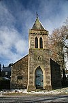 Upload another image | |||
| Dalnaglar Castle | 56°45′58″N 3°23′56″W / 56.766241°N 3.398889°W / 56.766241; -3.398889 (Dalnaglar Castle) | Category C(S) | 11485 | 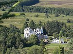 Upload another image | |||
| Kirkmichael And Straloch Churchyard | 56°43′24″N 3°30′13″W / 56.723261°N 3.503614°W / 56.723261; -3.503614 (Kirkmichael And Straloch Churchyard) | Category C(S) | 11470 | Upload Photo | |||
| Balvarran House | 56°44′26″N 3°30′58″W / 56.740649°N 3.516047°W / 56.740649; -3.516047 (Balvarran House) | Category B | 11480 | Upload Photo | |||
| Milton Limekiln | 56°43′09″N 3°29′21″W / 56.71913°N 3.489167°W / 56.71913; -3.489167 (Milton Limekiln) | Category C(S) | 11479 | Upload Photo | |||
| Kirkmichael And Straloch Parish Church | 56°43′24″N 3°30′14″W / 56.723392°N 3.503897°W / 56.723392; -3.503897 (Kirkmichael And Straloch Parish Church) | Category B | 11515 | Upload Photo | |||
| Glenshee Bridge Over Shee Water | 56°48′50″N 3°27′40″W / 56.813919°N 3.461146°W / 56.813919; -3.461146 (Glenshee Bridge Over Shee Water) | Category B | 11489 | Upload Photo | |||
| Glenshee Church Of Scotland | 56°48′53″N 3°27′41″W / 56.814643°N 3.461403°W / 56.814643; -3.461403 (Glenshee Church Of Scotland) | Category B | 11486 |  Upload another image | |||
| Old Spittal | 56°48′59″N 3°27′24″W / 56.816262°N 3.456634°W / 56.816262; -3.456634 (Old Spittal) | Category C(S) | 11488 | Upload Photo |
Key
The scheme for classifying buildings in Scotland is:
- Category A: "buildings of national or international importance, either architectural or historic; or fine, little-altered examples of some particular period, style or building type."[1]
- Category B: "buildings of regional or more than local importance; or major examples of some particular period, style or building type, which may have been altered."[1]
- Category C: "buildings of local importance; lesser examples of any period, style, or building type, as originally constructed or moderately altered; and simple traditional buildings which group well with other listed buildings."[1]
In March 2016 there were 47,288 listed buildings in Scotland. Of these, 8% were Category A, and 50% were Category B, with the remaining 42% being Category C.[2]
Notes
- ^ Sometimes known as OSGB36, the grid reference (where provided) is based on the British national grid reference system used by the Ordnance Survey.
• "Guide to National Grid". Ordnance Survey. Retrieved 12 December 2007.
• "Get-a-map". Ordnance Survey. Retrieved 17 December 2007. - ^ Historic Environment Scotland assign a unique alphanumeric identifier to each designated site in Scotland, for listed buildings this always begins with "LB", for example "LB12345".
References
- All entries, addresses and coordinates are based on data from Historic Scotland. This data falls under the Open Government Licence
- ^ a b c "What is Listing?". Historic Environment Scotland. Retrieved 29 May 2018.
- ^ Scotland's Historic Environment Audit 2016 (PDF). Historic Environment Scotland and the Built Environment Forum Scotland. pp. 15–16. Retrieved 29 May 2018.
- v
- t
- e
- Aberdalgie
- Aberfeldy
- Abernethy
- Abernyte
- Alyth
- Ardoch
- Arngask
- Auchterarder
- Auchtergaven
- Bendochy
- Blackford
- Blair Atholl
- Blairgowrie and Rattray
- Blairgowrie
- Caputh
- Cargill
- Cleish
- Clunie
- Collace
- Comrie
- Coupar Angus
- Crieff
- Dron
- Dull
- Dunbarney
- Dunkeld and Dowally
- Dunning
- Errol
- Findo Gask
- Forgandenny
- Forteviot
- Fortingall
- Fossoway
- Fowlis Wester
- Glendevon
- Inchture
- Kenmore
- Kettins
- Kilspindie
- Kinclaven
- Kinfauns
- Kinloch
- Kinnaird
- Kinnoull
- Kinross
- Kirkmichael
- Lethendy
- Liff and Benvie
- Little Dunkeld
- Logiealmond
- Logierait
- Longforgan
- Madderty
- Meigle
- Methven
- Moneydie
- Monzievaird and Strowan
- Moulin
- Muckhart
- Muthill
- Orwell
- Perth
- Pitlochry
- Portmoak
- Rattray
- Redgorton
- Rhynd
- Scone
- St Madoes
- St Martins
- Tibbermore
- Trinity Gask
- Weem


