National Register of Historic Places listings in Chickasaw County, Mississippi

This is a list of the National Register of Historic Places listings in Chickasaw County, Mississippi.
This is intended to be a complete list of the properties and districts on the National Register of Historic Places in Chickasaw County, Mississippi, United States. Latitude and longitude coordinates are provided for many National Register properties and districts; these locations may be seen together in a map.[1]
There are 10 properties and districts listed on the National Register in the county.
This National Park Service list is complete through NPS recent listings posted September 5, 2024.[2]
Map all coordinates using OpenStreetMap
Download coordinates as:
- KML
- GPX (all coordinates)
- GPX (primary coordinates)
- GPX (secondary coordinates)
Current listings
| [3] | Name on the Register | Image | Date listed[4] | Location | City or town | Description |
|---|---|---|---|---|---|---|
| 1 | Bynum Mound and Village Site (22CS501) |  | July 16, 1989 (#89000783) | Mile 232.4 on the Natchez Trace Parkway[5] 33°53′53″N 88°56′53″W / 33.8981°N 88.9481°W / 33.8981; -88.9481 (Bynum Mound and Village Site (22CS501)) | Houston | |
| 2 | Elliott-Donaldson House |  | September 15, 1980 (#80002203) | 109 N. Church Street 34°00′24″N 88°45′24″W / 34.006667°N 88.756667°W / 34.006667; -88.756667 (Elliott-Donaldson House) | Okolona | Constructed c. 1850 |
| 3 | Houston Carnegie Library |  | December 22, 1978 (#78001593) | 105 W. Madison 33°53′47″N 89°00′03″W / 33.896389°N 89.000833°W / 33.896389; -89.000833 (Houston Carnegie Library) | Houston | Constructed in 1909 |
| 4 | Houston Historic District |  | May 14, 2013 (#13000300) | Depot, Monroe, Madison & Pontotoc Sts. 33°53′49″N 89°00′00″W / 33.897°N 89.000°W / 33.897; -89.000 (Houston Historic District) | Houston | |
| 5 | Judge Bates House |  | May 6, 1982 (#82003097) | 330 South Monroe Street 33°53′46″N 89°00′01″W / 33.896111°N 89.000278°W / 33.896111; -89.000278 (Judge Bates House) | Houston | Constructed c. 1845 |
| 6 | Merchants and Farmers Bank Building | Upload image | May 14, 1987 (#87000733) | 423 Main Street 34°00′15″N 88°44′56″W / 34.004167°N 88.748889°W / 34.004167; -88.748889 (Merchants and Farmers Bank Building) | Okolona | Demolished |
| 7 | Okolona College |  | August 9, 2002 (#02000853) | 654 MS-245 34°01′04″N 88°45′27″W / 34.017778°N 88.7575°W / 34.017778; -88.7575 (Okolona College) | Okolona | A former college for African-Americans |
| 8 | Okolona Historic District | 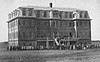 | February 5, 2002 (#01001561) | Roughly bounded by Fleming, Monroe, Buchanan, and Washington Sts. 34°00′18″N 88°45′03″W / 34.005°N 88.750833°W / 34.005; -88.750833 (Okolona Historic District) | Okolona | |
| 9 | Owl Creek Site |  | August 1, 1975 (#75001042) | 1184 CR-413 34°03′23″N 88°55′28″W / 34.056389°N 88.924444°W / 34.056389; -88.924444 (Owl Creek Site) | Old Houlka | |
| 10 | Thelma Mound Archaeological Site |  | November 3, 1994 (#94001222) | Address restricted[6] | Houston |
See also
Wikimedia Commons has media related to National Register of Historic Places in Chickasaw County, Mississippi.
- List of National Historic Landmarks in Mississippi
- National Register of Historic Places listings in Mississippi
References
- ^ The latitude and longitude information provided in this table was derived originally from the National Register Information System, which has been found to be fairly accurate for about 99% of listings. Some locations in this table may have been corrected to current GPS standards.
- ^ National Park Service, United States Department of the Interior, "National Register of Historic Places: Weekly List Actions", retrieved September 5, 2024.
- ^ Numbers represent an alphabetical ordering by significant words. Various colorings, defined here, differentiate National Historic Landmarks and historic districts from other NRHP buildings, structures, sites or objects.
- ^ The eight-digit number below each date is the number assigned to each location in the National Register Information System database, which can be viewed by clicking the number.
- ^ Location derived from this National Park Service webpage
- ^ Federal and state laws and practices restrict general public access to information regarding the specific location of this resource. In some cases, this is to protect archeological sites from vandalism, while in other cases it is restricted at the request of the owner. See: Knoerl, John; Miller, Diane; Shrimpton, Rebecca H. (1990), Guidelines for Restricting Information about Historic and Prehistoric Resources, National Register Bulletin, National Park Service, U.S. Department of the Interior, OCLC 20706997.
- v
- t
- e
by county
- Adams
- Alcorn
- Amite
- Attala
- Benton
- Bolivar
- Calhoun
- Carroll
- Chickasaw
- Choctaw
- Claiborne
- Clarke
- Clay
- Coahoma
- Copiah
- Covington
- DeSoto
- Forrest
- Franklin
- George
- Greene
- Grenada
- Hancock
- Harrison
- Hinds
- Holmes
- Humphreys
- Issaquena
- Itawamba
- Jackson
- Jasper
- Jefferson
- Jefferson Davis
- Jones
- Kemper
- Lafayette
- Lamar
- Lauderdale
- Lawrence
- Leake
- Lee
- Leflore
- Lincoln
- Lowndes
- Madison
- Marion
- Marshall
- Monroe
- Montgomery
- Neshoba
- Newton
- Noxubee
- Oktibbeha
- Panola
- Pearl River
- Perry
- Pike
- Pontotoc
- Prentiss
- Quitman
- Rankin
- Scott
- Sharkey
- Simpson
- Smith
- Stone
- Sunflower
- Tallahatchie
- Tate
- Tippah
- Tishomingo
- Tunica
- Union
- Walthall
- Warren
- Washington
- Wayne
- Webster
- Wilkinson
- Winston
- Yalobusha
- Yazoo


