National Register of Historic Places listings in Lafayette County, Mississippi

This is a list of the National Register of Historic Places listings in Lafayette County, Mississippi.
This is intended to be a complete list of the properties and districts on the National Register of Historic Places in Lafayette County, Mississippi, United States. Latitude and longitude coordinates are provided for many National Register properties and districts; these locations may be seen together in a map.[1]
There are 17 properties and districts listed on the National Register in the county, including 4 National Historic Landmarks.
This National Park Service list is complete through NPS recent listings posted September 5, 2024.[2]
Map all coordinates using OpenStreetMap
Download coordinates as:
- KML
- GPX (all coordinates)
- GPX (primary coordinates)
- GPX (secondary coordinates)
Current listings
| [3] | Name on the Register[4] | Image | Date listed[5] | Location | City or town | Description |
|---|---|---|---|---|---|---|
| 1 | Abbeville Colored School | Upload image | February 22, 2021 (#100006175) | West side of Cty. Rd, 115 Coordinates missing | Abbeville | |
| 2 | Ammadelle | 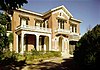 | May 30, 1974 (#74001064) | 637 N. Lamar St. 34°22′20″N 89°31′11″W / 34.3722°N 89.5197°W / 34.3722; -89.5197 (Ammadelle) | Oxford | |
| 3 | Avent Acres Neighborhood Historic District | Upload image | July 14, 2020 (#100004508) | Approx. Lamar Ave. and Oxford Apartments; Parcels 135L-21-059.00, 135L-21-062.00, 35L-21-078.00 & 35L-21-078.00; Douglas Dr.;and Sisk Ave. 34°22′23″N 89°30′44″W / 34.3731°N 89.5121°W / 34.3731; -89.5121 (Avent Acres Neighborhood Historic District) | Oxford | |
| 4 | Barnard Observatory |  | December 8, 1978 (#78001607) | University of Mississippi campus 34°21′58″N 89°32′04″W / 34.3661°N 89.5344°W / 34.3661; -89.5344 (Barnard Observatory) | Oxford | |
| 5 | College Church |  | November 13, 1979 (#79001324) | College Hill Rd. 34°25′23″N 89°34′06″W / 34.4231°N 89.5683°W / 34.4231; -89.5683 (College Church) | College Hill | Destroyed by a fire on August 13, 2022.[6] |
| 6 | William Faulkner House |  | May 23, 1968 (#68000028) | Old Taylor Rd. 34°21′30″N 89°31′32″W / 34.3583°N 89.5256°W / 34.3583; -89.5256 (William Faulkner House) | Oxford | |
| 7 | Hopewell Presbyterian Church |  | July 15, 1999 (#99000837) | 2070 Mississippi Highway 10 34°23′37″N 89°24′41″W / 34.3936°N 89.4114°W / 34.3936; -89.4114 (Hopewell Presbyterian Church) | Oxford | |
| 8 | Isom Place | 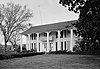 | April 2, 1980 (#80002256) | 1003 Jefferson Ave. 34°22′09″N 89°31′10″W / 34.3692°N 89.5194°W / 34.3692; -89.5194 (Isom Place) | Oxford | |
| 9 | Lafayette County Courthouse |  | September 23, 1977 (#77000791) | Courthouse Sq. 34°22′00″N 89°31′06″W / 34.3667°N 89.5183°W / 34.3667; -89.5183 (Lafayette County Courthouse) | Oxford | |
| 10 | Lucius Quintus Cincinnatus Lamar House |  | May 15, 1975 (#75001048) | 616 N. 14th St. 34°22′20″N 89°30′55″W / 34.3722°N 89.5153°W / 34.3722; -89.5153 (Lucius Quintus Cincinnatus Lamar House) | Oxford | |
| 11 | Lyceum-The Circle Historic District |  | October 6, 2008 (#08001092) | University Circle at the University of Mississippi 34°21′56″N 89°32′07″W / 34.3655°N 89.5352°W / 34.3655; -89.5352 (Lyceum-The Circle Historic District) | Oxford | |
| 12 | North Lamar Historic District |  | November 14, 2007 (#07001181) | Roughly bounded by N. 11th, Price, N. 16th, and Van Buren Sts. 34°22′07″N 89°31′06″W / 34.3686°N 89.5182°W / 34.3686; -89.5182 (North Lamar Historic District) | Oxford | |
| 13 | Oxford Courthouse Square Historic District |  | April 2, 1980 (#80002257) | S. Lamar Boulevard and Jackson and Van Buren Aves. 34°21′58″N 89°31′04″W / 34.3661°N 89.5178°W / 34.3661; -89.5178 (Oxford Courthouse Square Historic District) | Oxford | |
| 14 | Sand Spring Presbyterian Church | 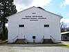 | February 25, 1993 (#93000083) | Junction of County Roads 354 and 399 in Orwood, northwest of Water Valley 34°15′24″N 89°42′55″W / 34.2567°N 89.7153°W / 34.2567; -89.7153 (Sand Spring Presbyterian Church) | Water Valley | |
| 15 | St. Peter's Episcopal Church |  | July 24, 1975 (#75001049) | 113 S. 9th St. 34°22′00″N 89°31′13″W / 34.3667°N 89.5203°W / 34.3667; -89.5203 (St. Peter's Episcopal Church) | Oxford | |
| 16 | South Lamar Historic District |  | March 10, 2009 (#09000112) | S. Lamar Boulevard and University Ave. 34°21′46″N 89°31′10″W / 34.3627°N 89.5195°W / 34.3627; -89.5195 (South Lamar Historic District) | Oxford | |
| 17 | George Wright Young House | 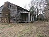 | November 14, 2007 (#07001182) | 100 County Road 233 34°23′22″N 89°23′39″W / 34.389444°N 89.394167°W / 34.389444; -89.394167 (George Wright Young House) | Oxford |
See also
Wikimedia Commons has media related to National Register of Historic Places in Lafayette County, Mississippi.
- List of National Historic Landmarks in Mississippi
- National Register of Historic Places listings in Mississippi
References
- ^ The latitude and longitude information provided in this table was derived originally from the National Register Information System, which has been found to be fairly accurate for about 99% of listings. Some locations in this table may have been corrected to current GPS standards.
- ^ National Park Service, United States Department of the Interior, "National Register of Historic Places: Weekly List Actions", retrieved September 5, 2024.
- ^ Numbers represent an alphabetical ordering by significant words. Various colorings, defined here, differentiate National Historic Landmarks and historic districts from other NRHP buildings, structures, sites or objects.
- ^ "National Register Information System". National Register of Historic Places. National Park Service. March 13, 2009.
- ^ The eight-digit number below each date is the number assigned to each location in the National Register Information System database, which can be viewed by clicking the number.
- ^ Oxford Eagle
- v
- t
- e
by county
- Adams
- Alcorn
- Amite
- Attala
- Benton
- Bolivar
- Calhoun
- Carroll
- Chickasaw
- Choctaw
- Claiborne
- Clarke
- Clay
- Coahoma
- Copiah
- Covington
- DeSoto
- Forrest
- Franklin
- George
- Greene
- Grenada
- Hancock
- Harrison
- Hinds
- Holmes
- Humphreys
- Issaquena
- Itawamba
- Jackson
- Jasper
- Jefferson
- Jefferson Davis
- Jones
- Kemper
- Lafayette
- Lamar
- Lauderdale
- Lawrence
- Leake
- Lee
- Leflore
- Lincoln
- Lowndes
- Madison
- Marion
- Marshall
- Monroe
- Montgomery
- Neshoba
- Newton
- Noxubee
- Oktibbeha
- Panola
- Pearl River
- Perry
- Pike
- Pontotoc
- Prentiss
- Quitman
- Rankin
- Scott
- Sharkey
- Simpson
- Smith
- Stone
- Sunflower
- Tallahatchie
- Tate
- Tippah
- Tishomingo
- Tunica
- Union
- Walthall
- Warren
- Washington
- Wayne
- Webster
- Wilkinson
- Winston
- Yalobusha
- Yazoo

Municipalities and communities of Lafayette County, Mississippi, United States | ||
|---|---|---|
County seat: Oxford | ||
| City |  | |
| Towns | ||
| CDPs | ||
| Other communities | ||
| Ghost town | ||
| ||


