National Register of Historic Places listings in Hancock County, Mississippi

This is a list of the National Register of Historic Places listings in Hancock County, Mississippi.
This is intended to be a complete list of the properties and districts on the National Register of Historic Places in Hancock County, Mississippi, United States. Latitude and longitude coordinates are provided for many National Register properties and districts; these locations may be seen together in a map.[1]
There are 18 properties and districts listed on the National Register in the county, including 1 National Historic Landmark. Another 4 properties were once listed but have been removed.
This National Park Service list is complete through NPS recent listings posted September 5, 2024.[2]
Map all coordinates using OpenStreetMap
Download coordinates as:
- KML
- GPX (all coordinates)
- GPX (primary coordinates)
- GPX (secondary coordinates)
Current listings
| [3] | Name on the Register[4] | Image | Date listed[5] | Location | City or town | Description |
|---|---|---|---|---|---|---|
| 1 | Beach Boulevard Historic District | Upload image | November 25, 1980 (#80002239) | Roughly bounded by Beach Boulevard, Necaise Ave., Seminary Dr., and 2nd and 3rd Sts. 30°18′24″N 89°20′30″W / 30.306667°N 89.341667°W / 30.306667; -89.341667 (Beach Boulevard Historic District) | Bay St. Louis | |
| 2 | Building at 242 St. Charles Street |  | November 25, 1980 (#80002240) | 242 St. Charles St. 30°18′12″N 89°20′35″W / 30.30322°N 89.34305°W / 30.30322; -89.34305 (Building at 242 St. Charles Street) | Bay St. Louis | |
| 3 | Claiborne Site (22Ha501) | Upload image | November 12, 1982 (#82000574) | Address restricted[6] | Pearlington | |
| 4 | House at 5098 MS 604 | Upload image | January 19, 2016 (#15000985) | 5098 MS 604 30°14′34″N 89°36′34″W / 30.242693°N 89.609546°W / 30.242693; -89.609546 (House at 5098 MS 604) | Pearlington | |
| 5 | Jackson Landing Site | Upload image | July 27, 1973 (#73001009) | Address restricted[6] | Pearlington | |
| 6 | Main Street Historic District | 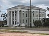 | November 25, 1980 (#80002241) | Main St. 30°18′56″N 89°20′37″W / 30.315556°N 89.343611°W / 30.315556; -89.343611 (Main Street Historic District) | Bay St. Louis | |
| 7 | William and Mary McGee House |  | October 4, 2021 (#100006893) | 16634 Whites Rd. 30°15′14″N 89°36′39″W / 30.2540°N 89.6109°W / 30.2540; -89.6109 (William and Mary McGee House) | Pearlington | |
| 8 | Nugent Site (22HA592) | Upload image | April 13, 1988 (#88000307) | Address restricted[6] | Kiln | |
| 9 | Old Bay St. Louis Historic District | Upload image | July 8, 2010 (#10000441) | Roughly bounded by Beach Boulevard and 3rd St. on the east, Breath Ln. and Highway 90 on the north, Seminary Dr., St. Francis St., and Old Spanish Trail on the west, and Carre Ct., Washington St., and Bookter St. on the south 30°18′32″N 89°19′48″W / 30.308889°N 89.33°W / 30.308889; -89.33 (Old Bay St. Louis Historic District) | Bay St. Louis | |
| 10 | Rocket Propulsion Test Complex |  | October 3, 1985 (#85002805) | National Space Technology Laboratories 30°21′56″N 89°35′13″W / 30.365556°N 89.586944°W / 30.365556; -89.586944 (Rocket Propulsion Test Complex) | Bay St. Louis | |
| 11 | SJ Mound (22HA594) | Upload image | April 13, 1988 (#88000304) | Address restricted[6] | Pearlington | |
| 12 | Sycamore Street Historic District | Upload image | November 25, 1980 (#80002242) | Sycamore St. 30°18′31″N 89°20′39″W / 30.308611°N 89.344167°W / 30.308611; -89.344167 (Sycamore Street Historic District) | Bay St. Louis | |
| 13 | Three Sisters Shell Midden (22-Ha-596) | Upload image | July 28, 1988 (#88001138) | Address restricted[6] | Pearlington | |
| 14 | Up the Tree Shell Midden (22HA595) | Upload image | April 13, 1988 (#88000306) | Address restricted[6] | Pearlington | |
| 15 | Washington Street Historic District | Upload image | November 25, 1980 (#80002243) | Washington St. 30°18′24″N 89°20′30″W / 30.306667°N 89.341667°W / 30.306667; -89.341667 (Washington Street Historic District) | Bay St. Louis | |
| 16 | Waveland Elementary School |  | June 2, 2014 (#14000273) | 335 Coleman Ave. 30°17′11″N 89°22′28″W / 30.286299°N 89.374382°W / 30.286299; -89.374382 (Waveland Elementary School) | Waveland | Now houses the Ground Zero Hurricane Museum |
| 17 | Webb School/Gulf Coast Community Action Agency |  | November 21, 1986 (#86003554) | 300 3rd St. 30°18′16″N 89°20′19″W / 30.3044°N 89.33853°W / 30.3044; -89.33853 (Webb School/Gulf Coast Community Action Agency) | Bay St. Louis | |
| 18 | Williams Site (22-Ha-585) | Upload image | July 28, 1988 (#88001137) | Address restricted[6] | Pearlington |
Former listings
| [3] | Name on the Register | Image | Date listed | Date removed | Location | City or town | Description |
|---|---|---|---|---|---|---|---|
| 1 | Glen Oaks | Upload image | November 21, 1986 (#86003271) | July 16, 2008 | 806 North Beach Boulevard | Bay St. Louis | Also known as the Kimbrough House. Destroyed by Hurricane Katrina in 2005.[7] |
| 2 | Onward Oaks | Upload image | November 1, 1996 (#96001265) | July 16, 2008 | 972 South Beach Boulevard | Bay St. Louis | Suffered major damage from Hurricane Camille in 1969. Destroyed by Hurricane Katrina in 2005.[8] |
| 3 | Taylor House | Upload image | November 21, 1986 (#86003273) | July 16, 2008 | 808 North Beach Boulevard | Bay St. Louis | Destroyed by Hurricane Katrina in 2005.[9] |
| 4 | Taylor School | Upload image | January 15, 1987 (#87000209) | July 16, 2008 | 116 Leonard Street | Bay St. Louis | Destroyed by Hurricane Katrina in 2005.[10] |
See also
Wikimedia Commons has media related to National Register of Historic Places in Hancock County, Mississippi.
- List of National Historic Landmarks in Mississippi
- National Register of Historic Places listings in Mississippi
References
- ^ The latitude and longitude information provided in this table was derived originally from the National Register Information System, which has been found to be fairly accurate for about 99% of listings. Some locations in this table may have been corrected to current GPS standards.
- ^ National Park Service, United States Department of the Interior, "National Register of Historic Places: Weekly List Actions", retrieved September 5, 2024.
- ^ a b Numbers represent an alphabetical ordering by significant words. Various colorings, defined here, differentiate National Historic Landmarks and historic districts from other NRHP buildings, structures, sites or objects.
- ^ "National Register Information System". National Register of Historic Places. National Park Service. March 13, 2009.
- ^ The eight-digit number below each date is the number assigned to each location in the National Register Information System database, which can be viewed by clicking the number.
- ^ a b c d e f g Federal and state laws and practices restrict general public access to information regarding the specific location of this resource. In some cases, this is to protect archeological sites from vandalism, while in other cases it is restricted at the request of the owner. See: Knoerl, John; Miller, Diane; Shrimpton, Rebecca H. (1990), Guidelines for Restricting Information about Historic and Prehistoric Resources, National Register Bulletin, National Park Service, U.S. Department of the Interior, OCLC 20706997.
- ^ "MDAH Glen Oaks".
- ^ "MDAH Onward Oaks".
- ^ "MDAH Taylor House".
- ^ "MDAH Taylor School".
- v
- t
- e
by county
- Adams
- Alcorn
- Amite
- Attala
- Benton
- Bolivar
- Calhoun
- Carroll
- Chickasaw
- Choctaw
- Claiborne
- Clarke
- Clay
- Coahoma
- Copiah
- Covington
- DeSoto
- Forrest
- Franklin
- George
- Greene
- Grenada
- Hancock
- Harrison
- Hinds
- Holmes
- Humphreys
- Issaquena
- Itawamba
- Jackson
- Jasper
- Jefferson
- Jefferson Davis
- Jones
- Kemper
- Lafayette
- Lamar
- Lauderdale
- Lawrence
- Leake
- Lee
- Leflore
- Lincoln
- Lowndes
- Madison
- Marion
- Marshall
- Monroe
- Montgomery
- Neshoba
- Newton
- Noxubee
- Oktibbeha
- Panola
- Pearl River
- Perry
- Pike
- Pontotoc
- Prentiss
- Quitman
- Rankin
- Scott
- Sharkey
- Simpson
- Smith
- Stone
- Sunflower
- Tallahatchie
- Tate
- Tippah
- Tishomingo
- Tunica
- Union
- Walthall
- Warren
- Washington
- Wayne
- Webster
- Wilkinson
- Winston
- Yalobusha
- Yazoo

Municipalities and communities of Hancock County, Mississippi, United States | ||
|---|---|---|
County seat: Bay St. Louis | ||
| Cities |  | |
| CDPs | ||
| Other unincorporated communities | ||
| Ghost towns | ||
| ||


