National Register of Historic Places listings in Oktibbeha County, Mississippi
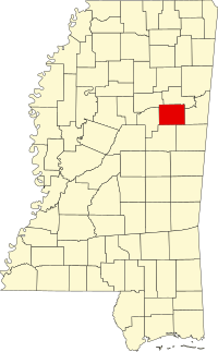
This is a list of the National Register of Historic Places listings in Oktibbeha County, Mississippi.
This is intended to be a complete list of the properties and districts on the National Register of Historic Places in Oktibbeha County, Mississippi, United States. Latitude and longitude coordinates are provided for many National Register properties and districts; these locations may be seen together in a map.[1]
There are 25 properties and districts listed on the National Register in the county.
This National Park Service list is complete through NPS recent listings posted September 5, 2024.[2]
Map all coordinates using OpenStreetMap
Download coordinates as:
- KML
- GPX (all coordinates)
- GPX (primary coordinates)
- GPX (secondary coordinates)
Current listings
| [3] | Name on the Register[4] | Image | Date listed[5] | Location | City or town | Description |
|---|---|---|---|---|---|---|
| 1 | Bardwell House | Upload image | July 16, 1992 (#92000890) | 309 Blackjack Road 33°26′53″N 88°46′56″W / 33.448056°N 88.782222°W / 33.448056; -88.782222 (Bardwell House) | Starkville | Demolished |
| 2 | Bell House | Upload image | October 29, 1992 (#92001480) | 1280 Mississippi Highway 25, S. 33°26′11″N 88°49′06″W / 33.436389°N 88.818333°W / 33.436389; -88.818333 (Bell House) | Starkville | |
| 3 | Thomas Battle Carroll House |  | May 1, 1991 (#91000531) | 304 S. Jackson St. 33°27′36″N 88°48′51″W / 33.46°N 88.814167°W / 33.46; -88.814167 (Thomas Battle Carroll House) | Starkville | |
| 4 | The Cedars |  | October 10, 1985 (#85003003) | 607 Old West Point Rd. 33°28′31″N 88°48′04″W / 33.475278°N 88.801111°W / 33.475278; -88.801111 (The Cedars) | Starkville | |
| 5 | Downtown Starkville Historic District | Upload image | July 25, 2012 (#12000433) | Roughly bounded by Jefferson, N. Montgomery, & Yeates Sts., & railroad 33°27′48″N 88°48′52″W / 33.463311°N 88.81453°W / 33.463311; -88.81453 (Downtown Starkville Historic District) | Starkville | |
| 6 | C. E. Gay House |  | January 3, 1991 (#90002108) | 110 E. Gillespie St. 33°27′28″N 88°48′55″W / 33.457778°N 88.815278°W / 33.457778; -88.815278 (C. E. Gay House) | Starkville | |
| 7 | Gillespie-Jackson House | Upload image | November 6, 1986 (#86003127) | 701 Louisville 33°27′13″N 88°49′17″W / 33.453611°N 88.821389°W / 33.453611; -88.821389 (Gillespie-Jackson House) | Starkville | Demolished |
| 8 | Greensboro Street Historic District | Upload image | June 14, 1982 (#82003112) | Greensboro St.; also Ernest Jones Jr. Dr., Greensboro St., Louisville St., Main St., W., Raymond St., and Yeates St. 33°27′42″N 88°49′29″W / 33.461667°N 88.824722°W / 33.461667; -88.824722 (Greensboro Street Historic District) | Starkville | Second set of boundaries represents a boundary increase of July 10, 2008 |
| 9 | Herman Mound and Village Site | Upload image | March 17, 1993 (#93000137) | Address restricted[6] | Starkville | |
| 10 | Hotel Chester |  | January 18, 1985 (#85000099) | 217-223 E. Main St. 33°27′50″N 88°48′51″W / 33.463889°N 88.814167°W / 33.463889; -88.814167 (Hotel Chester) | Starkville | |
| 11 | Lampkin-Owens House |  | November 24, 1980 (#80002298) | 117 N. Montgomery St. 33°27′56″N 88°48′38″W / 33.465556°N 88.810556°W / 33.465556; -88.810556 (Lampkin-Owens House) | Starkville | |
| 12 | Lyon's Bluff Site | Upload image | April 22, 1976 (#76001105) | Address restricted[6] | Starkville | |
| 13 | Magruder-Newsom House | Upload image | August 30, 1984 (#84002284) | 306 S. Jackson St. 33°27′36″N 88°48′51″W / 33.46°N 88.814167°W / 33.46; -88.814167 (Magruder-Newsom House) | Starkville | |
| 14 | Meadow Woods Plantation House | Upload image | September 7, 2001 (#01000946) | 2479 Oktoc Rd. 33°22′04″N 88°45′43″W / 33.367778°N 88.761944°W / 33.367778; -88.761944 (Meadow Woods Plantation House) | Starkville | |
| 15 | Montgomery Hall | 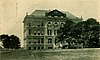 | March 26, 1975 (#75001054) | Mississippi State University campus 33°27′13″N 88°47′29″W / 33.453611°N 88.791389°W / 33.453611; -88.791389 (Montgomery Hall) | Starkville | Constructed 1902-03 using Beaux-Arts architectural style[7] |
| 16 | Nash Street Historic District | Upload image | June 24, 1993 (#93000572) | 525 University Dr. and 101-117 N. Nash St. 33°27′47″N 88°48′14″W / 33.463056°N 88.803889°W / 33.463056; -88.803889 (Nash Street Historic District) | Starkville | |
| 17 | Odd Fellows Cemetery | 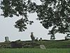 | July 24, 1990 (#90001064) | Junction of U.S. Route 82 and Henderson St. 33°28′00″N 88°49′15″W / 33.466667°N 88.820833°W / 33.466667; -88.820833 (Odd Fellows Cemetery) | Starkville | |
| 18 | Oktibbeha Gardens Subdivision Historic District | Upload image | September 28, 2017 (#100001682) | Roughly bounded by Critz & N. Montgomery Sts., Old West Point Rd. & Dr. Martin Luther King Jr. Dr. E. 33°28′08″N 88°48′29″W / 33.468971°N 88.808108°W / 33.468971; -88.808108 (Oktibbeha Gardens Subdivision Historic District) | Starkville | |
| 19 | Dossey A. Outlaw Plantation |  | April 11, 2002 (#02000354) | 6114 Oktoc Rd. 33°23′07″N 88°46′27″W / 33.385278°N 88.774167°W / 33.385278; -88.774167 (Dossey A. Outlaw Plantation) | Starkville | |
| 20 | Overstreet School Historic District | Upload image | October 23, 1992 (#92001398) | Roughly bounded by Hogan, Montgomery, Gillespie, Jackson, Wood, and Washington Sts. and the Illinois Central railroad tracks 33°27′34″N 88°48′48″W / 33.459444°N 88.813333°W / 33.459444; -88.813333 (Overstreet School Historic District) | Starkville | |
| 21 | Emma and Ed Rogers House |  | September 28, 2017 (#100001684) | 1245 Longview Rd. 33°24′16″N 88°51′29″W / 33.404444°N 88.858056°W / 33.404444; -88.858056 (Emma and Ed Rogers House) | Starkville | |
| 22 | Starkville Colored Cemetery |  | June 2, 2014 (#14000277) | N. side of University Dr., W. of N. Nash & E. of Hartness Sts. 33°27′46″N 88°48′25″W / 33.462908°N 88.806842°W / 33.462908; -88.806842 (Starkville Colored Cemetery) | Starkville | |
| 23 | John M. Stone Cotton Mill |  | April 29, 1975 (#75001055) | 600 Russell St. 33°27′26″N 88°48′09″W / 33.457222°N 88.8025°W / 33.457222; -88.8025 (John M. Stone Cotton Mill) | Starkville | |
| 24 | Textile Building |  | May 12, 1975 (#75001056) | South of Starkville on the Mississippi State University campus 33°27′08″N 88°47′30″W / 33.452222°N 88.791667°W / 33.452222; -88.791667 (Textile Building) | Starkville | Constructed in 1900 using Italianate, Mission & Romanesque architectural styles. Oldest academic building on the Mississippi State University campus.[8] |
| 25 | Walker-Critz House |  | March 22, 1989 (#89000171) | 414 Chapin St. 33°28′01″N 88°48′29″W / 33.466944°N 88.808056°W / 33.466944; -88.808056 (Walker-Critz House) | Starkville |
See also
Wikimedia Commons has media related to National Register of Historic Places in Oktibbeha County, Mississippi.
- List of National Historic Landmarks in Mississippi
- National Register of Historic Places listings in Mississippi
References
- ^ The latitude and longitude information provided in this table was derived originally from the National Register Information System, which has been found to be fairly accurate for about 99% of listings. Some locations in this table may have been corrected to current GPS standards.
- ^ National Park Service, United States Department of the Interior, "National Register of Historic Places: Weekly List Actions", retrieved September 5, 2024.
- ^ Numbers represent an alphabetical ordering by significant words. Various colorings, defined here, differentiate National Historic Landmarks and historic districts from other NRHP buildings, structures, sites or objects.
- ^ "National Register Information System". National Register of Historic Places. National Park Service. March 13, 2009.
- ^ The eight-digit number below each date is the number assigned to each location in the National Register Information System database, which can be viewed by clicking the number.
- ^ a b Federal and state laws and practices restrict general public access to information regarding the specific location of this resource. In some cases, this is to protect archeological sites from vandalism, while in other cases it is restricted at the request of the owner. See: Knoerl, John; Miller, Diane; Shrimpton, Rebecca H. (1990), Guidelines for Restricting Information about Historic and Prehistoric Resources, National Register Bulletin, National Park Service, U.S. Department of the Interior, OCLC 20706997.
- ^ Montgomery Hall
- ^ Textile Building
- v
- t
- e
by county
- Adams
- Alcorn
- Amite
- Attala
- Benton
- Bolivar
- Calhoun
- Carroll
- Chickasaw
- Choctaw
- Claiborne
- Clarke
- Clay
- Coahoma
- Copiah
- Covington
- DeSoto
- Forrest
- Franklin
- George
- Greene
- Grenada
- Hancock
- Harrison
- Hinds
- Holmes
- Humphreys
- Issaquena
- Itawamba
- Jackson
- Jasper
- Jefferson
- Jefferson Davis
- Jones
- Kemper
- Lafayette
- Lamar
- Lauderdale
- Lawrence
- Leake
- Lee
- Leflore
- Lincoln
- Lowndes
- Madison
- Marion
- Marshall
- Monroe
- Montgomery
- Neshoba
- Newton
- Noxubee
- Oktibbeha
- Panola
- Pearl River
- Perry
- Pike
- Pontotoc
- Prentiss
- Quitman
- Rankin
- Scott
- Sharkey
- Simpson
- Smith
- Stone
- Sunflower
- Tallahatchie
- Tate
- Tippah
- Tishomingo
- Tunica
- Union
- Walthall
- Warren
- Washington
- Wayne
- Webster
- Wilkinson
- Winston
- Yalobusha
- Yazoo

Municipalities and communities of Oktibbeha County, Mississippi, United States | ||
|---|---|---|
County seat: Starkville | ||
| City |  | |
| Towns | ||
| CDPs | ||
| Other communities | ||
| Ghost town | ||
| Footnotes | ‡This populated place also has portions in an adjacent county or counties | |
| ||


